Norwell is a town in Plymouth County, Massachusetts, United States. The population was 11,351 at the 2020 United States census. The town's southeastern border runs along the North River.

Rockland is a town in Plymouth County, Massachusetts, United States. The population was 17,803 at the 2020 census. As of December 31, 2009, there were 11,809 registered voters in the community.

The Mendon Center Historic District is a historic district encompassing the village center of Mendon, Massachusetts, and some of its surrounding rural areas. It is roughly bounded by Main, Hastings, Maple, North, Washington & George Streets. The village is centered on the triangle defined by Main, Hastings, and Maple Streets, with dwellings built up on the roads that radiate away from this area. Founders' Park, located at the junction of Main, Hastings, North and Milford Streets, is the site of the original town center, where the first meeting house was located. The district has residential buildings dating from the 18th to the mid-20th centuries, in a wide variety of styles. The focal point of the town center is the Second Unitarian Church, an 1820 building designed by Worcester architect Elias Carter.

Westminster Village–Academy Hill Historic District encompasses the historic first town center of Westminster, Massachusetts, as well as its later early-19th century commercial core. Centered at the junction Main and South Streets with Academy Hill Road, it contains fine examples of Colonial, Federal, and Greek Revival architecture, including the 1839 town hall. The district was listed on the National Register of Historic Places in 1983.

The Harvard Center Historic District is a historic district encompassing the traditional village center of Harvard, Massachusetts, USA. The district is centered on the town common, a triangular grassy space bounded by Elm Street, Still River Road, and Ayer Road. The common is ringed by residences, civic and religious buildings, and a small commercial area. The common was laid out when the town was founded in 1732, and has grown, mainly in periods of growth at the late 18th and late 19th/early 20th centuries. Most of the village's buildings post-date 1831. The district was added to the National Register of Historic Places in 1997.

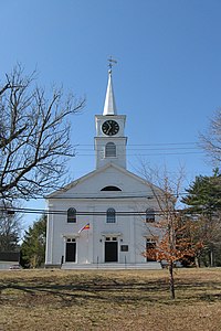
The Bryant–Cushing House is a historic First Period house at 768 Main Street in Norwell, Massachusetts. The oldest portion of this 2+1⁄2-story wood-frame house was built c. 1698 by Deacon Thomas Bryant. It is five bays wide and two deep, and has a large central chimney. The main entrance is centered on the front facade, and is flanked by fluted pilasters supporting a pediment. The house was in the locally prominent Cushing family for roughly two hundred years. Much of the land formerly associated with the house now forms part of the adjacent Norris Reservation, conservation land owned by The Trustees of Reservations.

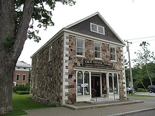
The Sutton Center Historic District is a historic district encompassing the center of the village of Sutton, Massachusetts. The district, which covers 435 acres (176 ha), is centered on the junction of Boston Road, Singletary Avenue, and Uxbridge Road. Boston Road is a major east–west route through the town, and the other two roads run north–south through the village center. The Colombian building was built in 1957. A typically rural village center, its civic and institutional buildings are clustered near the intersection on its south side, in the general area of the town common. The town common and cemetery were laid out in 1719, after settlement of the township began in 1716. There are a few surviving houses that date to the middle of the 18th century or earlier; exact dates for most are uncertain. There are only a few institutional buildings: the 1829 Congregational Church, the 1983 Town Hall, built on the site of the town's first purpose-built town hall (1885), and Rufus Putnam Hall, an 1824 school building and Masonic lodge that now houses the local history museum. Only one commercial structure the 1839 Brick Block, stands in the village. There is also a historic animal pound, a rectangular stone structure used to pen stray livestock, which dates to the early days of the town.

The Five Corners Historic District is a historic district encompassing the central district of the village of South Williamstown, Massachusetts. It is centered at the junction of Cold Spring, Green River, New Ashford. The junction has been a prominent center in the area since 1760. Prominent buildings in the district include the South Center School, the Store at Five Corners, and the Second Congregational Church. The district was listed on the National Register of Historic Places in 1993.
The Sheffield Center Historic District encompasses the historic village center of Sheffield, Massachusetts. The village extends linearly along United States Route 7, roughly between Maple Avenue and Berkshire School Road, and includes the town's major civic and religious buildings. The area's principal period of development was between 1760 and the 1890s. It was listed on the National Register of Historic Places in 1989.

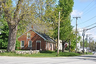
The Heath Center Historic District encompasses a rural village with predominantly 18th- and 19th-century structures in Heath, a small agricultural town in hills of northwestern Franklin County, Massachusetts, United States. The district is centered on the junction of several roads, around which the center of the town grew. South Road arrives from the south, East Main Street and Bray Road from the east, Ledge Road from the north, and West Main Street from the west.

The Hadley Center Historic District is an expansive, 2,500-acre (1,000 ha) historic district encompassing the village center of Hadley, Massachusetts. When it was first listed on the National Register of Historic Places in 1977, the district encompassed the town green and 17 buildings that faced it, at the junction of Russell Street and Middle Street. The district was expanded significantly in 1994, adding more than 400 buildings representative of the village's growth from colonial days into the first decades of the 20th century. This expansion encompasses the entirety of a tongue of land extending west from East Street and bounded by a bend in the Connecticut River, which separates Hadley from Northampton. Its oldest property, the Samuel Porter House on West Street, was built in 1713.

The Hatfield Center Historic District encompasses the traditional center of Hatfield, Massachusetts. The area, first laid out in 1661, is bounded by Maple Street to the south, the Connecticut River to the east, Day Avenue and School Street to the north, and the Mill River to the west. The area's layout and land use patterns are relatively little altered since they were laid out, leaving a well-preserved early colonial village landscape. The district was added to the National Register of Historic Places in 1994.

The Shirley Center Historic District encompasses the original historic center of Shirley, Massachusetts. The district is centered on the 1753 town common area, from which five roads radiate away. The district includes the buildings that surround the common, as well as some that line these roads. The district includes Shirley's town hall and First Parish Congregational Church.

Westford Center Historic District encompasses the historic village center of Westford, Massachusetts. It is centered on a stretch of Main Street between Graniteville and Leland Roads, extending away from this strip on a number of side streets. The area has been the town center since settlement of the town began in the 1720s. Prominent in the district are the Westford Academy building and the First Parish Church, two fine Federal style structures built in 1794, and the Italianate town hall, built in 1871.

The Common Historic District is a historic district encompassing the civic and institutional heart of Reading, Massachusetts. The district is centered on the town common, at the intersection of Main and Salem Streets. The common has been communally owned since at least 1737, with the original burying ground to the north. In 1769 the area's first meeting house was built, giving the area a sense of identity separate from portions of Reading that would later be set off as Wakefield and North Reading. Since then the area has become a focal point for religious and civic institutions in the town.

The Amherst Village Historic District encompasses the historic village center of Amherst, New Hampshire. Centered on the town's common, which was established about 1755, Amherst Village is one of the best examples of a late-18th to early-19th century New England village center. It is roughly bounded on the north by Foundry Street and on the south by Amherst Street, although it extends along some roads beyond both. The western boundary is roughly Davis Lane, the eastern is Mack Hill Road, Old Manchester Road, and Court House Road. The district includes the Congregational Church, built c. 1771-74, and is predominantly residential, with a large number of Georgian, Federal, and Greek Revival houses. Other notable non-residential buildings include the Farmer's Bank, a Federal-style brick building built in 1806, and the Amherst Brick School, a brick Greek Revival structure that has served as the School Administrative Unit 39 offices since 1997.

The Middlefield Center Historic District encompasses the historic village center of Middlefield, Massachusetts. It is centered on the junction of Skyline Trail, the main north-south road, with Bell and Town Hill Roads. The district was listed on the National Register of Historic Places in 2012.

The Lower Corner Historic District encompasses a small village center in the town of Sandwich, New Hampshire. Lower Corner is a rural village that is strung along New Hampshire Route 109 on either side of its junction with School House Road, about one mile from the main village of Center Sandwich. The village was developed relatively early in Sandwich's history, although its oldest buildings now date to the early 19th century. There are 25 contributing structures, mostly residences. There are two buildings built as stores, including one of brick; all the other buildings are wood frame. The district was listed on the National Register of Historic Places in 1986.
The New Ipswich Center Village Historic District encompasses the historic center of the rural town of New Ipswich, New Hampshire. The center village is the town's most densely populated area, with a history dating to the town's founding in 1735. The district extends along Turnpike Road between King and Porter Roads, and southward in a roughly triangular shape, the southern point of which is at the junction of Main Street and Willard Road. The village includes a large number of residences, which were mainly agricultural at first, but also include a number of properties built as summer resort houses in the late 19th and early 20th centuries. It also includes most of the town's historic civic buildings, including its historic town hall, and the Barrett House, now a museum property owned by Historic New England. The district was listed on the National Register of Historic Places in 1991.

The Strafford Village Historic District encompasses the historic village center of Strafford, Vermont, United States. Founded in 1768, the village center was developed in the 1790s, and saw most of its growth before 1840, resulting in a fine assortment of predominantly Greek Revival buildings. Notable exceptions include the 1799 meetinghouse, and the Justin Smith Morrill Homestead, a fine example of Gothic Revival architecture built by native son Justin Smith Morrill. The district, centered on the town green at the junction of Morrill Highway and Brook Road, was listed on the National Register of Historic Places in 1974.