
The Massachusetts Water Resources Authority (MWRA) is a public authority in the Commonwealth of Massachusetts that provides wholesale drinking water and sewage services to 3.1 million people in sixty-one municipalities and more than 5,500 large industrial users in the eastern and central parts of the state, primarily in the Boston area.

Boston Harbor is a natural harbor and estuary of Massachusetts Bay, located adjacent to Boston Massachusetts. It is home to the Port of Boston, a major shipping facility in the Northeastern United States.

Ragged Island is an island in the Hingham Bay area of the Boston Harbor Islands National Recreation Area, in the U.S. state of Massachusetts. The island has a permanent size of 4 acres (16,000 m2), and it is composed of Roxbury puddingstone which rises to a height of 30 feet (9.1 m) above sea level. Broken ledges surround most of the island with small gravel beaches on the southeast and northwest sides; there are also small tidal mudflats.

Spectacle Island is a 114-acre (46 ha) island in Boston Harbor, 4 miles (6.4 km) offshore of downtown Boston, Massachusetts. It is part of the city of Boston. The island has a varied history, and today is a public park with a marina, visitor center, cafe, lifeguarded swimming beach, and five miles of walking trails, forming part of the Boston Harbor Islands National Recreation Area. It is served all year by ferries from Boston, and on weekends and summer weekdays by a shuttle boat to and from nearby islands.
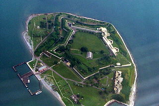
Georges Island is one of the islands in the Boston Harbor, situated just over 7 miles (11 km) from downtown Boston. The island has a permanent size of 39 acres (160,000 m2), plus an intertidal zone of a further 14 acres (57,000 m2), and rises to a height of 50 feet (15 m) above sea level. Historic Fort Warren is on the island. Because of this, and since a ferry operates from Boston to the island, it is a popular destination and one of the easiest islands to access in the Boston Harbor Islands National Recreation Area.
Conservation Law Foundation (CLF) is an environmental advocacy organization based in New England, United States. Since 1966, CLF's mission has been to advocate for New England's environment and its communities. CLF's advocacy work takes place across five integrated program areas: Clean Energy & Climate Change, Clean Air & Water, Healthy Oceans, People & Justice, and Healthy Communities. CLF's mission statement is to "use the law, science, and the market to create solutions that preserve natural resources, build healthy communities, and sustain a vibrant economy." CLF focuses on promoting renewable energy and fight air and water pollution; building sustainable fishing communities and protect marine habitat; promoting public transit and defend public health; achieving environmental justice; and sustaining a vibrant, equitable economy.

Houghs Neck is a one-square-mile (2.6 km2) peninsula in Quincy, Massachusetts. It is surrounded by Quincy Bay, Hingham Bay and Rock Island Cove. It is lined by Perry Beach, which runs along Manet Avenue; Nut Island, which is just beyond Great Hill at the very end of the peninsula; and Edgewater Drive.
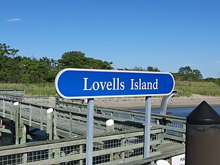
Lovells Island, or Lovell's Island, is a 62-acre (250,000 m2) island in the Boston Harbor Islands National Recreation Area, in Massachusetts. The island is across The Narrows from Georges Island and some 7 miles (11 km) offshore of downtown Boston. It is named after Captain William Lovell, who was an early settler of nearby Dorchester. The island is known as the site of several shipwrecks, including the 74-gun French warship Magnifique in 1782.

Moon Island is an island in Quincy Bay, in the middle of Boston Harbor, Massachusetts. It is the location of the Boston Fire Department Training Academy, and Boston Police Department shooting range. All of the land on the island is owned by the City of Boston but the island is under the jurisdiction of Quincy, Massachusetts. It is also part of the Boston Harbor Islands National Recreation Area.

Great Brewster Island is one of the outer islands in the Boston Harbor Islands National Recreation Area, situated some 9 miles (14 km) offshore of downtown Boston. The island has a permanent size of 18 acres (73,000 m2), plus an intertidal zone of a further 49 acres (200,000 m2). Unlike the other outer islands, which are low-lying outcroppings of bedrock, Great Brewster is a drumlin which reaches a height of over 100 feet above sea level. It has vegetation cover consisting of Apple Trees, Pear Trees, Sumac, Beach Roses, Grasses and Common Reeds, together with a large Gull colony. The birds are aggressive during nesting season and access by humans, which is by private boat only, is discouraged during that time.

Deer Island is a peninsula in Boston, Massachusetts. Since 1996, it has been part of the Boston Harbor Islands National and State Park. Although still an island by name, Deer Island has been connected to the mainland since the former Shirley Gut channel, which once separated the island from the town of Winthrop, was filled in by the 1938 New England hurricane. Today, Deer Island is the location of the Deer Island Wastewater Treatment Plant, whose 150-foot-tall (46 m) egg-like sludge digesters are major harbor landmarks.
The Boston Harbor Islands Partnership is a non-profit partnership organization based in Boston, whose purpose is "to coordinate the activities of the Federal, State, and local authorities and the private sector in the development and implementation of a general management plan" for the Boston Harbor Islands National Recreation Area. The Partnership was established by the United States Congress in 1996, as part of the law which designated the Boston Harbor Islands as a unit of the national parks system.

The Deer Island Waste Water Treatment Plant is located on Deer Island, one of the Boston Harbor Islands in Boston Harbor. The plant is operated by the Massachusetts Water Resources Authority (MWRA) and began partial operations in 1995. The facility was fully operational in 2000 with the completion of the outfall tunnel.

Mount Hope Bay is a tidal estuary located at the mouth of the Taunton River on the Massachusetts and Rhode Island border. It is an arm of Narragansett Bay. The bay is named after Mount Hope, a small hill located on its western shore in what is now Bristol, Rhode Island. It flows into the East Passage of Narragansett Bay and also the Sakonnet River. Mount Hope Bay has played an important role to the history of the area, from pre-colonial times to the present. While many years of sewage and industrial pollution have severely degraded the quality of the shallow waters of the bay, there are currently major efforts underway to clean up and restore it.

Armando David Mazzone served for twenty-six years as a United States district judge of the United States District Court for the District of Massachusetts.

The Misery Islands are an 87-acre (350,000 m2) nature reserve established in 1935 in Salem Sound close to the Salem Harbor in Salem, Massachusetts. It is managed by the Trustees of Reservations. The islands are a part of the city of Salem, although they are much closer to the mainland of the city of Beverly, in whose aquatic territory they lie.
The Nut Island effect describes an organizational behavior phenomenon in which a team of skilled employees becomes isolated from distracted top managers resulting in a catastrophic loss of the ability of the team to perform an important mission. The term was coined by Paul F. Levy, a former Massachusetts state official, in an article in the Harvard Business Review published in 2001. The article outlines a situation which resulted in massive pollution of Boston Harbor, and proposes that the name of the facility involved be applied to similar situations in other business enterprises. The work is used as a source in human resources management case studies and is featured on the websites of several business management consulting firms and health care institutions.

Fort Heath was a US seacoast military installation for defense of the Boston and Winthrop Harbors with an early 20th-century Coast Artillery fort, a 1930s USCG radio station, prewar naval research facilities, World War II batteries, and a Cold War radar station. The fort was part of the Harbor Defenses of Boston and was garrisoned by the United States Army Coast Artillery Corps. The fort's military structures have been replaced by a residential complex, including the luxurious Forth Heath Apartments, and recreation facilities of Small Park, which has both a commemorative wall and an historical marker for Fort Heath.
The South Boston CSO Storage Tunnel, also known as the North Dorchester Bay CSO Storage Tunnel, is a large underground facility designed to reduce untreated sewage discharges into Boston Harbor from the Massachusetts Water Resources Authority combined sewer and stormwater system. It was opened on July 23, 2011, and is part of the federally mandated Boston Harbor Cleanup project. CSO stands for Combined Sewer Overflow.
The Great Hunger Memorial is a 16-foot tall Celtic cross located on Deer Island in Boston Harbor.
