Related Research Articles

Green Island, also known as North Brewster Island, is a rocky outer island in the Boston Harbor Islands National Recreation Area, to the north of Calf Island and Hypocrite Channel. The island has a permanent size of 2.5 acres (10,000 m2), plus an intertidal zone of a further 15 acres (61,000 m2), and is exposed from the east and northeast with little soil or plant life. The island is named after Joseph Green, a well-known merchant, who owned the island during Colonial times.
Commissioners Ledge is a small barren rock in Massachusetts Bay, located within the city limits of Boston, Massachusetts, United States. The rock is west of Maffitt Ledge, northwest of Green Island, north of Half Tide Rocks, and northeast of Devils Back. Also, it borders the northeast boundary of the South Channel.
Alden island is a very small island within the Duck Hill marshland in Duxbury, Massachusetts. A small unpaved road connects the island with the mainland to Harmony Hill Road.
Allen Rock is a small marshy island in the marshlands of Salisbury, Massachusetts. The island is northwest of the Salisbury Beach State Reservation.

Averills Island is a small forested island within the marshland of the Wenham Swamp, in the Ipswich River Wildlife Sanctuary in Topsfield, Massachusetts. There is an unpaved road that connects the island with the mainland, from Bradstreet Hill to the Steward School on Perkins Row.

Bagwell Island is a small barren island within the Eagle Hill River, in Ipswich, Massachusetts, United States. The island is off the northwestern coast of Great Neck, just west of Eagle Hill Road on Eagle Hill.
Barrel Rock is a small barren rock within the edge of Cohasset Harbor in Cohasset, Massachusetts, USA. The rock is north of Sutton Rocks, northwest of Quarry Point, south of Chittenden Rock, and east of Brush Island. It is located at 42°15′32″N70°47′6″W

Urdoviza Glacier is a glacier on western Livingston Island in the South Shetland Islands, Antarctica situated east of the northern portion of Etar Snowfield and north of Medven Glacier. It extends 1.5 nautical miles in the east-west direction and 1.5 nautical miles in the north-south direction, and is bounded by the eastern slopes of Oryahovo Heights and draining eastwards into Stoyanov Cove of Hero Bay between Agüero Point and Sandanski Point. Bulgarian mapping in 2005 and 2009.
Middle Brewster Island is a rugged outer island in the Boston Harbor Islands National Recreation Area, located 9 miles (14 km) offshore from downtown Boston. The island has a permanent size of 13 acres (53,000 m2), reaches a height of 52 feet (16 m) above sea level, and is bounded by sharp cliffs and sunken crags. It has only sparse vegetation and serves primarily as a nesting site for gulls and cormorants. The birds are aggressive during their nesting season and access by humans is discouraged during this period. Access is difficult due to the lack of beaches and inlets, and is only accessible by private boat.

Tinkers Island is a pair of small islands off the coast of Marblehead, Massachusetts, United States. It is only accessible by boat and houses several small camps. The island was named after the breed of mackerel that can be found close to its shores.
The Roger Island River is a small tidal estuary between Ipswich and Rowley, Massachusetts. It is a southern branch of the larger Rowley River passing around Roger Island.
Holy Island is a marshy island located off the northeast coast of Massachusetts, north of Cape Ann. The island is situated immediately west of Plum Island and is part of the Town of Ipswich in Essex County. The Rowley River runs by the island, which is the northernmost of four marshy islands.
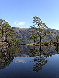
Eilean Ruairidh Mòr is a forested island in Loch Maree, Wester Ross, Scotland. Its name was formerly anglicised as "Ellan-Rorymore".

The Misery Islands are an 87-acre (350,000 m2) nature reserve established in 1935 in Salem Sound close to the Salem Harbor in Salem, Massachusetts. It is managed by the Trustees of Reservations. The islands are a part of the city of Salem, although they are much closer to the city of Beverly, in whose aquatic territory they lie.
Brighton is an unincorporated area in the town of Tonawanda in Erie County, New York, United States.
Egg Rock in Nahant Bay near Nahant, Massachusetts is a small (3-acre) island at 42.4333°N 70.8978°W. It was formerly the site of a lighthouse known as Egg Rock Light but now is owned by the state of Massachusetts as a bird sanctuary. Egg Rock can be seen clearly from the coasts of Nahant, Swampscott, and Lynn. Egg Rock is the setting for Sylvia Plath's poem "Suicide off Egg Rock", and also appears in her novel, The Bell Jar.
Chubb Island is a small barren island located in Manchester Bay in Beverly, Massachusetts.
Corn Island is a forested island of Essex County, Massachusetts.
Dole Island is an island located in the Parker River in Newbury, Massachusetts. The Parker River National Wildlife Refuge is located on it.
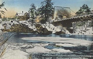
Deer Island is a small island with only 1-2 residences, located in the Merrimack River in Amesbury, Massachusetts. The island connects to mainland Amesbury by way of the Derek S. Hines Memorial Bridge, and to neighboring Newburyport via Chain Bridge.
References
- ↑ "Coney Island". Geographic Names Information System . United States Geological Survey . Retrieved March 17, 2014.
Coordinates: 42°31′45″N70°50′13″W / 42.52917°N 70.83694°W
| | This Essex County, Massachusetts geography–related article is a stub. You can help Wikipedia by expanding it. |