Pemberton Point

Last updated
Pemberton Point

Windmill Point
Windmill Point Hull Massachusetts 2507179597 57a62bddfb o.jpg
Aerial view of Pemberton Point, 2008
USA Massachusetts location map.svg
Red pog.svg
Pemberton Point
Location of Pemberton Point within Massachusetts
Coordinates: 42°18′17″N70°55′10″W / 42.30472°N 70.91944°W / 42.30472; -70.91944 Coordinates: 42°18′17″N70°55′10″W / 42.30472°N 70.91944°W / 42.30472; -70.91944
Country United States
State Massachusetts
County Plymouth
Town Hull
Time zone UTC-5 (Eastern)
  Summer (DST) UTC-4 (Eastern)
ZIP code
02045
Area code(s) 339 / 781

Pemberton Point (formerly known as Windmill Point) is a peninsula in Hull, Massachusetts. It is located at the tip of the Nantasket Peninsula, in Boston Harbor.

Contents

History

Historic manuscripts have called the location "Windmill Point" since the 1820s. [1] The windmills for which the point were named were used by two brothers to pump seawater into vats to be used for harvesting salt. [1] [2] [3] The salt would then be used to pack fish. [2]

On July 13, 1909, fourteen-year-old Rosie Pitenhof swam across the Hull Gut from Peddocks Island to Pemberton Point and back, believed to be the first to do so. [4]

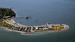
Hull High School, the town's public high school, opened on the point in 1957. [5]

Wind turbines

"Hull Wind 1" Hull 1 wind turbine 2775994684 683df13fd6 o.jpg
"Hull Wind 1"

An Enertech 40 kW wind turbine was installed on Pemberton Point and started energy production in March 1985. [6] [7] The turbine was funded by the Massachusetts Department of Energy Resources, and was sited adjacent to the high school. [7] It was damaged beyond repair by a storm in March 1997, [1] [7] and was removed after a new wind turbine, nicknamed "Hull Wind 1", was installed nearby at the end of 2001. [6]

Hull Wind 1

Hull Wind 1, a new Vestas V47 turbine capable of producing 660 kW, began producing power on Pemberton Point in December 2001. It stands 150 feet (46 m) tall. [8] It is the first commercial wind turbine on the East Coast of the United States [6] and in the whole of New England. [1] It is also the first commercial urban turbine in North America. [6] During its first year of operation, it saved Hull over $100,000. [2] In 2003, planning began for an additional wind turbine known as "Hull Wind 2". [7] It was initially suggested that it be located near Hull Wind 1, but after concerns were expressed by nearby residents over having two in close proximity, the new Vestas V80 1.8 MW wind turbine was installed on a landfill to the east, away from Pemberton Point, and began operation in May 2006. [1]

Facilities

The United States Coast Guard Station Point Allerton was built in 1969 and is located near the point. [9] It was commissioned on April 18, 1970. [10] Point Allerton Lifesaving Station, which opened on October 15, 1889, [10] used to hold the United States Coast Guard before the present station was built.

The Massachusetts Bay Transportation Authority runs boats from Pemberton Point to both Long Wharf and Logan Airport. [11]

Pemberton Point Pier is a popular fishing location. [12]

See also

Related Research Articles

Hull, Massachusetts Town in Massachusetts, United States

Hull is a town in Plymouth County, Massachusetts, United States, located on a peninsula at the southern edge of Boston Harbor. Its population was 10,293 at the 2010 census. Hull is the smallest town by land area in Plymouth County and the fourth smallest in the state. However, its population density is within the top thirty towns in the state.

Vestas Danish wind turbine company

Vestas Wind Systems A/S is a Danish manufacturer, seller, installer, and servicer of wind turbines that was founded in 1945. The company operates manufacturing plants in Denmark, Germany, The Netherlands, Taiwan, India, Italy, Romania, The United Kingdom, Spain, Sweden, Norway, Australia, China, Brazil, Poland and the United States, and employs more than 25,000 people globally.

History of wind power Aspect of history

Wind power has been used as long as humans have put sails into the wind. For more than two millennia wind-powered machines have ground grain and pumped water. Wind power was widely available and not confined to the banks of fast-flowing streams, or later, requiring sources of fuel. Wind-powered pumps drained the polders of the Netherlands, and in arid regions such as the American mid-west or the Australian outback, wind pumps provided water for livestock and steam engines.

Siemens Gamesa

Siemens Gamesa Renewable Energy S.A., formerly Gamesa Corporación Tecnológica S.A. and Grupo Auxiliar Metalúrgico S.A., is a Spanish-German wind engineering company based in Zamudio, Biscay, Spain. It manufactures wind turbines and provides onshore and offshore wind services. It is the world's second largest wind turbine manufacturer.

Wind power in India Overview of wind power in India

Wind power generation capacity in India has significantly increased in recent years. As of 30 September 2020, the total installed wind power capacity was 38.124 GW, the fourth largest installed wind power capacity in the world. Wind power capacity is mainly spread across the Southern, Western and Northern regions.

Wind power in Scotland Overview of wind power in Scotland

Wind power in Scotland is the fastest-growing renewable energy technology, with 9,347 MW of installed wind power capacity as of June 2020. This included 8,366 MW from onshore wind in Scotland and 981 MW of offshore wind generators.

Wind power in Ohio Electricity from wind in one U.S. state

Wind power in Ohio has a long history, and as of 2016, Ohio had 545 megawatts (MW) of utility-scale wind power installations installed, responsible for 1.1% of in-state electricity generated. Over 1000 MW more were under construction or pending approval. Some installations have become tourist attractions. There has been a sudden increase in generating capacity, as total wind power capacity in the state was just 9.7 MW in 2010. By 2019, there were 738 MW of capacity, which generated 1.71% of Ohio's electricity.

Joshua James (lifesaver)

Joshua James was an American sea captain and a U.S. Life–Saving Station keeper. He was a famous and celebrated commander of civilian life-saving crews in the 19th century, credited with saving over 500 lives from the age of about 15 when he first associated himself with the Massachusetts Humane Society until his death at the age of 75 while on duty with the United States Life–Saving Service. During his lifetime he was honored with the highest medals of the Humane Society and the United States. His father, mother, brothers, wife, and son were also lifesavers in their own right.

Floating wind turbine

A floating wind turbine is an offshore wind turbine mounted on a floating structure that allows the turbine to generate electricity in water depths where fixed-foundation turbines are not feasible. Floating wind farms have the potential to significantly increase the sea area available for offshore wind farms, especially in countries with limited shallow waters, such as Japan. Locating wind farms further offshore can also reduce visual pollution, provide better accommodation for fishing and shipping lanes, and reach stronger and more consistent winds.

Community wind energy

Community wind projects are locally owned by farmers, investors, businesses, schools, utilities, or other public or private entities who utilize wind energy to support and reduce energy costs to the local community. The key feature is that local community members have a significant, direct financial stake in the project beyond land lease payments and tax revenue. Projects may be used for on-site power or to generate wholesale power for sale, usually on a commercial-scale greater than 100 kW.

Point Allerton Lifesaving Station United States historic place

Point Allerton Lifesaving Station is a historic building of the United States Life-Saving Service at 1117 Nantasket Avenue in Hull, Massachusetts. The service was eventually merged with the Revenue Cutter Service to form the United States Coast Guard. The Queen Anne style station was built in 1889 by the United States Army Corps of Engineers. It is a minimally-decorated building, scaled to fit into the surrounding residential area. Its first commander was Hull native Joshua James, whose heroic career in lifesaving is detailed in the museum. Keeper William Sparrow commanded the station through its transition to the United States Coast Guard in 1915.

Wind power in Maine Electricity from wind in one U.S. state

There are a number of wind power projects in the state of Maine, totaling more than 900 megawatts (MW) in capacity and responsible for 13.85% of in-state electricity production in 2017. In 2019, Maine had more wind capacity than the other five New England states combined, at 923 MW.

Wind turbine

A wind turbine, or alternatively referred to as a wind energy converter, is a device that converts the wind's kinetic energy into electrical energy.

Coast Guard Station Point Allerton

United States Coast Guard Station Point Allerton is a United States Coast Guard station located in Hull, Massachusetts.

Hull Gut

Hull Gut is a gut about half a mile wide and thirty-five feet deep, in Boston Harbor running between Pemberton Point in Hull and the East Head of Peddocks Island. Along with its sister channel, West Gut, which runs between the West Head of Peddocks Island and Hough's Neck in Quincy, Hull Gut forms the southern entrance to the Inner Harbor connecting it to Hingham Bay. To the north the gut intersects with the deep-water shipping lane Nantasket Roads. Strong cross-currents and often heavy traffic make the gut a dangerous waterway. The channel is used by oil tankers and other freighters bound for industries around the Weymouth Fore River in Braintree, Weymouth, and Quincy and, historically, was used by the shipbuilding industry.

Hingham Bay

Hingham Bay is the easternmost of the three small bays of outer Boston Harbor, part of Massachusetts Bay and forming the western shoreline of the town of Hull and the northern shoreline of Hingham in the United States state of Massachusetts. It lies east of Quincy Bay and is met at the southwest by the mouth of Weymouth Fore River, also forming part of the waterfront of Weymouth. The bay is home to several of the Boston Harbor Islands.

Wind turbines on public display

The great majority of wind turbines around the world belong to individuals or corporations who use them to generate electric power or to perform mechanical work. As such, wind turbines are primarily designed to be working devices. However, the large size and height above surroundings of modern industrial wind turbines, combined with their moving rotors, often makes them among the most conspicuous objects in their areas. A few localities have exploited the attention-getting nature of wind turbines by placing them on public display, either with visitor centers on their bases, or with viewing areas farther away. The wind turbines themselves are generally of conventional horizontal-axis, three-bladed design, and generate power to feed electrical grids, but they also serve the unconventional roles of technology demonstration, public relations, and education.

Wind power in New Jersey Electricity from wind in one U.S. state

Wind power in New Jersey is in the early stages of development. There are various projects underway to create windfarms along coastal areas in the state on land, on piers, and on the continental shelf of the Atlantic Ocean off the southern Jersey Shore. Legislation has been enacted to support the industry through economic incentives and to permit wind turbines on existing piers. Several proposals have been made to expand the use of wind-generated power and offshore wind power.

Wind power in Rhode Island Electricity from wind in one U.S. state

Wind power in Rhode Island is in the early stages of development. There are several small scale wind turbine projects in the state. As of December 2013 there were 11 turbines at 10 sites in the state. In 2014, Rhode Island had 9 MW of installed wind power capacity, which quickly rose to 75 MW in 2019.

Wind power in Virginia Electricity from wind in one U.S. state

Wind power in Virginia is in the early stages of development. In March 2015, Virginia became the first state in the United States to receive a wind energy research lease to build and operate offshore wind turbines in federal waters. As of 2019, Virginia had no utility scale wind farms.

References

  1. 1 2 3 4 5 Manwell, James F.; MacLeod, John; Wright, Sally; DiTullio, Lynn; McGowan, Jon G (June 2006). "Hull Wind II: A Case Study of the Development of a Second Large Wind Turbine Installation in the Town of Hull, MA" (PDF). American Wind Energy Association. Archived from the original (PDF) on November 2, 2013. Retrieved June 5, 2012.
  2. 1 2 3 Cherry, Jonathan S. (June 2008). "The windy city: Harnessing Power in the Neighborhood Landscape" (PDF). Massachusetts Institute of Technology. pp. 19, 22. Archived from the original (PDF) on November 2, 2013. Retrieved July 22, 2012.
  3. Sweeney, Emily (January 23, 2011). "Hull harvests rewards of wind power". The Boston Globe . Retrieved July 11, 2012.
  4. "Girl Swims Hull Gut: 14-Year-old Miss First Person to Accomplish Hard Task at Boston" (PDF). The New York Times . July 14, 1909. Retrieved July 8, 2012.
  5. "Hull High School: 2011 - 2012 School Profile" (PDF). Hull High School . p. 1. Archived from the original (PDF) on March 28, 2012. Retrieved July 11, 2012.
  6. 1 2 3 4 Manwell, J. F.; McGowan, J. G.; Rogers, A.; Ellis, A.; Wright, S. (2003). "Wind Turbine Siting in an Urban Environment: The Hull, MA 660 KW Turbine" (PDF). American Wind Energy Association. p. 10. Archived from the original (PDF) on October 21, 2013. Retrieved July 22, 2012.
  7. 1 2 3 4 "History of Hull's wind project". HullWind.org. 2006. Retrieved July 10, 2012.
  8. "Hull Wind: 6,000,000 kWhs of clean energy" (PDF). HullWind.org. December 1, 2005. Retrieved July 10, 2012.
  9. "Massachusetts, Hull, Plymouth Co". Sail 1620. 2012. Archived from the original on June 9, 2012. Retrieved June 7, 2012.
  10. 1 2 "History - Station Point Allerton". United States Coast Guard . January 26, 2012. Retrieved July 12, 2012.
  11. "Boat Map and Schedules". MBTA . Retrieved August 8, 2013.
  12. Broach, Heidi. "Massachusetts Onshore Fishing Hot Spots". USA Today . Retrieved July 25, 2012.