Hangman Island, also known as Hayman's Island, is an island in the Quincy Bay area of the Boston Harbor Islands National Recreation Area. The island is a barren outcrop of bedrock, with a permanent size of half an acre rising to only three feet above sea level, plus an intertidal zone of a further 5 acres (20,000 m2). Access is by private boat only.
Green Island, also known as North Brewster Island, is a rocky outer island in the Boston Harbor Islands National Recreation Area, to the north of Calf Island and Hypocrite Channel. The island has a permanent size of 2.5 acres (10,000 m2), plus an intertidal zone of a further 15 acres (61,000 m2), and is exposed from the east and northeast with little soil or plant life. The island is named after Joseph Green, a well-known merchant, who owned the island during Colonial times.
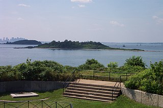
Ragged Island is an island in the Hingham Bay area of the Boston Harbor Islands National Recreation Area, in the U.S. state of Massachusetts. The island has a permanent size of 4 acres (16,000 m2), and it is composed of Roxbury puddingstone which rises to a height of 30 feet (9.1 m) above sea level. Broken ledges surround most of the island with small gravel beaches on the southeast and northwest sides; there are also small tidal mudflats.
Shag Rocks are barren rocks situated 8 nautical miles offshore of Custom House Tower in downtown Boston, in the Boston Harbor Islands National Recreation Area and within the city limits of Boston. The rocks are northeast of Little Brewster Island and east of Great Brewster Island and have been the site of several shipwrecks. Boston Light on Little Brewster Island warns mariners to steer clear of the rocks. Public access is impractical.
Badgers Rock is a small barren rock within the Merrimack River, in Salisbury, Massachusetts, United States. The rock is just south of the light campground area of the Salisbury Beach State Reservation and north of Plum Island Point on Plum Island in Newburyport.
The Barbados raccoon is an extinct subspecies of the common raccoon, that was endemic on Barbados in the Lesser Antilles until 1964.

Houghs Neck is a one-square-mile (2.6 km2) peninsula in Quincy, Massachusetts. It is surrounded by Quincy Bay, Hingham Bay and Rock Island Cove. It is lined by Perry Beach, which runs along Manet Avenue; Nut Island, which is just beyond Great Hill at the very end of the peninsula; and Edgewater Drive.

Uncatena Island is one of the Elizabeth Islands of Dukes County, Massachusetts, United States. It is the most northerly of the Elizabeth Islands and lies just off the northernmost point of Naushon Island. Uncatena has a land area of 0.492 km², and was uninhabited as of the 2000 census. It is part of the Town of Gosnold.

Little Brewster Island is a rocky outer island in the Boston Harbor Islands National Recreation Area. It is best known as the location of Boston Light, one of only five remaining Coast Guard-manned lighthouses in the United States, and an important navigation aid for traffic to and from the Port of Boston. The island is situated some 9 miles (14 km) offshore of downtown Boston and has a permanent size of 3 acres (12,000 m2), plus an intertidal zone of a further 4 acres (16,000 m2).

Bumpkin Island, also known as Round Island, Bomkin Island, Bumkin Island, or Ward's Island, is an island in the Hingham Bay area of the Boston Harbor. In 1902, Albert Burrage, a Boston philanthropist, had a summer hospital opened on the island for children with physical disabilities. During World War I the island was used by the U.S. Navy. Starting around 1940, the island was used as a facility for polio patients. However, the hospital closed during World War II and burned down in 1945. Since 1996, it is part of the Boston Harbor Islands National Recreation Area. The island has an area of 30 acres (120,000 m2), plus an intertidal zone of a further 31 acres (130,000 m2). It is composed of a central drumlin with an elevation of 70 feet (21 m) above sea level, surrounded by a rock-strewn shoreline. A sand spit, exposed at low tide, connects the eastern end of the island to Sunset Point in Hull.
Calf Island, also known as Apthorps Island, is a windswept island situated some 9 miles (14 km) offshore of downtown Boston in the Boston Harbor Islands National Recreation Area. The island has a permanent size of 18 acres (73,000 m2), plus an intertidal zone of a further 16 acres (65,000 m2), and has a thin layer of soil that supports vegetation including wild cherry, beach plum, grasses, chives, and mock orange. Access is by private boat only.
Middle Brewster Island is a rugged outer island in the Boston Harbor Islands National Recreation Area, located 9 miles (14 km) offshore from downtown Boston. The island has a permanent size of 13 acres (53,000 m2), reaches a height of 52 feet (16 m) above sea level, and is bounded by sharp cliffs and sunken crags. It has only sparse vegetation and serves primarily as a nesting site for gulls and cormorants. The birds are aggressive during their nesting season and access by humans is discouraged during this period. Access is difficult due to the lack of beaches and inlets, and is only accessible by private boat.
Gallops Island, also known as Gallups Island, is an island in the Boston Harbor Islands National Recreation Area, situated between Georges Island and Long Island and just over 6 miles (9.7 km) from downtown Boston. The island has a permanent size of 23 acres (93,000 m2), plus an intertidal zone of a further 28 acres (110,000 m2), and is composed of one large drumlin, reaching an elevation of 79 feet (24 m) above sea level. The island has a rocky beach and offers long vistas from the top of its grassy bluffs. Gallops Island is closed until asbestos remediation is completed.

Langlee Island or Langley Island is an island in the Hingham Bay area of the Boston Harbor Islands National Recreation Area. The island has a permanent size of 4 acres (16,000 m2), plus an intertidal zone of a further 3 acres (12,000 m2), and is composed of a massing of Roxbury puddingstone which rises to a height of 40 feet (12 m) above sea level. This results in steep cliffs on the northern shore, while there are several small sandy beaches and a tidal mudflat on the east side. The center of the island contains glacial till that supports tree and shrub cover. As a result of previous planting, the island hosts large examples of oak, maple, juniper, and birch trees, while self-seeded huckleberry and viburnum mix with common greenbriar, dewberry, sumac, and poison ivy.

Button Island is a small island in the Hingham Bay area of the Boston Harbor Islands National Recreation Area. It is part of the Town of Hingham. The island has a permanent size of under 1-acre (4,000 m2), plus an intertidal zone of a further 116 acres (0.47 km2). It is composed of a massing of glacial till which rises to a height of 10 feet (3.0 m) above sea level. The island is managed by the town of Hingham, and access is by private boat only.
Sarah Island is an island in the Hingham Bay area of the Boston Harbor Islands National Recreation Area. The island has a permanent size of just under 5 acres (20,000 m2), and is composed large outcroppings and ledges of Roxbury puddingstone together with glacial till which rises to a height of 30 feet (9.1 m) above sea level. The ledges, beaches and mudflats make the ideal nesting place for gulls.

Snake Island, also known as Bare Island, one of many Snake Island around world, is an island in Boston Harbor. The island is part of the Boston Harbor Islands National Recreation Area and is situated in the inner harbor between the town of Winthrop and the reclaimed land that forms Logan International Airport. It is part of the Town of Winthrop. It is named for its serpentine shape, and has a permanent size of 3 acres (12,000 m2), and rises to a height of 10 feet (3.0 m) above sea level.

Spinnaker Island is an island in the Hingham Bay area of Boston Harbor in Massachusetts, USA. The island is part of the town of Hull, to which it is connected by a bridge, and is one of the few harbor islands that neither forms part of the Boston Harbor Islands National Recreation Area nor is considered within the municipal limits of the city of Boston.

The raccoon, sometimes spelled racoon, also known as the common raccoon, North American raccoon,, northern raccoon, or coon, is a medium-sized mammal native to North America. The raccoon is the largest of the procyonid family, having a body length of 40 to 70 cm and a body weight of 5 to 26 kg. Its grayish coat mostly consists of dense underfur which insulates it against cold weather. Three of the raccoon's most distinctive features are its extremely dexterous front paws, its facial mask, and its ringed tail, which are themes in the mythologies of the indigenous peoples of the Americas. Raccoons are noted for their intelligence, with studies showing that they are able to remember the solution to tasks for at least three years. They are usually nocturnal and omnivorous, eating about 40% invertebrates, 33% plants, and 27% vertebrates.

The Misery Islands are an 87-acre (350,000 m2) nature reserve established in 1935 in Salem Sound close to the Salem Harbor in Salem, Massachusetts. It is managed by the Trustees of Reservations. The islands are a part of the city of Salem, although they are much closer to the city of Beverly, in whose aquatic territory they lie.


