
Hull is a town in Plymouth County, Massachusetts, United States, located on a peninsula at the southern edge of Boston Harbor. Its population was 10,072 at the 2020 census. Hull is the smallest town by land area in Plymouth County and the fourth smallest in the state. However, its population density is nearly four times that of Massachusetts as a whole.

The Abitibi River is a river in northeastern Ontario, Canada, which flows northwest from Lake Abitibi to join the Moose River which empties into James Bay. This river is 540 kilometres (340 mi) long, and descends 265 metres (869 ft). It is the fourth longest river in Ontario

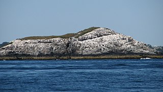
Green Island, also known as North Brewster Island, is a rocky outer island in the Boston Harbor Islands National Recreation Area, to the north of Calf Island and Hypocrite Channel. The island has a permanent size of 2.5 acres (10,000 m2), plus an intertidal zone of a further 15 acres (61,000 m2), and is exposed from the east and northeast with little soil or plant life. The island is named after Joseph Green, a well-known merchant, who owned the island during Colonial times.
Aldridge Ledge is a small barren rock located in the South Channel, within the city limits of Boston, Massachusetts. The rock is southwest of Devils Back and Half Tide Rocks, west of Little Calf Island and Hypocrite Channel, and northwest of Calf Island.
The Graves is an aggregation of rock outcroppings in Massachusetts Bay, Massachusetts, United States. Situated some 11 miles (18 km) offshore of downtown Boston, it is the outermost island in the Boston Harbor Islands National Recreation Area.
Martin Ledge is series of small barren rocks that barely stick out of the waters of Massachusetts Bay, within the city limits of Boston, Massachusetts, USA. The rocks are east of Tewksbury Rock and Outer Brewster Island and southwest of Three and One-half Fathom Ledge.
Tewksbury Rock is a small, subsurface rock pinnacle located in Massachusetts Bay, within the city limits of Boston. The rock is northeast of Outer Brewster Island, west of Martin Ledge, south east of Green Island and far north of Boston Ledge. It is 15 feet (4.6 m) to 18 feet (5.5 m) below the surface of the water, but more than 45 feet (14 m) above the hard gravel floor of the bay.
Long Island is an island in Lake Superior in Wisconsin usually identified with the Apostle Islands. It is geologically different from the other islands, though, in that it is actually just an extension of the spit off Chequamegon Point. It is a part of the Apostle Islands National Lakeshore, and is located in the Town of Sanborn, in Ashland County, Wisconsin.

Little Brewster Island is a rocky outer island in the Boston Harbor Islands National Recreation Area. It is best known as the location of Boston Light, one of only five remaining Coast Guard-staffed lighthouses in the United States, and an important navigation aid for traffic to and from the Port of Boston. The island is situated some 9 miles (14 km) offshore of downtown Boston and has a permanent size of 3 acres (12,000 m2), plus an intertidal zone of a further 4 acres (16,000 m2).

Great Brewster Island is one of the outer islands in the Boston Harbor Islands National Recreation Area, situated some 9 miles (14 km) offshore of downtown Boston. The island has a permanent size of 18 acres (73,000 m2), plus an intertidal zone of a further 49 acres (200,000 m2). Unlike the other outer islands, which are low-lying outcroppings of bedrock, Great Brewster is a drumlin which reaches a height of over 100 feet above sea level. It has vegetation cover consisting of Apple Trees, Pear Trees, Sumac, Beach Roses, Grasses and Common Reeds, together with a large Gull colony. The birds are aggressive during nesting season and access by humans, which is by private boat only, is discouraged during that time.

Outer Brewster Island, also known as Outward Island, is one of the outer islands in the Boston Harbor Islands National Recreation Area and is situated some 10 miles offshore of downtown Boston. The island has a permanent size of 20 acres, and consists of exposed bedrock covered by fertile soil bounded by a rocky shore with steep cliffs. It provides a nesting habitat for coastal water birds, including cormorants, gulls, common eider ducks, glossy ibis and American oystercatchers. The birds are aggressive during their nesting season and access by humans, which is by private boat only, is discouraged during this period.
Middle Brewster Island is a rugged outer island in the Boston Harbor Islands National Recreation Area, located 9 miles (14 km) offshore from downtown Boston. The island has a permanent size of 13 acres (53,000 m2), reaches a height of 52 feet (16 m) above sea level, and is bounded by sharp cliffs and sunken crags. It has only sparse vegetation and serves primarily as a nesting site for gulls and cormorants. The birds are aggressive during their nesting season and access by humans is discouraged during this period. Access is difficult due to the lack of beaches and inlets, and is only accessible by private boat.

The Pilgrim Hall Museum at 75 Court Street in Plymouth, Massachusetts is the oldest public museum in the United States in continuous operation, having opened in 1824.

Whitney and Thayer Woods is a nature reserve and forest located in Cohasset and Hingham, Massachusetts. The property is owned by The Trustees of Reservations. It is adjacent to the Weir River Farm, also owned by The Trustees, and Turkey Hill, a town-owned property managed by The Trustees.

Weir River Farm is a nature reserve located in Hingham, Massachusetts. The property is owned by The Trustees of Reservations. It is located adjacent to the Trustees-owned Whitney and Thayer Woods reservation, and the town-owned Turkey Hill property, which the Trustees manage.
Minot's Ledge, also known as the Cohasset Rocks, is a reef off the harbor of Cohasset, Massachusetts, 15 miles southeast of Boston, Massachusetts. It is the site of the Minot's Ledge Light, completed in 1860 and considered one of the most significant American engineering achievements of the 19th century. It was constructed by installing pins through tons of granite blocks into the rocks beneath to form the 40-foot base of the tower. The lighthouse is still operating. It is located within the Town of Scituate, in Plymouth County.

The Misery Islands are an 87-acre (350,000 m2) nature reserve established in 1935 in Salem Sound close to the Salem Harbor in Salem, Massachusetts. It is managed by the Trustees of Reservations. The islands are a part of the city of Salem, although they are much closer to the city of Beverly, in whose aquatic territory they lie.
Egg Rock in Nahant Bay near Nahant, Massachusetts is a small (3-acre) island at 42.4333°N 70.8978°W. It was formerly the site of a lighthouse known as Egg Rock Light but now is owned by the state of Massachusetts as a bird sanctuary. Egg Rock can be seen clearly from the coasts of Nahant, Swampscott, and Lynn. Egg Rock is the setting for Sylvia Plath's poem "Suicide off Egg Rock", and also appears in her novel, The Bell Jar.
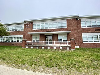
Cohasset High School is a public high school located in Cohasset, Massachusetts, United States. It is located at 143 Pond St. and has an enrollment of 364 students in grades 9-12. A majority of the school's team's are named the "Skippers" and the school colors are navy blue, silver, and white. Cohasset Middle School is attached to Cohasset High School which is under its own administration and serves grades 6-8.
Big Quamino Rock is a barren, uninhabited island located in Cohasset Harbor in Cohasset, Massachusetts.