Signy Island is a small subantarctic island in the South Orkney Islands of Antarctica. It was named by the Norwegian whaler Petter Sørlle (1884–1933) after his wife, Signy Therese.

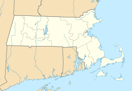
The Elizabeth Islands are a chain of small islands extending southwest from the southern coast of Cape Cod, Massachusetts in the United States. They are located at the outer edge of Buzzards Bay, north of Martha's Vineyard, from which they are separated by Vineyard Sound, and constitute the town of Gosnold in Dukes County, Massachusetts.

Thurston Island is an ice-covered, glacially dissected island, 215 km (134 mi) long, 90 km (56 mi) wide and 15,700 km2 (6,062 sq mi) in area, lying a short way off the northwest end of Ellsworth Land, Antarctica. It is the third largest island of Antarctica, after Alexander Island and Berkner Island.

Booth Island is a rugged, Y-shaped island, 8 kilometres (5 mi) long and rising to 980 m (3,215 ft) off the northwest coast of Kyiv Peninsula in Graham Land, Antarctica in the northeastern part of the Wilhelm Archipelago. The narrow passage between the island and the mainland is the Lemaire Channel.

Coronation Island is the largest of the South Orkney Islands, 25 nautical miles (46 km) long and from 3 to 8 nautical miles wide. The island extends in a general east–west direction, is mainly ice-covered and comprises numerous bays, glaciers and peaks, the highest rising to 1,265 metres (4,150 ft).
Lützow-Holm Bay is a large bay, about 220 kilometres (120 nmi) wide, indenting the coast of Queen Maud Land in Antarctica between Riiser-Larsen Peninsula and the coastal angle immediately east of the Flatvaer Islands. It was discovered by Captain Hjalmar Riiser-Larsen in two airplane flights from his expedition vessel, the Norvegia, on February 21 and 23, 1931. The name honours Commander Finn Lützow-Holm of the Royal Norwegian Navy Air Service, a pilot for Captain Riiser-Larsen on the Aagaard in 1935.

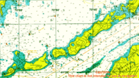
Nashawena Island is the second largest of the Elizabeth Islands of Dukes County, Massachusetts, United States. It lies between Cuttyhunk Island to the west and Pasque Island to the east. The island has a land area of 7.076 square kilometres and an official permanent population of 2 persons as of the 2000 U.S. Census. The island is part of the town of Gosnold, Massachusetts. Nashawena is an Indian word meaning "middle island". Rock Island and Baret Island are two small islands located north of Nashawena.
Canapitsit Channel is a channel that runs from Cuttyhunk Harbor to the Vineyard Sound and separates Nashawena Island from Cuttyhunk Island, two of the Elizabeth Islands off Cape Cod, Massachusetts. It is one of four straits allowing maritime passage between Buzzards Bay and the Vineyard Sound. The others are Quick's Hole, Robinson's Hole and Woods Hole. Canapitsit is an Indian word meaning "current passage".

The Willis Islands are a small archipelago to the west of South Georgia Island in the South Georgia Islands. They are 2 miles (3.2 km) west of Bird Island, separated by the Stewart Strait. They were discovered on 14 January 1775 by Captain James Cook and named for Cook's midshipman Thomas Willis, the crew member who first sighted them. The Willis Islands were charted in greater detail and individually named by Discovery Investigations (DI) personnel between 1926-1930.

Annenkov Island is to the west of the main island of South Georgia. The Pickersgill Islands are to its southeast. It is irregularly shaped and 4 miles (6.4 km) long and 650 m (2,130 ft) high, lying 8 miles (13 km) off the south-central coast of South Georgia.
Barff Peninsula is a peninsula forming the east margin of Cumberland East Bay, South Georgia Island. It is 8 miles (13 km) long and extends northwest from Sörling Valley to Barff Point, its farthest extremity. It was probably first seen by the British expedition under James Cook in 1775. The peninsula as a whole takes its name from Barff Point, which was named for Royal Navy Lieutenant A.D. Barff of HMS Sappho, who, assisted by Captain C.A. Larsen, sketched a map of Cumberland Bay in 1906. Barff Point is considered the eastern headland of East Cumberland Bay.

The Bay of Isles is a bay 9 miles (14 km) wide and receding 3 miles (5 km), lying between Cape Buller and Cape Wilson along the north coast of South Georgia. It was discovered in 1775 by a British expedition under James Cook and so named by him because numerous islands lie in the bay. Of South Georgia's 31 breeding bird species, 17 are found here.
Quick's Hole is the strait in Massachusetts' Elizabeth Islands separating Nashawena Island from Pasque Island. It is one of four straits allowing maritime passage between Buzzards Bay and the Vineyard Sound. The others are Canapitsit Channel, Robinson's Hole and Woods Hole.
The Flatvaer Islands, also known as the Ongul Islands, are a group of small islands lying at the east side of the entrance of Lützow-Holm Bay, 4 km from the coastline of Antarctica. They were mapped by Norwegian cartographers from air photos taken by the Lars Christensen Expedition (LCE), 1936–37. Many of the islands and their features were subsequently named by members of the Japanese Antarctic Research Expedition (JARE); unless otherwise noted, features noted in this article were named by JARE.
Cuttyhunk Harbor is a bay in Dukes County, Massachusetts. It is located between Copicut Neck on Cuttyhunk Island and Nashawena Island 0.5 miles (0.80 km) northeast of Cuttyhunk in the Town of Gosnold. Cuttyhunk Harbor is connected to Vineyard Sound by Canapitsit Channel. Cuttyhunk is an Indian word meaning "cleared land" or "plantation".
Rock Island is one of the Elizabeth Islands in Dukes County, Massachusetts, United States. It is located in Buzzards Bay off the north shore of Nashawena Island, 2.3 miles (3.7 km) east-northeast of Cuttyhunk in the Town of Gosnold.
Saddleback Hill is a mountain in Dukes County, Massachusetts. It is located on Nashawena Island 2.2 miles (3.5 km) east-northeast of Cuttyhunk in the Town of Gosnold. Middle Pond is located east of Saddleback Hill.