Related Research Articles

Prairie Grove is a village in McHenry County, Illinois, United States, first incorporated in 1973. The population was 1,904 at the 2010 census. Prairie Grove's schools and main social and economic life are shared with the city of Crystal Lake.

Gilliam is a village in Caddo Parish, Louisiana, United States. The population was 164 at the 2010 census. It is part of the Shreveport–Bossier City Metropolitan Statistical Area.

Conklin is a town in Broome County, New York, United States. The population was 5,441 at the 2010 census.
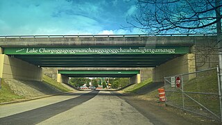
Lake Chaubunagungamaug, also known as Webster Lake, is a lake in the town of Webster, Massachusetts. It is located near the Connecticut border and has a surface area of 1,442 acres. Since 1921, the lake has also been known by a much longer name having 45 letters comprising fourteen syllables: Lake Chargoggagoggmanchauggagoggchaubunagungamaugg. The name attracts many tourists. The lake has become famous beyond Central Massachusetts for having the longest name of any geographic feature in all of the United States.

Orchardleigh Lake is an 11.23-hectare artificial lake in the grounds of the Orchardleigh Estate, just north of Frome, Somerset, England. It was formed by damming a tributary of the River Frome. Today, the lake is used for angling, and also birdwatching.

The Bloodvein First Nation is located on the east side of Lake Winnipeg, along the Bloodvein River in Manitoba, Canada.

Newland is an unincorporated community in Barkley Township, Jasper County, Indiana.
The Academy for Science and Design (ASD) is a Blue-ribbon public charter school located in Nashua, New Hampshire, United States. ASD concentrates on providing a STEM-based education. The academy is tuition-free for New Hampshire residents. However, the limited space available for new students makes a lottery system necessary. All applicants who are eligible for the lottery are drawn and this order is used to create the waiting list each year. The school is physically located in Nashua, but is a New Hampshire public school and all New Hampshire students are eligible to apply for enrollment. Nashua students are not given priority over students from any other New Hampshire towns.

Spot Pond is a lake in Middlesex County, in the U.S. state of Massachusetts. The pond is within the Middlesex Fells Reservation, a Massachusetts state park. It is almost entirely located within the boundaries of Stoneham, Massachusetts.
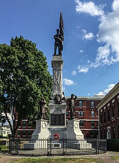
A Civil War Memorial stands in downtown Webster, Massachusetts in front of the town hall as one part of a series of war monuments called Honor Court. This memorial was dedicated in 1907 and consists of a central tower with a bronze statue of a soldier on top. Four other bronze statues of soldiers stand at each of the four corners: an infantryman, artilleryman, cavalryman, and sailor.
Bates Island is a forested and uninhabited island located in Lake Chaubunagungamaug in Webster, Massachusetts.
Childs Island is a small heavily forested island located north of the Stop River in the wetlands of Medfield Rhododendrons in Medfield, Massachusetts.
Cemetery Island is a heavily forested island located in the Wachusett Reservoir in Clinton, Massachusetts. The island's name came from its being part of an old burial ground that was flooded by the creation of the reservoir; 3,816 bodies were removed and reinterred in St. John's Cemetery in Lancaster, Massachusetts.
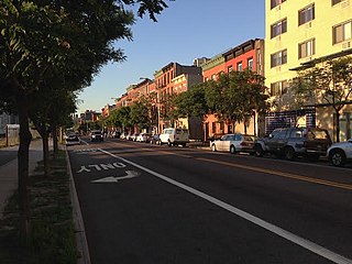
The Columbia Street Waterfront District is a neighborhood in the borough of Brooklyn in New York City on the Upper New York Bay waterfront between Cobble Hill and Red Hook and situated on the western side of the Brooklyn–Queens Expressway (BQE). The neighborhood is locally governed by Brooklyn Community Board 6. The neighborhood was formed in 1957 when the newly built BQE effectively cut Columbia Street off from Carroll Gardens and Cobble Hill, its two adjacent neighborhoods. The district, once an area that was blighted by empty storefronts, was further emptied of tenants by an accident, while a sewer line was being repaired, that caused the death of a construction worker and the demolition of 33 buildings. By 1984, an urban renewal project was completed, as well as a brand-new street, houses along which sold out quickly.
Farmville is an unincorporated community in Gordon County, in the U.S. state of Georgia.
Greenwood is an unincorporated community in Jefferson Township, Wells County, in the U.S. state of Indiana.
Wortham is a census-designated place in St. Francois County, in the U.S. state of Missouri. As of 2010, Wortham's population is 279 making the growth rate 4.5%.
Big Creek is an unincorporated community in Texas County, in the U.S. state of Missouri. The community was located along Big Creek, approximately 2.5 miles south of Yukon and one-half mile east of Missouri Route 137. The Big Creek school was south of the creek and the Big Creek church was about one-half mile north along a county road.
References
- ↑ "Cobble Island - Maps, Driving Directions & Local Area Information" . Retrieved 5 March 2014.CS1 maint: discouraged parameter (link)
- ↑ "Cobble Island". Geographic Names Information System . United States Geological Survey . Retrieved 17 March 2014.CS1 maint: discouraged parameter (link)
Coordinates: 42°02′03″N71°50′40″W / 42.03417°N 71.84444°W
| | This Worcester County, Massachusetts geography–related article is a stub. You can help Wikipedia by expanding it. |