Cow Island is a 26-acre (11 ha) island in Casco Bay, Maine, off Great Diamond Island, about 3 miles (4.8 km) northeast of downtown Portland, and is part of the Town of Long Island in Cumberland County. A non-profit youth development organization called Rippleffect owns the island and has the responsibility to protect the island's natural ecosystem as well as the island's public access.

Woziwoda is a village in the administrative district of Gmina Tuchola, within Tuchola County, Kuyavian-Pomeranian Voivodeship, in north-central Poland. It lies approximately 10 kilometres (6 mi) north-east of Tuchola and 62 km (39 mi) north of Bydgoszcz.
Klocek is a village in the administrative district of Gmina Tuchola, within Tuchola County, Kuyavian-Pomeranian Voivodeship, in north-central Poland. It lies approximately 12 kilometres (7 mi) north-east of Tuchola and 64 km (40 mi) north of Bydgoszcz.

Xaşı is a village in the Quba Rayon of Azerbaijan. The village forms part of the municipality of Qonaqkənd.
Nobela is a village in the administrative district of Gmina Warta, within Sieradz County, Łódź Voivodeship, in central Poland. It lies approximately 6 kilometres (4 mi) south-east of Warta, 9 km (6 mi) north-west of Sieradz, and 55 km (34 mi) west of the regional capital Łódź.
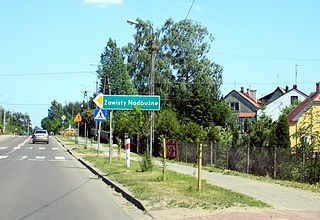
Zawisty Nadbużne is a village in the administrative district of Gmina Małkinia Górna, within Ostrów Mazowiecka County, Masovian Voivodeship, in east-central Poland.
Koszelew is a village in the administrative district of Gmina Gąbin, within Płock County, Masovian Voivodeship, in east-central Poland. It lies approximately 3 kilometres (2 mi) west of Gąbin, 18 km (11 mi) south of Płock, and 92 km (57 mi) west of Warsaw.
Krzyżno is a village in the administrative district of Gmina Sośnie, within Ostrów Wielkopolski County, Greater Poland Voivodeship, in west-central Poland. It lies approximately 7 kilometres (4 mi) north-east of Sośnie, 16 km (10 mi) south of Ostrów Wielkopolski, and 113 km (70 mi) south-east of the regional capital Poznań.
Jęczewo is a village in the administrative district of Gmina Gniewino, within Wejherowo County, Pomeranian Voivodeship, in northern Poland. It lies approximately 3 kilometres (2 mi) south of Gniewino, 18 km (11 mi) north-west of Wejherowo, and 54 km (34 mi) north-west of the regional capital Gdańsk.

Cella is an unincorporated community in Fresno County, California. It is located on the Atchison, Topeka and Santa Fe Railroad 3.5 miles (5.6 km) southeast of Centerville, at an elevation of 367 feet.
Mattei is an unincorporated community in Fresno County, California. It is located on the Atchison, Topeka and Santa Fe Railroad 2.5 miles (4 km) east-northeast of Malaga, at an elevation of 315 feet.
Creekside is a hamlet in the town of Boston in Erie County, New York, United States.

Lindbergh is a hamlet in central Alberta, Canada within the County of St. Paul No. 19. It is located approximately 17 kilometres (11 mi) east of Highway 41 and 77 kilometres (48 mi) northwest of Lloydminster.
KZKR is a radio station airing a classic rock format licensed to Jonesville, Louisiana, broadcasting on 105.1 MHz FM. The station is owned by First Natchez Radio Group Inc., and is an affiliate of the syndicated Pink Floyd program "Floydian Slip."
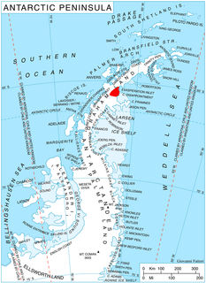
Belogradchik Glacier is the 14 km long and 5.6 km wide glacier in southern Aristotle Mountains on Oscar II Coast in Graham Land, Antarctica situated south of Jeroboam Glacier and west of Ambergris Glacier. It is draining the southeast slopes of Madrid Dome, and flowing southeastwards to join Flask Glacier east of Mount Fedallah.
Church Hill is a census-designated place located in Armagh and Brown Townships in Mifflin County in the state of Pennsylvania. It is located north of the borough of Burnham. As of the 2010 census the population was 1,627 residents.
Strodes Mills is a census-designated place located in Oliver and Granville Townships in Mifflin County in the state of Pennsylvania. It is located along U.S. Route 522 in central Mifflin County, between the community of McVeytown and the borough of Lewistown. As of the 2010 census the population was 757 residents.

Hollenbeck Canyon Wildlife Area is located near Jamul in California. The former cattle ranch was designated a wildlife area in 2001, and forms a wildlife corridor between Otay Mountain Wilderness and Jamul Mountains under the protection of the California Department of Fish and Wildlife. The area is open to the public for activities including hunting, equestrian use, hiking, mountain-biking, and (hunting) dog training.

Zbazhdi is a village in Municipality of Struga, Macedonia.


