Charlestown Neck

Last updated
Charlestown Battle Map, 1775 CharlestownBattleMap1775.jpg
Charlestown Battle Map, 1775

The Charlestown Neck was an isthmus connecting the formerly independent city of Charlestown, Massachusetts to the mainland at present-day Sullivan Square in Middlesex County. When Charlestown was first settled by British colonists it was surrounded on nearly all sides by water. Only a small strip of land called "the neck" connected what is now Charlestown to what would become Somerville.

<i>Isthmus</i> Narrow strip of land connecting two larger land areas

An isthmus is a narrow piece of land connecting two larger areas across an expanse of water by which they are otherwise separated. A tombolo is an isthmus that consists of a spit or bar, and a strait is the sea counterpart of an isthmus.

Charlestown, Boston Neighborhood of Boston in Massachusetts, United States

Charlestown is the oldest neighborhood within the city of Boston, Massachusetts, United States. Originally called Mishawum by the Massachusett tribe, it is located on a peninsula north of the Charles River, across from downtown Boston, and also adjoins the Mystic River and Boston Harbor waterways. Charlestown was laid out in 1629 by engineer Thomas Graves, one of its earliest settlers, in the reign of Charles I of England. It was originally a separate town and the first capital of the Massachusetts Bay Colony.

Middlesex County, Massachusetts County in Massachusetts

Middlesex County is a county in the Commonwealth of Massachusetts, in the United States. As of 2018, the estimated population was 1,614,714, making it the 22nd most populous county in the United States, and the most populous county in both Massachusetts and New England. As part of the 2010 national census, the Commonwealth's mean center of population for that year was geo-centered in Middlesex County, in the town of Natick at. Middlesex County is included in the Census Bureau’s Boston–Cambridge–Newton, MA–NH Metropolitan Statistical Area.

Contents

History

As with Boston's founding on the Shawmut Peninsula, Charlestown was originally settled on a small peninsula (Indian name Mishawum) accessible by land only via a small isthmus. [1] While Charlestown was then largely separated from the mainland by an inlet of the Charles River later called Prison Point Bay, and by what was later called the Miller's River, these bodies of water have since been completely obscured by landfill and land reclamation over the late 19th and early 20th centuries. [2] [3]

Boston State capital of Massachusetts, U.S.

Boston is the capital and most populous city of the Commonwealth of Massachusetts in the United States, as well as the 21st most populous city in the United States. The city proper covers 48 square miles (124 km2) with an estimated population of 694,583 in 2018, making it also the most populous city in New England. Boston is the seat of Suffolk County as well, although the county government was disbanded on July 1, 1999. The city is the economic and cultural anchor of a substantially larger metropolitan area known as Greater Boston, a metropolitan statistical area (MSA) home to a census-estimated 4.8 million people in 2016 and ranking as the tenth-largest such area in the country. As a combined statistical area (CSA), this wider commuting region is home to some 8.2 million people, making it the sixth most populous in the United States.

Shawmut Peninsula peninsula

Shawmut Peninsula is the promontory of land on which Boston, Massachusetts was built. The peninsula, originally a mere 789 acres (3.19 km2) in area, more than doubled in size due to land reclamation efforts that were a feature of the history of Boston throughout the 19th century.

Charles River river in Massachusetts, United States

The Charles River is an 80-mile-long (129 km) long river in eastern Massachusetts. From its source in Hopkinton the river's mouth is northeast of its headwaters, though it follows a highly meandering route, doubling back on itself several times and traveling through 23 cities and towns before reaching the Atlantic Ocean at Boston. The Native-American name for the Charles River was Quinobequin, meaning "meandering".

From the 1630s until the early 1800s the residential and commercial life of Charlestown was mostly focused on Boston Harbor. The Charlestown Peninsula grew into a major port community over the 18th century, and the inhabitants had little use for the rural area "beyond the neck", aside from occasional agricultural pursuits or quarrying. The completion of the 27 mile (43 km) Middlesex Canal in 1803 shifted Charlestown’s attention to its western hinterlands. The canal terminated at the Charlestown Neck, which precipitated the Neck's transition into a regional transportation hub. This would remain the case for at least another two centuries. [4]

Middlesex Canal Canal in Massachusetts, United States of America

The Middlesex Canal was a 27-mile (44-kilometer) barge canal connecting the Merrimack River with the port of Boston. When operational it was 30 feet wide, and 3 feet deep, with 20 locks, each 80 feet long and between 10 and 11 feet wide. It also had eight aqueducts.

Although the peninsula and the mainland were technically one city, by the 1830s the rural farmers making a living "beyond the neck" had begun to resent their industrializing counterparts (and vice versa). Political separation took place in 1842, with Somerville becoming its own township. However, it was the railroads that would eventually doom the Charlestown Neck. Over the second half of the 19th century, industry would flourish throughout the region, necessitating the construction of good transportation infrastructure and reliable distribution networks. Railroads saw the Neck as a key transit point for manufactured goods produced in the Merrimack Valley, with easy access to Boston, Charlestown and Cambridge markets.

Merrimack Valley region in Massachusetts and New Hampshire

The Merrimack Valley is a bi-state region along the Merrimack River in the U.S. states of New Hampshire and Massachusetts. The Merrimack is one of the larger waterways in the New England region and has helped define the livelihood and culture of those living along it since native times.

By the 1870s Sullivan Station was under construction and railroads began filling in area wetlands in order to lay down tracks. Industrialists leveled Cobble Hill in Brickbottom (one of Somerville's original "seven hills") to fill the wetlands. Additionally, meat-packing was taking off at the time, and slaughterhouses would dispose of waste directly into water. [5] Between 1855 and 1869, the Miller's River district became "malodorous and unenviable" [6] on account of the slaughterhouses.

In the late 19th century, Miller's River had become a dumping ground such that the stench and resulting health problems prompted some of the first public health-based anti-pollution environmental laws in Massachusetts; they are seen as a precedent for later environmental laws that would be introduced throughout the United States. [7] The inaccessible and degraded industrial landscape around Miller's River and along the lower Charles River basin became known during the late 19th and the 20th centuries as "the Lost Half-Mile". The City of Cambridge saw Miller's River as a health risk and ordered it filled. [8]

By 1886, the open water and wetlands between Charlestown and Cambridge had largely been filled in as factories sprang up in the area. Today, the Charlestown Neck and associated bodies of water are non-existent above ground. [9]

See also

Related Research Articles

Medford, Massachusetts City in Massachusetts, United States

Medford is a city 6.7 miles northwest of downtown Boston on the Mystic River in Middlesex County, Massachusetts, United States. In the 2010 U.S. Census, Medford's population was 56,173. It is home to Tufts University, which has its campus along the Medford and Somerville border. In 2017, Medford’s population grew up to 57,797 residents.

Somerville, Massachusetts City in Massachusetts, United States

Somerville is a city located directly to the northwest of Boston, and east of Cambridge, in Middlesex County, Massachusetts, United States. As of 2010, the United States Census listed the city with a total population of 75,754 people, making it the most densely populated municipality in New England. As of 2010, it was the 16th most densely populated incorporated municipality in the country. Somerville was established as a town in 1842, when it was separated from Charlestown. In 2006, the city was named the best-run city in Massachusetts by the Boston Globe. In 1972, in 2009, and again in 2015, the city received the All-America City Award. It is home to Tufts University, which has its campus along the Somerville and Medford border.

Battle of Bunker Hill Early battle of the American Revoluntionary War

The Battle of Bunker Hill was fought on June 17, 1775, during the Siege of Boston in the early stages of the American Revolutionary War. The battle is named after Bunker Hill in Charlestown, Massachusetts, which was peripherally involved in the battle. It was the original objective of both the colonial and British troops, though the majority of combat took place on the adjacent hill which later became known as Breed's Hill.

Union Square is a neighborhood in the southeastern part of Somerville, Massachusetts. It is centered on Union Square proper, which is located at the intersection of Washington Street, Webster Avenue, and Somerville Avenue.

Bunker Hill Monument United States historic place

The Bunker Hill Monument was erected to commemorate the Battle of Bunker Hill, which was among the first major battles between British and Patriot forces in the American Revolutionary War, fought there June 17, 1775. The 221-foot granite obelisk was erected between 1825 and 1843 in Charlestown, Massachusetts, with granite from nearby Quincy conveyed to the site via the purpose-built Granite Railway, followed by a trip by barge. There are 294 steps to the top.

Grand Junction Railroad and Depot Company railway company

The Grand Junction Railroad is an 8.55-mile (13.76 km) long railroad in the Boston, Massachusetts, area, connecting the railroads heading west and north from Boston. Most of it is still in use, carrying scrap either inbound or outbound to the Schnitzer scrap yard on the Everett waterfront or freight to the Chelsea Produce Market, and non-revenue transfers of Amtrak and MBTA passenger equipment between the lines terminating at North Station and South Station. The line is also notable for its railroad bridge over the Charles River that passes under the Boston University Bridge between Boston and Cambridge, Massachusetts.

Sullivan Square station Boston MBTA subway station

Sullivan Square is a rapid transit station in Boston, Massachusetts. It serves the MBTA's Orange Line, and is also a major bus transfer point. It is located just west of the Sullivan Square traffic circle in the Charlestown neighborhood, adjacent to East Somerville. The modern subway station was built in 1975, and replaced an earlier Charlestown Elevated station established in 1901.

Community College station MBTA subway station

Community College is a rapid transit station in Boston, Massachusetts. It serves the MBTA Orange Line. It is located in the Charlestown neighborhood off Austin Street near New Rutherford Avenue (MA-99), under the double-decked elevated structure carrying Interstate 93 to the Zakim Bunker Hill Bridge. The station is named for the adjacent Bunker Hill Community College, the main population the station serves.

East Cambridge, Cambridge, Massachusetts neighborhood of Cambridge, Massachusetts, United States

East Cambridge is a neighborhood of Cambridge, Massachusetts. Referred to in modern times as Area 1, East Cambridge is bounded by the Charles River and the Charlestown neighborhood of Boston on the east, the Somerville border on the north, Broadway and Main Street on the south, and the railroad tracks on the west. Most of the streets form a grid aligned with Cambridge Street, which was laid out to directly connect what is now the Charles River Dam Bridge with what in 1809 was the heart of Cambridge, Harvard Square. The northern part of the grid is a roughly six by eight block residential area. Cambridge Street itself is retail commercial, along with Monsignor O'Brien Highway, the Twin Cities Plaza strip mall, and the enclosed Cambridgeside Galleria. Lechmere Square is the transportation hub for the northern side. The southern half of the grid is largely office and laboratory space for hundreds of dot-com companies, research labs and startups associated with MIT, biotechnology firms including Genzyme and Biogen, the Athenaeum Press Building, light industry, an NRG Energy power station, and various small businesses. This half of the neighborhood is generally identified with Kendall Square. Along the waterfront are several hotels and taller apartment buildings.

The Haymarket North Extension is a section of the Massachusetts Bay Transportation Authority's rapid transit Orange Line which currently constitutes the northern section of the line. It runs from North Station through an underground crossing of the Charles River, then along the Haverhill Line right-of-way to Oak Grove station in Malden, Massachusetts. Built to replace the Charlestown Elevated and originally intended to be extended as far as Reading, it opened in stages between 1975 and 1977.

Assembly Square human settlement in Massachusetts, United States of America

Assembly Square is a neighborhood in Somerville, Massachusetts. It is located along the west bank of the Mystic River, bordered by Ten Hills and Massachusetts Route 28 to the north and the Charlestown neighborhood of Boston to the south. The district's western border runs along Interstate 93. Located 2.5 miles (4.0 km) from downtown Boston, the 143 acres (580,000 m2) parcel is named for a former Ford Motor Company plant that closed in 1958.

The Medford Turnpike is a road mostly in modern-day Somerville, Massachusetts, United States, now known as Mystic Avenue. It was laid out in 1803 as a result of the 1786 Charles River Bridge from Charlestown to Boston. In historic terms, it ran from Medford Center to Charlestown Neck. It is currently designated to be part of Massachusetts Route 38.

Leonard B. Chandler American politician

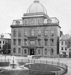
Leonard Blanchard Chandler was a Massachusetts businessman and politician who served in the 1917 Massachusetts Constitutional Convention, in both branches of the Massachusetts legislature, both branches of the city council and as the twelfth Mayor of Somerville, Massachusetts.

Sullivan Square human settlement in Massachusetts, United States of America

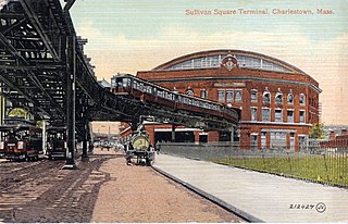
Sullivan Square is a traffic circle located in the Charlestown neighborhood of Boston, Massachusetts. The MBTA's Sullivan Square station is located to the west of the square. Adjacent to the East Somerville area of Somerville, Sullivan Square is named after James Sullivan, an early 19th-century Governor of Massachusetts. In the early 2000s, the Sullivan Square Overpass was dismantled, which left a stub approach to Route 99.

Millers River (Middlesex) river in United States of America

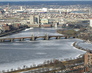
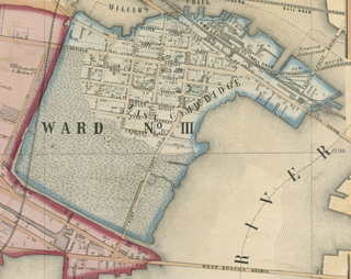
Millers River was a river in Middlesex County, Massachusetts. It has since mostly been obscured by landfill and "made land". The small remaining estuary is a remnant of wetlands and open water that once divided Cambridge from Charlestown, Massachusetts.

East Somerville station planned light rail station in Somerville, Massachusetts

East Somerville is a planned light rail station on the MBTA Green Line "D" Branch in Somerville, Massachusetts. The station will consist of one island platform, which will serve the "D" Branch's two tracks.

The following is a timeline of the history of Somerville, Massachusetts, USA.

References

  1. 1775 map detail Retrieved 27 December 2013]
  2. Mapping Boston, Krieger, Alex, ed., MIT Press 1999, pp. 16-19.
  3. "Sullivan Square: Part 1 of 3". Somerville Development Forum. Somerville Development Forum. Retrieved 6 December 2013.
  4. Adams Drake, Samuel (1880). History of Middlesex County, Massachusetts: Containing Carefully Prepared Histories of Every City and Town in the County, Volume 2 (Google eBook). Nabu Press. Archived from the original on 5 January 2014. Retrieved 7 December 2013.
  5. "Trends in Somerville: Land Use Technical Report" (PDF). somervillema.gov. City of Somerville Office of Strategic Planning and Community Development. May 2011. Archived from the original (PDF) on 13 December 2013. Retrieved 11 December 2013.
  6. Edward A. Samuels, ed. (1897). Somerville , Past and Present: An Illustrated Historical Souvenir. Henry H. Kimball. Samuels & Kimball. p. 134.
  7. "Inventing the Charles River". Archived from the original on 2012-10-11.
  8. "Transforming the Lost Half-Mile". Archived from the original on 2014-02-16. Retrieved 2013-12-14.
  9. James C. O'Connell (2013). The Hub's Metropolis: Greater Boston's Development from Railroad Suburbs to Smart Growth. MIT Press. pp. 116–. ISBN   978-0-262-01875-3.

Further reading

Coordinates: 42°23′1.4″N71°4′20.1″W / 42.383722°N 71.072250°W / 42.383722; -71.072250