Related Research Articles

Rock County is a county in the U.S. state of Nebraska. As of the 2010 United States Census, the population was 1,526. Its county seat is Bassett.

Nahant is a town in Essex County, Massachusetts, United States. The population was 3,334 at the 2020 census, which makes it the smallest municipality by population in Essex County. With just 1.0 square mile (2.7 km2) of land area, it is the smallest municipality by area in the state. It is primarily a residential community. The town is situated on peninsula consisting of two near-islands connected to the mainland by a narrow sandy isthmus traversed by a single causeway known as "Nahant Road". Numerous tourist beaches line the shores, with the most popular being the so-called "Long Beach" and "Short Beach" along the eastern side of the causeway.

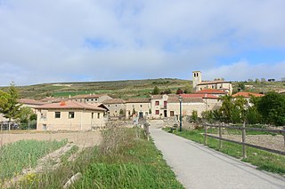
Villahoz is a village and municipality in the Province of Burgos, Spain. The village is in the wine region known as Ribera del Arlanza, 15 km from Lerma.

Green Island, also known as North Brewster Island, is a rocky outer island in the Boston Harbor Islands National Recreation Area, to the north of Calf Island and Hypocrite Channel. The island has a permanent size of 2.5 acres (10,000 m2), plus an intertidal zone of a further 15 acres (61,000 m2), and is exposed from the east and northeast with little soil or plant life. The island is named after Joseph Green, a well-known merchant, who owned the island during Colonial times.
Barrel Rock is a small barren rock within the edge of Cohasset Harbor in Cohasset, Massachusetts, USA. The rock is north of Sutton Rocks, northwest of Quarry Point, south of Chittenden Rock, and east of Brush Island. It is located at 42°15′32″N70°47′6″W
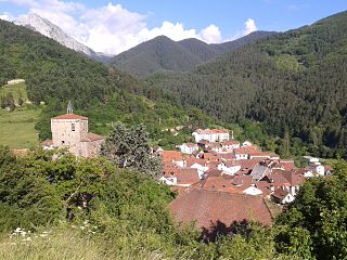
Guesálaz is a town and municipality located in the province and autonomous community of Navarre, northern Spain.
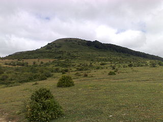
Isaba is a town and municipality located in the province and autonomous community of Navarre, northern Spain. Is the main town of the Roncal valley and is sited in the Pyrenees of the autonomous Region.
Massachusetts's 6th congressional district is located in northeastern Massachusetts. It contains most of Essex County, including the North Shore and Cape Ann, as well as part of Middlesex County. It is represented by Seth Moulton, who has represented the district since January 2015. The shape of the district went through minor changes effective from the elections of 2012 after Massachusetts congressional redistricting to reflect the 2010 census. The towns of Tewksbury and Billerica were added, along with a small portion of the town of Andover.

Hornillos del Camino is a municipality located in the province of Burgos, Castile and León, Spain. According to the 2004 census (INE), the municipality has a population of 70 inhabitants.

Mazuela is a municipality and town located in the province of Burgos, Castile and León, Spain. According to a 2008 estimate (INE), the municipality has a population of 97 inhabitants. It is about 27 kilometers from Burgos, in the area southwest of the Burgos Province.
Susinos del Páramo is a municipality and town located in the province of Burgos, Castile and León, Spain. According to the 2004 census (INE), the municipality has a population of 115 inhabitants.

North Shore Technical High School was a public application-type high school located in the town of Middleton in the U.S. state of Massachusetts under the North Shore Regional Vocational School District. It served ninth through twelfth grade students from 16 communities all on the North Shore. They included Beverly, Boxford, Danvers, Essex, Gloucester, Hamilton, Lynnfield, Manchester-by-the-Sea, Marblehead, Middleton, Nahant, Rockport, Salem, Swampscott, Topsfield, and Wenham. NST was the home to their logo and mascot, the bulldog.

Lynn Shore Reservation is a protected coastal reservation in the city of Lynn, Massachusetts. It includes 22 acres (8.9 ha) of beaches and recreational areas. From north to south, King's Beach, Red Rock Park and Lynn Beach are located along Lynn Shore Drive and Nahant Bay, a small bay of the Atlantic. The reservation shares athletic fields with Nahant Beach Reservation in the area around Nahant Rotary, a traffic circle at its southern end.
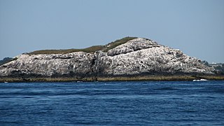
Egg Rock in Nahant Bay near Nahant, Massachusetts is a small (3-acre) island at 42.4333°N 70.8978°W. It was formerly the site of a lighthouse known as Egg Rock Light but now is owned by the state of Massachusetts as a bird sanctuary. Egg Rock can be seen clearly from the coasts of Nahant, Swampscott, and Lynn. Egg Rock is the setting for Sylvia Plath's poem "Suicide off Egg Rock", and also appears in her novel, The Bell Jar.
German submarine U-418 was a Type VIIC U-boat of Nazi Germany's Kriegsmarine during World War II.
Broad Sound is a bay on the Massachusetts coast north of Boston. It lies on the west of Massachusetts Bay, between Nahant and Deer Island; Lynn harbor is at its north end. The main channel of Boston Harbor empties into the sound.
Castle Rock is a barren, uninhabited island located in Nahant Bay in Nahant, Massachusetts.
Nahant Bay is an Atlantic Ocean bay, fronted by Swampscott, Lynn, and Nahant, Massachusetts. Egg Rock is located in the Nahant Bay.
HMS LST-418 was a United States Navy LST-1-class tank landing ship that was transferred to the Royal Navy during World War II. As with many of her class, the ship was never named. Instead, she was referred to by her hull designation.
References
Coordinates: 42°25′05″N70°55′01″W / 42.418°N 70.917°W
| | This Essex County, Massachusetts geography–related article is a stub. You can help Wikipedia by expanding it. |