
North Westport is a census-designated place (CDP) in the town of Westport in Bristol County, Massachusetts, United States. The population was 4,571 at the 2010 census.

Westport is a town in Bristol County, Massachusetts, United States. The population was 16,339 at the 2020 census.
Block Island Sound is a strait in the open Atlantic Ocean, approximately 10 miles (16 km) wide, separating Block Island from the coast of mainland Rhode Island in the United States. On the west, it extends to Montauk Point on the eastern tip of Long Island, as well as Plum Island, Gardiners Island, and Fishers Island, all in the state of New York.

The Dog River is a river in Mobile County, Alabama. The Dog River watershed drains more than 90 square miles (230 km2). The river is about 8 miles (13 km) long and is influenced by tides. It originates at 30.64158°N 88.09666°W within the city of Mobile. It discharges into Mobile Bay, a tidal estuary on the northern Gulf of Mexico, at 30.56491°N 88.08833°W near Hollinger's Island. It was named by the original French colonists as the Riviere Au Chien, which can be translated into English as Dog River.

The Normand Edward Fontaine Bridge is a 1,025 feet (312 m)-long bascule bridge at 41.517258°N 71.06799°W in Westport, Massachusetts, USA. Two lanes of Route 88 pass over the bridge from Westport Point and Wood Point in the Westport Point section of town to the Horseneck Beach State Reservation, connecting with Cherry & Webb Lane and, eventually, John Reed Road when Route 88 officially ends 0.3 miles south of the bridge's southern end.
Route 88 is a 11.30-mile-long (18.19 km) north–south state highway in the town of Westport in southeastern Massachusetts. At just over 11 miles, it is the longest Massachusetts state route to be situated in only one town. It begins at John Reed Road and ends at an interchange with I-195.
Bar Rock is a small barren rock within Rhode Island Sound, in Westport, Massachusetts, USA. The rock is off the connector of Horseneck and Gooseberry Neck at the Horseneck Beach State Reservation. It's just north of the state reservation's campground.

Anaho Island is a rocky island in Pyramid Lake, and located on the Pyramid Lake Indian Reservation, Washoe County, in the U.S. state of Nevada.

The Westport River lies between Narragansett Bay and Buzzards Bay in Westport, Massachusetts.
Pelican Island is an island in the Barnegat Bay wholly located in Ocean County, New Jersey. It is accessible from Toms River and Seaside Heights via the Tunney and Mathis Bridges on New Jersey Route 37. It is part of Toms River and Berkeley Township.

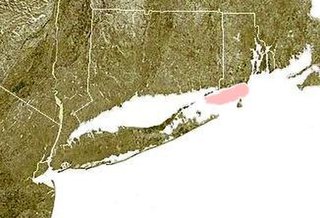
The Norwalk Islands are a chain of more than 25 islands amid partly submerged boulders, reefs and mudflats along a six-mile (10 km) stretch and mostly about a mile off the coast of Norwalk, Connecticut, and southwest Westport, Connecticut, in Long Island Sound.
Inchtavannach, is one of the larger islands in Loch Lomond.
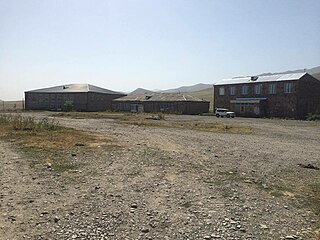
Katnarat is a town in the Lori Province of Armenia. The town was originally a sovkhoz.

Daleville is a small village located in Covington Township in Lackawanna County, Pennsylvania, United States.

Gooseberry Island is a small, historical island off the coast of Westport in Bristol County, Massachusetts, United States. The island is a part of Westport, and is the town's most southern point.
Big Pine Island is a forested island located in the East Branch of the Westport River in Westport, Massachusetts.
West Buffalo is a ghost town in Williams County, in the U.S. state of Ohio.
Stanton is an unincorporated community in Jefferson County, in the U.S. state of Pennsylvania.
This page is based on this
Wikipedia article Text is available under the
CC BY-SA 4.0 license; additional terms may apply.
Images, videos and audio are available under their respective licenses.