Deerfield River is a river that runs for 76 miles (122 km) from southern Vermont through northwestern Massachusetts to the Connecticut River. The Deerfield was historically influential in the settlement of western Franklin County, Massachusetts, and its namesake town. The Deerfield River is the Connecticut River's second longest tributary in Massachusetts, 2.1 miles (3.4 km) shorter than the Metropolitan Springfield's Westfield River.

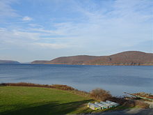
Lake Memphremagog is a fresh water glacial lake located between Newport, Vermont, United States and Magog, Quebec, Canada. The lake spans both Quebec and Vermont, but is mostly in Quebec. Most of the watershed that feeds the lake is located in Vermont, and is a source for accumulated phosphorus, sediments and other pollutants. Cleanup efforts since the late 1980s have improved the water quality. The lake furnishes potable (drinking) water for 200,000 people.

Otter Brook is a 13.2 mile long river located in southwestern New Hampshire in the United States. It is a tributary of The Branch of the Ashuelot River, itself a tributary of the Connecticut River, which flows to Long Island Sound.

Tarbell Brook is a 10.1-mile-long (16.3 km) stream located in southwestern New Hampshire and northern Massachusetts in the United States. It is a tributary of the Millers River, itself a tributary of the Connecticut River, which flows to Long Island Sound.
The Spicket River is a 17.7-mile-long (28.5 km) river located in New Hampshire and Massachusetts in the United States. It is a left tributary of the Merrimack River, part of the Gulf of Maine watershed. It is sometimes spelled "Spickett".

The Quaboag River is a 25.7-mile-long (41.4 km) river in Massachusetts that heads at Quaboag Pond in Brookfield at an elevation of 594 feet (181 m) above sea level. It flows west to the village of Three Rivers, Massachusetts, at an elevation of 290 feet (88 m).

The Millers River is a 52.1-mile-long (83.8 km) river in northern Massachusetts, originating in Ashburnham and joining the Connecticut River just downstream from Millers Falls, Massachusetts. The river was formerly known as Paquag or Baquag, a Nipmuc word meaning "clear water". Sections of the river are used for whitewater kayaking, and a section upriver is popular with flatwater racers.
The Burnshirt River is a 12.9-mile-long (20.8 km) stream in Worcester County, Massachusetts. It is a tributary of the Ware River, draining ultimately into the Connecticut River and thence the Long Island Sound.
The East Delaware Tunnel is a 25-mile (40 km) aqueduct in the New York City water supply system. Located in the
Catskill Mountains of New York State, it was constructed within a six-year period between 1949 and 1955 to transport drinking water from the Pepacton Reservoir to the Rondout Reservoir. The tunnel begins near the former site of Pepacton, New York, and ends near the former site of Eureka, New York, passing through Delaware County, Sullivan County and Ulster County. The tunnel has a maximum transmission capacity of 500 million US gallons (1,900,000 m3) per day and was constructed at a width of 11 feet (3.4 m).
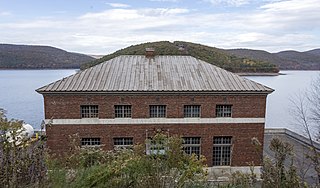
Bear Swamp Generating Station or Jack Cockwell Station is a pumped-storage hydroelectric underground power station that straddles the Deerfield River in Rowe and Florida, Massachusetts. It is one of many hydroelectric facilities along the river, giving that waterway the nickname of "the hardest working river in the county".
The Broad Brook Canal is a water-supply canal feeding the Springfield Reservoir in Ludlow, Massachusetts, a public water supply for the city of Springfield, Massachusetts. Its northern segment is also known as the Jabish Canal.

Chapel Brook of Franklin County, Massachusetts is a tributary of the South River and the name of a 173-acre (70 ha) open space preserve located along the brook. The brook, est. 3.79 mi (6 km) long, is located in southeast Ashfield and southwest Conway. It drains into Poland Brook, thence into the South River, the Deerfield River, the Connecticut River, and Long Island Sound. The Chapel Brook reservation, managed by the non-profit conservation organization The Trustees of Reservations, is located in Ashfield and contains Chapel Falls, a series of three waterfalls on Chapel Brook, measuring 10 feet, 15 feet and 20 feet high; and Pony Mountain est. 1,400 feet, a 100-foot (30 m) open granite cliff face and popular recreational rock climbing site.

Stony Brook is a stream largely running through Weston, Massachusetts, then forming the Weston/Waltham boundary, and emptying into the Charles River across from the Waltham/Newton boundary. It has two tributaries, Cherry Brook and Hobbs Brook, and its watershed includes about half of Lincoln and Weston as well as parts of Lexington and Waltham. Since 1887, it has been the water supply for Cambridge.
Beardsley Canal is an irrigation canal in Kern County, California. It originates at the Kern River, east of Gordon's Ferry and just west of the First Point of Measurement. It is the first diversion from the river in the San Joaquin Valley for agriculture irrigation. It terminates at reservoirs located in Famoso, just east of SR 99.

Harriman Dam is a hydroelectric dam in Windham County, Vermont in the town of Whitingham. The water from the dam flows through a penstock to a power generation plant in the adjacent town of Readsboro.
Northfield Mountain is a pumped-storage hydroelectric plant and reservoir located on and under the similarly named Northfield Mountain in Erving and Northfield, Massachusetts. It is currently owned by FirstLight Power Resources, which purchased the facility from Northeast Utilities in 2006.

Ashley Reservoir, a Class II hazard reservoir, is the secondary drinking supply for the city of Holyoke, Massachusetts. The reservoir, consisting of Wright Pond and Ashley Pond, has an impound capacity of more than 795 million gallons of water and a safe yield of 2.1 million gallons of water per day.