
Ipswich is a coastal town in Essex County, Massachusetts, United States. The population was 13,785 at the 2020 census. Home to Willowdale State Forest and Sandy Point State Reservation, Ipswich includes the southern part of Plum Island. A residential community with a vibrant tourism industry, the town is famous for its clams, celebrated annually at the Ipswich Chowderfest, and for Crane Beach, a barrier beach near the Crane estate. Ipswich was incorporated as a town in 1634.

The Town of Southold is one of ten towns in Suffolk County, New York, United States. It is located in the northeastern tip of the county, on the North Fork of Long Island. The population was 23,732 at the 2020 census. The town also contains a hamlet named Southold, which was settled in 1640.

Western Port, commonly but unofficially known as Western Port Bay, is a large tidal bay in southern Victoria, Australia, opening into Bass Strait. It is the second largest bay in the state. Geographically, it is dominated by two large islands; French Island and Phillip Island. At the time it was renamed, its position was west of other known ports and bays, but Western Port has become something of a misnomer as it lies just to the east of the larger Port Phillip and the city of Melbourne. It is visited by Australian fur seals, whales and dolphins, as well as many migratory waders and seabirds. It is listed under the Ramsar Convention as a wetland of international significance.
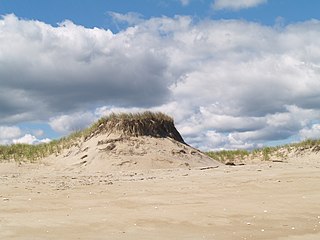
Plum Island is a barrier island located off the northeast coast of Massachusetts, north of Cape Ann, in the United States. It is approximately 11 miles (18 km) in length. The island is named for the wild beach plum shrubs that grow on its dunes, but is also famous for the purple sands at high tide, which get their color from tiny crystals of pink pyrope garnet. It is located in parts of four municipalities in Essex County. From north to south they are the city of Newburyport, and the towns of Newbury, Rowley, and Ipswich.
The Bass Rock, also known as "the Bass", is a distinctive island off the coast of East Lothian, Scotland. Scottish emigrants named three islands in the United States after the Bass Rock: Bass Rock may also refer to:
Badgers Rock is a small barren rock within the Merrimack River, in Salisbury, Massachusetts, United States. The rock is just south of the light campground area of the Salisbury Beach State Reservation and north of Plum Island Point on Plum Island in Newburyport.

Nacton is a village and civil parish in the East Suffolk district of Suffolk, England. The parish is bounded by the neighbouring parishes of Levington to the east and Bucklesham in the north. It is located between the towns of Ipswich and Felixstowe.
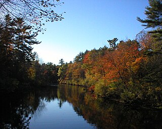
Ipswich River is a small river in northeastern Massachusetts, United States. It held significant importance in early colonial migrations inland from the ocean port of Ipswich. The river provided safe harborage at offshore Plum Island Sound to early Massachusetts subsistence farmers, who were also fishermen. A part of the river forms town boundaries and divides Essex County, Massachusetts on the coast from the more inland Middlesex County. It is 35 miles (56 km) long, and its watershed is approximately 155 square miles (401 km2), with an estimated population in the area of 160,000 people.

Sandy Point State Reservation is a coastal Massachusetts state park located in the town of Ipswich at the southern tip of Plum Island. The reservation is managed by the Department of Conservation and Recreation and is an important nesting area for the piping plover and the least tern. Access to the reservation is through the adjoining Parker River National Wildlife Refuge.
The Egypt River is a stream in Ipswich, Massachusetts, United States.

The Rowley River is a small river between Ipswich and Rowley, Massachusetts.

Greenwood Farm is a historic property and nature reserve located in Ipswich, Massachusetts, which is owned by The Trustees of Reservations. The farm is 216 acres of gardens, pastures, meadows, woodlands and salt marsh and it features the PaineHouse, a First Period farmhouse constructed in 1694.
Holy Island is a marshy island located off the northeast coast of Massachusetts, north of Cape Ann. The island is situated immediately west of Plum Island and is part of the Town of Ipswich in Essex County. The Rowley River runs by the island, which is the northernmost of four marshy islands.

The Bay Circuit Trail and Greenway or Bay Circuit is a Massachusetts rail trail and greenway connecting the outlying suburbs of Boston from Plum Island in Newburyport to Kingston Bay in Duxbury, a distance of 200 miles (320 km).

Manhasset Bay, New York, is an embayment in western Long Island off Long Island Sound.
Grape Island, sometimes known as Grape Island, Ipswich, is a part of Plum Island, in Ipswich, Massachusetts, in the United States. For nearly two centuries, Grape Island was a small, but thriving community of fishermen, farmers, and clam diggers, until the land was purchased by the US Government and turned into a wildlife refuge in the middle of the 20th century. Its last resident was Lewis Kilborn, who lived his entire life on the island until his death in 1984.

