Related Research Articles

Shongopovi is a census-designated place (CDP) in Navajo County, Arizona, United States. It is located on the Second Mesa, within the Hopi Reservation.

Ocean Bluff-Brant Rock is a census-designated place (CDP) in Plymouth County, Massachusetts, United States, composed of the neighborhoods of Ocean Bluff, Brant Rock, Fieldston, and Rexhame in the town of Marshfield. The population of the CDP was 4,970 at the 2010 census.

Pine Knoll Shores is a coastal town in Carteret County, North Carolina, United States. The population was 1,339 at the 2010 census. One of North Carolina's state aquariums is located here.

Branchville is a town in Orangeburg County, South Carolina, United States. The population was 1,024 at the 2010 census.

Pasque Island is one of the Elizabeth Islands of Dukes County, Massachusetts, United States. It lies between Nashawena Island to the west and Naushon Island to the east. The island has a land area of 3.45 km² and had a population of 2 persons as of the 2000 census. The island is part of the town of Gosnold, Massachusetts.

Rosefield Township is located in Peoria County, Illinois. At the 2010 census, its population was 1,217 and it contained 489 housing units.

Ames is an unincorporated community and census-designated place in southern Dodge County, Nebraska, United States. As of the 2010 census it had a population of 24.
Bacon Hill is an unincorporated community in Northampton County, Virginia, United States.
Fish Island is an island in the U.S. state of Massachusetts. The island is located in the Acushnet River and within the city of New Bedford.

The Quileute Indian Reservation is an Indian reservation for the Quileute people located on the southwestern Olympic Peninsula in Clallam County, Washington, United States. The reservation is at the mouth of the Quillayute River on the Pacific coast.
Crow Island is an inhabited island located in New Bedford Harbor in Fairhaven, Massachusetts.
Turners Siding is an unincorporated community in Lee County, Virginia, in the United States.

Richfield Center is an unincorporated community in Lucas County, in the U.S. state of Ohio.
Gull Island is a small island located just off the southeast coast of Penikese Island. It is part of the Elizabeth Islands and is entirely part of the town of Gosnold in Dukes County, Massachusetts. At one point it contained the Gull Island Bomb Area, a United States Navy bombing range. Currently, it is uninhabited.

Long Island is a small island in the Sacramento–San Joaquin River Delta. It is part of Sacramento County, California. Its coordinates are 38°10′01″N121°37′30″W, and the United States Geological Survey measured its elevation as 7 ft (2.1 m) in 1981. It appears on 1978 USGS maps of the area.
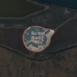
Burdell Island is a former island in the Petaluma River, upstream of San Pablo Bay. While it was previously surrounded by water and swampland, it is now surrounded mostly by dry land. It is part of Marin County, California. Its coordinates are 38°09′22″N122°33′17″W, and the United States Geological Survey gave its elevation as 52 ft (16 m) in 1981. It appears in a 1954 USGS map of the region.

Deer Island is a former island in Marin County, California, close to the Novato Creek, upstream of San Pablo Bay. It is now the location of Deer Island Preserve. It used to be inhabited by Antonio DeBorba, who diked the nearby wetlands to avoid having to use a boat to get home. The building is still there on the Northeastern part of the island. Deer Island's coordinates are 38°05′52″N122°32′13″W, and the United States Geological Survey measured its elevation as 167 ft (51 m) in 1981. It appears in a 1954 USGS map of the region.

Neils Island is a former island in Sonoma County, California, close to the Petaluma River, upstream of San Pablo Bay. Its coordinates are 38°11′27″N122°34′41″W, and the United States Geological Survey measured its elevation as 82 ft (25 m) in 1981. It appears in a 1954 USGS map of the region.

Silva Island is an island in San Francisco Bay, formerly completely separated from the mainland but now mostly connected. It is in Marin County, California. Its coordinates are 37°53′15″N122°30′54″W, and the United States Geological Survey gave its elevation as 79 ft (24 m) in 1981.
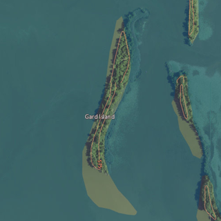
Gard Island is an island in Maumee Bay, in Monroe County, Michigan. Its coordinates are 41°44′55″N83°26′37″W, and the United States Geological Survey gave its elevation as 568 ft (173 m) in 1980. It was labeled "Guard Island", along with Indian Island and Squaw Island, on a 1900 USGS map of the area. A 1938 map showed it alongside Indian Island, Odeen Island, and Woodtick Island.
References
- ↑ "Brant Island". Geographic Names Information System . United States Geological Survey, United States Department of the Interior . Retrieved March 16, 2014.
Coordinates: 41°37′30″N70°49′04″W / 41.62500°N 70.81778°W
| | This Plymouth County, Massachusetts geography–related article is a stub. You can help Wikipedia by expanding it. |