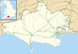
Poole Harbour is a large natural harbour in Dorset, southern England, with the town of Poole on its shores. The harbour is a drowned valley (ria) formed at the end of the last ice age and is the estuary of several rivers, the largest being the Frome. The harbour has a long history of human settlement stretching to pre-Roman times. The harbour is extremely shallow, with one main dredged channel through the harbour, from the mouth to Holes Bay.

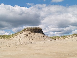
In oceanography, geomorphology, and earth sciences, a shoal is a natural submerged ridge, bank, or bar that consists of, or is covered by, sand or other unconsolidated material, and rises from the bed of a body of water to near the surface. Often it refers to those submerged ridges, banks, or bars that rise near enough to the surface of a body of water as to constitute a danger to navigation. Shoals are also known as sandbanks, sandbars, or gravelbars. Two or more shoals that are either separated by shared troughs or interconnected by past or present sedimentary and hydrographic processes are referred to as a shoal complex.

A spit or sandspit is a deposition bar or beach landform off coasts or lake shores. It develops in places where re-entrance occurs, such as at a cove's headlands, by the process of longshore drift by longshore currents. The drift occurs due to waves meeting the beach at an oblique angle, moving sediment down the beach in a zigzag pattern. This is complemented by longshore currents, which further transport sediment through the water alongside the beach. These currents are caused by the same waves that cause the drift.

Barnegat Bay is a small brackish arm of the Atlantic Ocean, approximately 42 miles (67.2 km) long, along the coast of Ocean County, New Jersey in the United States. It is separated from the Atlantic by the long Barnegat Peninsula, as well as by the north end of Long Beach Island, popular segments of the Jersey Shore. The bay is fed by several small rivers, including the Toms River and Metedeconk River, which empty into the bay through small estuaries along its inner shore. The communities of Toms River, Silverton, and Forked River sit along the river estuaries on the bay.

Hammocks Beach State Park is a North Carolina state park in Onslow County, North Carolina in the United States. Located near Swansboro, along the Southern Outer Banks, or Crystal Coast, the state park covers 1,611 acres (6.52 km2) and consists mainly of Bear Island. The park also owns three smaller islands, Dudley, Huggins and Jones, located in the nearby mouth of the White Oak River. After a recently completed deal, 319 acres (1.29 km2) acres on the mainland were added to the park.
Plum Island is a barrier island located off the northeast coast of Massachusetts, north of Cape Ann, in the United States. It is approximately 11 miles (18 km) in length. The island is named for the wild beach plum shrubs that grow on its dunes. It is located in parts of four municipalities in Essex County. From north to south they are the city of Newburyport, and the towns of Newbury, Rowley, and Ipswich.

Saco Bay is a small curved embayment of the Gulf of Maine on the Atlantic coast of Maine in the United States. The name derives "from a map of the coastline made in 1525 by the Spanish explorer Esteban Gómez. He named the bay Bahio de Saco ."

Humboldt Bay is a natural bay and a multi-basin, bar-built coastal lagoon located on the rugged North Coast of California, entirely within Humboldt County. It is the largest protected body of water on the West Coast between San Francisco Bay and Puget Sound, the second largest enclosed bay in California, and the largest port between San Francisco and Coos Bay, Oregon. The largest city adjoining the bay is Eureka, the regional center and county seat of Humboldt County, followed by the town of Arcata. These primary cities together with adjoining unincorporated communities and several small towns comprise a Humboldt Bay Area total population of nearly 80,000 people, which accounts for nearly 60% of the population of Humboldt County. In addition to being home to more than 100 plant species, 300 invertebrate species, 100 fish species, and 200 bird species, the bay and its complex system of marshes and grasses support hundreds of thousands of migrating and local shore birds. Commercially, this second largest estuary in California houses the largest oyster production operations on the West Coast, producing more than half of all oysters farmed in California.

Assateague Island National Seashore is a unit of the National Park Service system of the U.S. Department of the Interior. Located on the East Coast along the Atlantic Ocean in Maryland and Virginia, Assateague Island is the largest natural barrier island ecosystem in the Middle Atlantic states region that remains predominantly unaffected by human development. Located within a three-hour drive to the east and south of the Richmond, Washington, Baltimore, Wilmington, Philadelphia major metropolitan areas plus north of the several clustered smaller cities around Hampton Roads harbor of Virginia with Newport News, Hampton, Norfolk, Portsmouth, Chesapeake and Virginia Beach. The National Seashore offers a setting in which to experience a dynamic barrier island and to pursue a multitude of recreational opportunities. The stated mission of the park is to preserve and protect “unique coastal resources and the natural ecosystem conditions and processes upon which they depend, provide high-quality resource-based recreational opportunities compatible with resource protection and educate the public as to the values and significance of the area”.

The North River is a river, approximately 12 miles (19 km) long, in eastern Massachusetts, the United States. It is primarily a tidal river, formed by the confluence of the Indian Head River and Herring Brook. The North River forms the boundary between the towns of Norwell, Pembroke, Massachusetts, Hanover, Massachusetts and downstream, the boundary between Scituate and Marshfield. The river flows into Massachusetts Bay at New Inlet, where it also converges with the mouth of the South River.

Sandy Point State Reservation is a coastal Massachusetts state park located in the town of Ipswich at the southern tip of Plum Island. The reservation is managed by the Department of Conservation and Recreation and is an important nesting area for the piping plover and the least tern. Access to the reservation is through the adjoining Parker River National Wildlife Refuge.

Bogue Banks form a 21-mile (34 km) barrier island off the mainland of North Carolina in Carteret County. The island, separated from the mainland by Bogue Sound, runs east to west, with the ocean beaches facing due south. Bogue Banks is the only island on the Carteret County shore that has been developed with housing: numerous communities are located on the island and can be accessed by one of two bridges across Bogue Sound, either from Morehead City to Atlantic Beach, which is the more heavily traveled bridge, or from Cape Carteret to Emerald Isle. The communities of Bogue Banks are the most prominent of the Crystal Coast. NC 58 traverses a majority of the island's length. There are several hotels that dot the island, but most of the land contains private houses, some of which are rented out during the summer, or maritime forest. Stores and other commercial properties are limited to the five main communities.

Popponesset Bay System is a group of bays located at the towns of Mashpee and Barnstable (east), on Cape Cod, Massachusetts with a southern shore bounded by water from Nantucket Sound.
Humarock is part of Scituate, Massachusetts, United States 42°08′10″N70°41′26″W. Humarock is a picturesque seaside village surrounded by water and situated on Cape Cod Bay midway between Boston and Plymouth. It was separated from the rest of the town in the Portland Gale of 1898 in which the mouth of the North River shifted. Humarock is now accessible from Scituate only by boat or from the Town of Marshfield by bridge.

The Barker Inlet is a tidal inlet of the Gulf St Vincent in Adelaide, South Australia, named after Captain Collet Barker who first sighted it in 1831. It contains one of the southernmost mangrove forests in the world, a dolphin sanctuary, seagrass meadows and is an important fish and shellfish breeding ground. The inlet separates Torrens Island and Garden Island from the mainland to the East and is characterized by a network of tidal creeks, artificially deepened channels, and wide mudflats. The extensive belt of mangroves are bordered by samphire saltmarsh flats and low-lying sand dunes, there are two boardwalks, and ships graveyards in Broad Creek, Angas Inlet and the North Arm.

Wassaw Island is one of the Sea Islands. It is located on the Atlantic Ocean off the coast of the U.S. state of Georgia and is within the borders of Chatham County of that state. The island and its surrounding marshlands are part of the Wassaw National Wildlife Refuge, which has a total area of 10,053 acres (40.68 km2) of marsh, mudflats, and tidal creeks, including approximately 7 miles (11 km) of undeveloped beaches. The land mass is 76 percent salt marshes and 24 percent beaches, dunes, and maritime forest. The refuge is a part of the Savannah Coastal Refuges Complex.
Chepiwanoxet is a neighborhood in Warwick, Rhode Island, with an island peninsula in Greenwich Bay, an arm of Narragansett Bay. The neighborhood straddles the Amtrak railroad lines, which lies just east of and parallel to the Post Road. Its boundaries are Neptune Street to the North, Alger Avenue to the South, Post Road to the West, and Greenwich Bay to the East. Chepiwanoxet Way, an underpass beneath the Amtrak lines, now serves as the only street access in and out of the neighborhood.
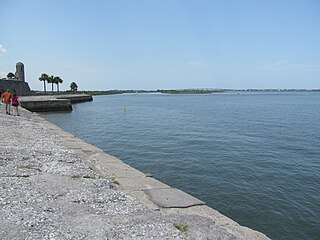
Matanzas Bay is a saltwater bay in St. Johns County, Florida; the entrance to the bay from the South Atlantic is via St. Augustine inlet. Bodies of water that connect to the bay in addition to the South Atlantic are clockwise from the inlet:

Baldoyle Bay is a sea inlet on the east coast of Fingal in Ireland, in the historic County Dublin. It is situated between Portmarnock and Baldoyle. The bay is an important natural feature with protected status, which once held a Viking longphort.
