Barnstable County is a county located in the U.S. state of Massachusetts. At the 2020 census, the population was 228,996. Its shire town is Barnstable. The county consists of Cape Cod and associated islands.
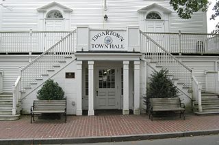
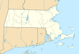
Dukes County is a county located in the U.S. state of Massachusetts. As of the 2020 census, the population was 20,600, making it the second-least populous county in Massachusetts. Its county seat is Edgartown.
Gosnold is a town that encompasses the Elizabeth Islands in Dukes County, Massachusetts, United States. At the 2020 census, the town population was 70, making it the least populous town in Massachusetts. Most of the residents live in the village of Cuttyhunk, while most of the land in the town is owned by the Forbes family.

Bartholomew Gosnold was an English barrister, explorer and privateer who was instrumental in founding the Virginia Company in London and Jamestown in colonial America. He led the first recorded European expedition to Cape Cod. He is considered by Preservation Virginia to be the "prime mover of the colonization of Virginia".

Penikese Island is a 75-acre (0.117 sq mi) island off the coast of Massachusetts, United States, in Buzzards Bay. It is one of the Elizabeth Islands, which make up the town of Gosnold, Massachusetts. Penikese is located near the west end of the Elizabeth island chain.

Naushon Island is the largest of the Elizabeth Islands in southeastern Massachusetts. It is part of the town of Gosnold, Massachusetts, and is owned by the Forbes family. As of the 2000 census, the island had a permanent population of 30 people.

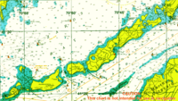
The Elizabeth Islands are a chain of small islands extending southwest from the southern coast of Cape Cod, Massachusetts in the United States. They are located at the outer edge of Buzzards Bay, north of Martha's Vineyard, from which they are separated by Vineyard Sound, and constitute the town of Gosnold in Dukes County, Massachusetts.

Cuttyhunk Island is the outermost of the Elizabeth Islands in Massachusetts. A small outpost for the harvesting of sassafras was occupied for a few weeks in 1602, arguably making it the first English settlement in New England. Cuttyhunk is located between Buzzards Bay to the north and Vineyard Sound to the south. Penikese Island and Nashawena Island are located to the north and east respectively.

Buzzards Bay is a bay of the Atlantic Ocean adjacent to the U.S. state of Massachusetts. It is approximately 28 miles long by 8 miles wide. It is a popular destination for fishing, boating, and tourism. Since 1914, Buzzards Bay has been connected to Cape Cod Bay by the Cape Cod Canal. In 1988, under the Clean Water Act, the Environmental Protection Agency and the Commonwealth of Massachusetts designated Buzzards Bay to the National Estuary Program, as "an estuary of national significance" that is threatened by pollution, land development, or overuse.
John Brereton was a gentleman adventurer and chronicler of the 1602 voyage to the New World led by Bartholomew Gosnold.

Nashawena Island is the second largest of the Elizabeth Islands of Dukes County, Massachusetts, United States. It lies between Cuttyhunk Island to the west and Pasque Island to the east. The island has a land area of 7.076 square kilometres and an official permanent population of 2 persons as of the 2000 U.S. Census. The island is part of the town of Gosnold, Massachusetts. Nashawena is an Indian word meaning "middle island". Rock Island and Baret Island are two small islands located north of Nashawena.
Canapitsit Channel is a channel that runs from Cuttyhunk Harbor to the Vineyard Sound and separates Nashawena Island from Cuttyhunk Island, two of the Elizabeth Islands off Cape Cod, Massachusetts. It is one of four straits allowing maritime passage between Buzzards Bay and the Vineyard Sound. The others are Quick's Hole, Robinson's Hole and Woods Hole. Canapitsit is an Indian word meaning "current passage".

The Tarpaulin Cove Light is a historic lighthouse on Naushon Island, one of the Elizabeth Islands of southern Massachusetts. It is located in the town of Gosnold, Massachusetts. Built on the site of a light station first established privately in the 18th century, the current tower dates from 1891. A keeper's house built at the same time has not survived. The light is 78 feet (24 m) above Mean High Water, and its white light is visible for 9 nautical miles.
Captain Bartholomew Gilbert was an English mariner who in 1602 served as co-captain on the first recorded European expedition to Cape Cod. His decisions resulted in that expedition's failure to establish a colony there.

Elizabeth Islands Military Reservation was a World War II coastal defense site located on Cuttyhunk Island and Nashawena Island in the town of Gosnold, Massachusetts.
Gull Island is a small island located just off the southeast coast of Penikese Island. It is part of the Elizabeth Islands and is entirely part of the town of Gosnold in Dukes County, Massachusetts. At one point it contained the Gull Island Bomb Area, a United States Navy bombing range. Currently, it is uninhabited.
Cuttyhunk Harbor is a bay in Dukes County, Massachusetts. It is located between Copicut Neck on Cuttyhunk Island and Nashawena Island 0.5 miles (0.80 km) northeast of Cuttyhunk in the Town of Gosnold. Cuttyhunk Harbor is connected to Vineyard Sound by Canapitsit Channel. Cuttyhunk is an Indian word meaning "cleared land" or "plantation".
Rock Island is one of the Elizabeth Islands in Dukes County, Massachusetts, United States. It is located in Buzzards Bay off the north shore of Nashawena Island, 2.3 miles (3.7 km) east-northeast of Cuttyhunk in the Town of Gosnold.
Saddleback Hill is a mountain in Dukes County, Massachusetts. It is located on Nashawena Island 2.2 miles (3.5 km) east-northeast of Cuttyhunk in the Town of Gosnold. Middle Pond is located east of Saddleback Hill.
Gabriel Archer was an early explorer who became a settler at Jamestown. He explored Cape Cod with Bartholomew Gosnold before going in the first wave of settlers to Jamestown in 1607. At Jamestown, he clashed with John Smith repeatedly before eventually dying in the winter of 1609-1610, also known as the Starving Time. The Jamestown Rediscovery Project, among other scholars, considers the possibility that Gabriel Archer may have been a Catholic, based on how he was buried.