
The Ashburnham Center Historic District is a historic district encompassing the core of the village center of Ashburnham, Massachusetts in the United States. It is a well-preserved industrial village that experienced its most significant period of growth in the mid-19th century. The district was added to the National Register of Historic Places in 1999.

The West Newton Village Center Historic District encompasses the heart of the village of West Newton, in the city of Newton, Massachusetts in the United States. It extends along Washington Street between Lucas Court in the west and Davis Court in the east, and includes a few properties on immediately adjacent side streets, including Watertown Street and Waltham Street. The village is the second-largest of Newton's commercial centers and is the best-preserved of its late 19th and early 20th century village centers. The district was listed on the National Register of Historic Places in 1990.

The Old Douglas Center Historic District encompasses the historic heart of Douglas, Massachusetts. The historic district radiates away from the town common, and is bounded by farmlands and more recent 20th-century development. There are 50 contributing resources in the 192-acre (78 ha) district. Most of the structures are residential houses in Federal and Greek Revival styles. There are a number of institutional buildings, including the 1834 Greek Revival First Congregational Church, the Craftsman-style Douglas Pastime Club building at 22 Church Street, and the c. 1770s Dudley Tavern. The town common and the adjacent Center Cemetery, laid out when the town was incorporated in 1746, are at the center of the district.

The Barre Common District is a historic district encompassing the town common of Barre, Massachusetts, and immediately adjacent historic buildings. It is bounded roughly by South, Exchange, Main, Pleasant, Broad, School and Grove Streets. The Barre common was laid out in 1792, and has been a focus of the town's civic life ever since, and is flanked by a number of high-quality Greek Revival buildings, as well as those in other styles. The district was listed on the National Register of Historic Places in 1976.

The Gardner Uptown Historic District is a historic district encompassing the former civic heart of Gardner, Massachusetts. The 65-acre (26 ha) area includes the old town common, an early cemetery, and a modest number of non-residential buildings among a larger number of houses. The area was the center of civic life from the incorporation of Gardner in 1785 until municipal functions were moved to West Gardner beginning in the late 1920s. The district was listed on the National Register of Historic Places in 1999.

Phillipston Center Historic District encompasses the historic village center of Phillipston, Massachusetts. The town was first settled in 1751 on land grants made in the 1730s, and was incorporated as a separate town in the 1770s. The surviving village center not far from the location of the first settlement, eventually came to include a tavern. After incorporation, the center developed around what is now the junction of the Baldwinville, Petersham, and Templeton Roads, although this took time, possibly because of difficulties associated with the American Revolutionary War. As a result, the district has relatively few properties that date to the 18th century. All of these are modest vernacular residential structures. The town grew only modestly until 1830, after which time its population declined, not reaching the same level until 1980, 150 years later. As a result of the lack of growth, most of the properties in the district are Federal and Greek Revival in character. Many of the institutional buildings in the center date to the late 19th and early 20th centuries. The district was added to the National Register of Historic Places in 1999.

The Harvard Center Historic District is a historic district encompassing the traditional village center of Harvard, Massachusetts, USA. The district is centered on the town common, a triangular grassy space bounded by Elm Street, Still River Road, and Ayer Road. The common is ringed by residences, civic and religious buildings, and a small commercial area. The common was laid out when the town was founded in 1732, and has grown, mainly in periods of growth at the late 18th and late 19th/early 20th centuries. Most of the village's buildings post-date 1831. The district was added to the National Register of Historic Places in 1997.

The Five Corners Historic District is a historic district encompassing the central district of the village of South Williamstown, Massachusetts. It is centered at the junction of Cold Spring, Green River, New Ashford. The junction has been a prominent center in the area since 1760. Prominent buildings in the district include the South Center School, the Store at Five Corners, and the Second Congregational Church. The district was listed on the National Register of Historic Places in 1993.

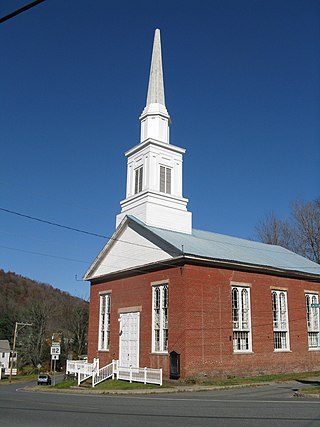
The Bernardston Congregational Unitarian Church is a historic church building at 49 Church Street in Bernardston, Massachusetts. The church is notable for the history of construction, movement, and reconstruction, since it was first erected in 1739, just two years after Bernardston was settled. It was added to the National Register of Historic Places in 1993. Its congregation is affiliated with the Unitarian Universalist Association which was established in 1820.
The Colrain Center Historic District encompasses the historic center of Colrain, Massachusetts, a rural hill town in north-western Franklin County. The 30-acre (12 ha) district was listed on the National Register of Historic Places in 2006.

The Belchertown Center Historic District is a historic district which encompasses the historic village center of Belchertown, Massachusetts. Centered on Belchertown's 1,200-foot (370 m) common, the district includes 55 contributing properties along South Main Street, Maple Street, and a few adjacent streets. It was listed on the National Register of Historic Places in 1982.

The East Village Historic District is a historic district encompassing the center of the East Village of Amherst, Massachusetts, United States. It includes properties on Main Street, North East Street, and South East Street. The village was one of Amherst's principal civic and commercial centers until the arrival of the railroad in Amherst Center in 1853, and remained a primarily residential area thereafter. The district was listed on the National Register of Historic Places in 1986.
The Ware Center Historic District encompasses the historic early center of Ware, Massachusetts. Centered at the junction of Massachusetts Route 9 with Greenwich Plains Road, it is a linear district extending about 0.5 miles (0.80 km) along Route 9 in either direction. Most of the structures in the district were built between 1760 and 1860, although there are some 20th century intrusions. The area was the center of town civic and commercial activity until the 1820s, when villages serving industry became more important. The district was listed on the National Register of Historic Places in 1986.

The Amherst Village Historic District encompasses the historic village center of Amherst, New Hampshire. Centered on the town's common, which was established about 1755, Amherst Village is one of the best examples of a late-18th to early-19th century New England village center. It is roughly bounded on the north by Foundry Street and on the south by Amherst Street, although it extends along some roads beyond both. The western boundary is roughly Davis Lane, the eastern is Mack Hill Road, Old Manchester Road, and Court House Road. The district includes the Congregational Church, built c. 1771-74, and is predominantly residential, with a large number of Georgian, Federal, and Greek Revival houses. Other notable non-residential buildings include the Farmer's Bank, a Federal-style brick building built in 1806, and the Amherst Brick School, a brick Greek Revival structure that has served as the School Administrative Unit 39 offices since 1997.

Stephen Carpenter Earle was an architect who designed a number of buildings in Massachusetts and Connecticut that were built in the late 19th century, with many in Worcester, Massachusetts. He trained in the office of Calvert Vaux in New York City. He worked for a time in partnership with James E. Fuller, under the firm "Earle & Fuller". In 1891, he formed a partnership with Vermont architect Clellan W. Fisher under the name "Earle & Fisher".

The East Leverett Historic District of Leverett, Massachusetts, encompasses the historic mill village of East Leverett. Centered on the intersection of Cushman Road and Shutesbury Road in the southeastern portion of the rural town, it includes predominantly residential buildings that were built during the height of the area's industrial activity in the first four decades of the 19th century. The architecture is mainly Federal and Greek Revival in style. The district was listed on the National Register of Historic Places in 2014.

The Oxford Main Street Historic District is a national historic district encompassing the historic center of Oxford, Massachusetts. The 95-acre (38 ha) district extends along Main Street from Huguenot Street in the south to Front Street in the north. Its oldest buildings are residential houses built in the late 19th century, while most of the properties were built in the 19th century, with Greek Revival architecture predominating. The oldest commercial building, the John Wetherell Store, was built c. 1817, and now houses offices. The district includes four churches, including the 1793 Universalist church and 1829 First Congregational Church, and a number of municipal buildings, including the town hall, two schools, and the 1903 Classical Revival Charles Larned Memorial Library.

The Watertown Center Historic District encompasses the historic village center of Watertown, Connecticut. It exhibits architectural and historic changes from the early 1700s into the 20th century. It is roughly bounded by Main, Warren, North, Woodbury, Woodruff, and Academy Hill Roads, and was listed on the National Register of Historic Places in 2001.

The Middlebury Center Historic District encompasses the historic civic and religious center of Middlebury, Connecticut. Centered at the junction of North and South Streets with Whittemore Road, the district includes churches, schools and municipal buildings, many from the late 19th or early 20th centuries, as well as a diversity of residential architecture. The district includes all the residences along the entire length of North Street, which leads up to the town green. The district was listed on the National Register of Historic Places in 1985.
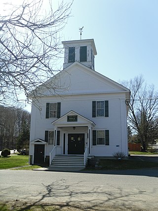
The Gill Center Historic District encompasses the historic 19th-century village center of Gill, Massachusetts. The district is focused on Main Road near its junction with River Road, in the central northern part of the town, and has served as the community's center since its incorporation in 1793. The district was listed on the National Register of Historic Places in 1999; it features a variety of mainly Greek Revival and later Victorian architecture, as well as some 20th-century Colonial Revival buildings.


