Oakhurst, Texas

Last updated

Oakhurst, Texas
Oakhurst Texas Post Office 2023.jpg
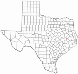
TXMap-doton-Oakhurst.PNG
Location of Oakhurst, Texas
Coordinates: 30°44′26″N95°18′38″W / 30.74056°N 95.31056°W / 30.74056; -95.31056
Country United States
State Texas
County San Jacinto
Area
  Total1.6 sq mi (4.1 km2)
  Land1.6 sq mi (4.1 km2)
  Water0.0 sq mi (0.0 km2)
Elevation
390 ft (119 m)
Population
 (2010)
  Total233
  Density150/sq mi (57/km2)
Time zone UTC-6 (Central (CST))
  Summer (DST) UTC-5 (CDT)
ZIP code
77359
Area code 936
FIPS code 48-52992 [1]
GNIS feature ID1382413 [2]

Oakhurst is a census-designated place and unincorporated community in San Jacinto County, Texas, United States. The population was 233 at the 2010 census. Prior to the 2010 census Oakhurst and Cape Royale CDPs were part of Oakhurst city, which has been disincorporated. [3]

Contents

Geography

Oakhurst is located at 30°44′26″N95°18′38″W / 30.74056°N 95.31056°W / 30.74056; -95.31056 (30.740538, -95.310563). [4]

According to the United States Census Bureau, the city had a total area of 1.6 square miles (4.1 km2), all of it land.

Demographics

As of the census [1] of 2000, there were 230 people, 85 households, and 66 families residing in the city. The population density was 146.5 inhabitants per square mile (56.6/km2). There were 115 housing units at an average density of 73.3 per square mile (28.3/km2). The racial makeup of the city was 84.78% White, 14.78% African American, and 0.43% from two or more races. Hispanic or Latino of any race were 3.04% of the population.

There were 85 households, out of which 32.9% had children under the age of 18 living with them, 64.7% were married couples living together, 10.6% had a female householder with no husband present, and 21.2% were non-families. 17.6% of all households were made up of individuals, and 7.1% had someone living alone who was 65 years of age or older. The average household size was 2.71 and the average family size was 3.06.

In the city the population was spread out, with 27.8% under the age of 18, 8.7% from 18 to 24, 19.1% from 25 to 44, 31.3% from 45 to 64, and 13.0% who were 65 years of age or older. The median age was 39 years. For every 100 females, there were 103.5 males. For every 100 females age 18 and over, there were 90.8 males.

The median income for a household in the city was $39,167, and the median income for a family was $40,909. Males had a median income of $31,875 versus $35,417 for females. The per capita income for the city was $15,987. About 5.0% of families and 17.8% of the population were below the poverty line, including 26.8% of those under the age of eighteen and 30.8% of those 65 or over.

Notable people

Education

Oakhurst is served by the Coldspring-Oakhurst Consolidated Independent School District.

Related Research Articles

<span class="mw-page-title-main">San Jacinto County, Texas</span> County in Texas, United States

San Jacinto County is a county in the U.S. state of Texas. As of the 2020 census, its population was 27,402. Its county seat is Coldspring. The county's name comes from the Battle of San Jacinto which secured Texas' independence from Mexico and established a republic in 1836.

Salamatof is a census-designated place (CDP) in Kenai Peninsula Borough, Alaska, United States. The population was 1,078 at the 2020 census, up from 980 in 2010. Salamatof is the location for the former Wildwood Air Force Station, which operated from 1965 to 1972. Today, it is the Wildwood Correctional Complex.

<span class="mw-page-title-main">Eagle, Idaho</span> City in Idaho, United States

Eagle is a city in the western United States in Ada County, Idaho, ten miles (16 km) northwest of downtown Boise. The population was 30,346 at the time of the 2020 census.

<span class="mw-page-title-main">Kootenai, Idaho</span> City in Idaho, United States

Kootenai is a city in Bonner County, Idaho. The population was 678 at the 2010 census.

<span class="mw-page-title-main">Lakeside, Iowa</span> City in Iowa, United States

Lakeside is a city in Buena Vista County, Iowa, United States. The population was 700 at the time of the 2020 census. It is the most densely populated city in Iowa.

<span class="mw-page-title-main">Lewis, Iowa</span> City in Iowa, United States

Lewis is a city in Cass County, Iowa, United States, along the East Nishnabotna River. The population was 357 at the time of the 2020 census.

<span class="mw-page-title-main">Emerson, Iowa</span> City in Iowa, United States

Emerson is a city in Mills County, Iowa, United States. The population was 403 at the time of the 2020 census.

<span class="mw-page-title-main">Windsor, Maine</span> Town in the state of Maine, United States

Windsor is a town in Kennebec County, Maine, United States. The population was 2,632 at the 2020 census. Windsor is included in the Augusta, Maine micropolitan New England City and Town Area.

<span class="mw-page-title-main">Trail, Minnesota</span> City in Minnesota, United States

Trail is a city in Polk County, Minnesota, United States. It is part of the Grand Forks, ND-MN Metropolitan Statistical Area. The population was 40 at the 2020 census.

<span class="mw-page-title-main">Wynot, Nebraska</span> Village in Nebraska, United States

Wynot is a village in Cedar County, Nebraska, United States. The population was 217 at the 2020 census.

<span class="mw-page-title-main">Oakhurst, New Jersey</span> Place in Monmouth County, New Jersey, United States

Oakhurst is an unincorporated community and census-designated place (CDP) within Ocean Township, in Monmouth County, in the U.S. state of New Jersey. As of the 2010 United States Census, the CDP's population was 3,995.

<span class="mw-page-title-main">Pisek, North Dakota</span> City in North Dakota, United States

Pisek is a city in Walsh County, North Dakota, United States. The population was 89 at the 2020 census.

<span class="mw-page-title-main">Drexel, Ohio</span> CDP in Ohio, United States

Drexel is a census-designated place (CDP) in Jefferson Township, Montgomery County, Ohio, United States. The population was 1,693 at the 2020 census. Informally, the Drexel designation also applies to the neighboring portion of Trotwood.

<span class="mw-page-title-main">Martinsburg, Pennsylvania</span> Borough in Pennsylvania, United States

Martinsburg is a borough in the Morrisons Cove section of Blair County, Pennsylvania, United States. The population was 1,874 at the 2020 census. It is part of the Altoona, PA Metropolitan Statistical Area.

<span class="mw-page-title-main">Dale, Pennsylvania</span> Borough in Pennsylvania, United States

Dale is a borough in Cambria County, Pennsylvania, United States. It is part of the Johnstown, Pennsylvania Metropolitan Statistical Area. The population was 1,234 at the 2010 census, down from 1,503 at the 2000 census.

<span class="mw-page-title-main">Adamsburg, Pennsylvania</span> Borough in Pennsylvania, United States

Adamsburg is a borough that is located in Westmoreland County, Pennsylvania, United States. The population was 144 at the time of the 2020 federal census.

<span class="mw-page-title-main">Chelsea, South Dakota</span> Town in South Dakota, United States

Chelsea is a town in Faulk County, South Dakota, United States. The population was 19 at the 2020 census.

<span class="mw-page-title-main">Leeds, Wisconsin</span> Town in Wisconsin, United States

Leeds is a town in Columbia County, Wisconsin, United States. The population was 813 at the 2000 census. The unincorporated communities of Keyeser, Leeds, Leeds Center, and North Leeds are located in the town. The town took its name from the city of Leeds, England.

<span class="mw-page-title-main">Oakhurst, Oklahoma</span> Census-designated place in Oklahoma, United States

Oakhurst is an unincorporated community and census-designated place (CDP) in Creek and Tulsa counties in the U.S. state of Oklahoma. The population was 2,185 at the 2010 census, a loss of 20 percent from 2,731 at the 2000 census.

<span class="mw-page-title-main">Rochester, Wisconsin</span> Village in Wisconsin

Rochester is a village in Racine County, Wisconsin, United States. The population was 3,785 at the 2020 census. The village is located within the former Town of Rochester. On November 4, 2008, the village of Rochester voted to consolidate with the Town of Rochester.

References

  1. 1 2 "U.S. Census website". United States Census Bureau . Retrieved January 31, 2008.
  2. "US Board on Geographic Names". United States Geological Survey. October 25, 2007. Retrieved January 31, 2008.
  3. "Population and Housing Unit Counts, 2010 Census of Population and Housing" (PDF). Texas: 2010.
  4. "US Gazetteer files: 2010, 2000, and 1990". United States Census Bureau. February 12, 2011. Retrieved April 23, 2011.