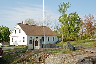
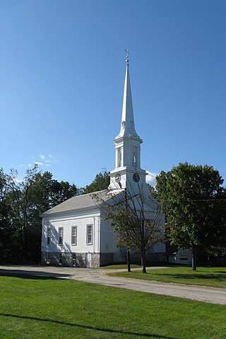
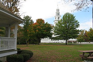
The Lyndeborough Center Historic District, located in the town of Lyndeborough, New Hampshire, United States, consists of three structures: the Town Pound, Town Hall, and Congregational Church. The district was placed on the National Register of Historic Places in 1984. In 2010, by town meeting vote, this district became part of a larger, officially zoned local historic district.

The Old Douglas Center Historic District encompasses the historic heart of Douglas, Massachusetts. The historic district radiates away from the town common, and is bounded by farmlands and more recent 20th-century development. There are 50 contributing resources in the 192-acre (78 ha) district. Most of the structures are residential houses in Federal and Greek Revival styles. There are a number of institutional buildings, including the 1834 Greek Revival First Congregational Church, the Craftsman-style Douglas Pastime Club building at 22 Church Street, and the c. 1770s Dudley Tavern. The town common and the adjacent Center Cemetery, laid out when the town was incorporated in 1746, are at the center of the district.

The Lunenburg Historic District is a historic district encompassing the historic center of Lunenburg, Massachusetts. The district is centered on a stretch of Main Street which connects two triangular intersections. It includes many of the town's oldest buildings, including the c. 1724 Cushing House, and the c. 1730 Stillman Stone House. Three of the town's most significant institutional buildings were built before 1850: the town hall, the Congregational church, and the Methodist church. The district was added to the National Register of Historic Places in 1988.

The Gardner Uptown Historic District is a historic district encompassing the former civic heart of Gardner, Massachusetts. The 65-acre (26 ha) area includes the old town common, an early cemetery, and a modest number of non-residential buildings among a larger number of houses. The area was the center of civic life from the incorporation of Gardner in 1785 until municipal functions were moved to West Gardner beginning in the late 1920s. The district was listed on the National Register of Historic Places in 1999.

The South Britain Historic District encompasses the core of the unincorporated village of South Britain in Southbury, Connecticut, United States. The village arose in the 18th century as an industrial center serving the surrounding agricultural community, powered by the Pomperaug River, and rivalled the town center of Southbury in importance. The district was listed on the National Register of Historic Places in 1987.
Royalston Common Historic District is a historic district encompassing the historic village center of Royalston, Massachusetts. Centered on a long town common laid out in 1752, it is one of the best surviving examples of an 18th-century town center in the state. The district was listed on the National Register of Historic Places in 1976. The common was named as one of the 1,000 places to visit in Massachusetts by the Great Places in Massachusetts Commission.
The Templeton Common Historic District encompasses the historic town center of Templeton, Massachusetts. Laid out in the 1750s, the area has been the focus of the town's civic and economic affairs since, and includes its finest assortment of 18th and early 19th-century architecture. The district was added to the National Register of Historic Places in 1983. The district was in 2010 named as one of the 1,000 places to visit in Massachusetts by the Great Places in Massachusetts Commission.

Becket Center Historic District is a historic district encompassing the historic early center of Becket, Massachusetts. Centered at the junction of Massachusetts Route 8 and YMCA Road, this area was the town's civic heart and a center of industry until it was eclipsed in importance by North Becket, which was served by the railroad. Most of the architecture in the district is in the Federal and Greek Revival styles popular in the late 18th to mid 19th centuries. The district was added to the National Register of Historic Places in 1982.

The Hamilton Historic District encompasses the early historic center of Hamilton, Massachusetts. It includes properties at 540-700 and 563-641 Bay Road, extending along the road from Orchard Road in the south to Cutler Road in the north. Numerous Greek Revival buildings are located within the district including the First Congregational Church of Hamilton, built in 1843. The district was added to the National Register of Historic Places in 1973.

The Howe Village Historic District is a historic district in Boxford, Massachusetts. It encompasses an area in and around Massachusetts Route 97, just east of Interstate 95 and south of the junction of those two roads, and includes most of the properties on Ipswich Road and a few on adjacent roads. This area was among the first to be settled in what is now Boxford, and consists of a rural cluster of houses built between about 1750 and 1850. The district was listed on the National Register of Historic Places in 1973.
The Topsfield Town Common District encompasses the historic town common and surrounding buildings in Topsfield, Massachusetts. The common, established by 1650, is the traditional civic and religious center of the town, and is surrounded by houses dating from the 17th to 20th centuries, the town hall, library, and Congregational church. It was added to the National Register of Historic Places in 1976.

The Common Historic District is a historic district encompassing the civic and institutional heart of Reading, Massachusetts. The district is centered on the town common, at the intersection of Main and Salem Streets. The common has been communally owned since at least 1737, with the original burying ground to the north. In 1769 the area's first meeting house was built, giving the area a sense of identity separate from portions of Reading that would later be set off as Wakefield and North Reading. Since then the area has become a focal point for religious and civic institutions in the town.

Norwichtown is a historic neighborhood in the city of Norwich, Connecticut. It is generally the area immediately north of the Yantic River between I-395 and Route 169.

The Hollis Village Historic District encompasses the historic village center of Hollis, New Hampshire. The district is centered on Monument Square, which connects Main Street to Depot Street and Broad Street. It covers about 400 acres (160 ha), and extends along all three of those roads for some distance, and includes properties on Silver Lake Road and Ash Street. Most of the buildings in the district are residential or agricultural in use, and date before the turn of the 20th century; the oldest buildings date to the mid-18th century. The "Always Ready Engine House", which occupies a triangular parcel at the western end of Monument Square, was built in 1859, and is the town's oldest municipal building. Its most architecturally sophisticated building is the town hall, built in 1887 to a design by William M. Butterfield of Manchester. The district represents the growth of a mainly agricultural community over a 200-year period. The district was listed on the National Register of Historic Places in 2001.

The Amherst Village Historic District encompasses the historic village center of Amherst, New Hampshire. Centered on the town's common, which was established about 1755, Amherst Village is one of the best examples of a late-18th to early-19th century New England village center. It is roughly bounded on the north by Foundry Street and on the south by Amherst Street, although it extends along some roads beyond both. The western boundary is roughly Davis Lane, the eastern is Mack Hill Road, Old Manchester Road, and Court House Road. The district includes the Congregational Church, built c. 1771-74, and is predominantly residential, with a large number of Georgian, Federal, and Greek Revival houses. Other notable non-residential buildings include the Farmer's Bank, a Federal-style brick building built in 1806, and the Amherst Brick School, a brick Greek Revival structure that has served as the School Administrative Unit 39 offices since 1997.
The Andover Center Historic District encompasses the historic town center of Andover, Connecticut. Centered on the junction of Hebron Road with Center Street and Cider Mill Road, the district includes houses dating to the town's early history, civic buildings including a library and former town hall, and the town's first cemetery. The district was listed on the National Register of Historic Places in 2003.

The East Andover Village Center Historic District encompasses the historic village center of East Andover, New Hampshire, United States. The 2.2-acre (0.89 ha) district includes a cemetery and three buildings: the Andover Congregational Church, the Highland Lake Grange Hall, and the East Andover Schoolhouse. It is located at the corner of New Hampshire Route 11 and Chase Hill Road. The district is unified by the appearance of the three buildings, and their styling, which is predominantly vernacular 19th century.

The Lyme Common Historic District encompasses the original historic center of Lyme, New Hampshire. Established in 1781, it includes sixty historic buildings surrounding the town common and along surrounding roads, and is a well-preserved example of a 19th-century village center. The district was listed on the National Register of Historic Places in 1988.
The New Ipswich Center Village Historic District encompasses the historic center of the rural town of New Ipswich, New Hampshire. The center village is the town's most densely populated area, with a history dating to the town's founding in 1735. The district extends along Turnpike Road between King and Porter Roads, and southward in a roughly triangular shape, the southern point of which is at the junction of Main Street and Willard Road. The village includes a large number of residences, which were mainly agricultural at first, but also include a number of properties built as summer resort houses in the late 19th and early 20th centuries. It also includes most of the town's historic civic buildings, including its historic town hall, and the Barrett House, now a museum property owned by Historic New England. The district was listed on the National Register of Historic Places in 1991.
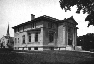
The Winchendon Village Historic District encompasses the 19th-century commercial center of Winchendon, Massachusetts. It extends along Front and School Streets from School Square to Spring Street, and continues north on Central Street as far as Summer Street. This area was developed primarily because of industrialization that took place along Miller's River beginning in the late 18th century and extending into the 1830s, and then expanded further with the arrival of the railroad in the area in the 1840s. This growth caused the area to eclipse the town's colonial town center. The area had risen to sufficient prominence by 1850 that the town hall was built there, which would be followed by other municipal buildings, including the 1913 Beals Memorial Library. The district was listed on the National Register of Historic Places in 1993.


