The Bronx River Parkway is a 19.12-mile (30.77 km) limited-access parkway in downstate New York in the United States. It is named for the nearby Bronx River, which it parallels. The southern terminus of the parkway is at Story Avenue near the Bruckner Expressway in the Bronx neighborhood of Soundview. The northern terminus is at Kensico Circle in North Castle, Westchester County, where the parkway connects to the Taconic State Parkway and via a short connector, New York State Route 22 (NY 22). Within the Bronx, the parkway is maintained by the New York State Department of Transportation and is designated New York State Route 907H (NY 907H), an unsigned reference route. In Westchester County, the parkway is maintained by the Westchester County Department of Public Works and is designated unsigned County Route 9987 (CR 9987).
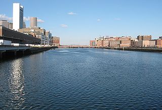
Fort Point Channel is a maritime channel separating South Boston from downtown Boston, Massachusetts, feeding into Boston Harbor. The south part of it has been gradually filled in for use by the South Bay rail yard and several highways. At its south end, the channel once widened into South Bay, from which the Roxbury Canal continued southwest where the Massachusetts Avenue Connector is now. The Boston Tea Party occurred at its northern end. The channel is surrounded by the Fort Point neighborhood, which is also named after the same colonial-era fort.

The Department of Conservation and Recreation (DCR) is a state agency of the Commonwealth of Massachusetts, United States, situated in the Executive Office of Energy and Environmental Affairs. It is best known for its parks and parkways. The DCR's mission is "To protect, promote and enhance our common wealth of natural, cultural and recreational resources for the well-being of all." The agency is the largest landowner in Massachusetts.

Revere Beach Parkway is a historic parkway in the suburbs immediately north of Boston, Massachusetts. It begins at Wellington Circle in Medford, where the road leading to the west is Mystic Valley Parkway, and the north–south road is the Fellsway, designated Route 28. The parkway proceeds east, ending at Eliot Circle, the junction of Revere Beach Boulevard and Winthrop Parkway in Revere. In between, the parkway passes through the cities of Everett and Chelsea. The parkway was built between 1896 and 1904 to provide access from interior communities to Revere Beach. It underwent two major periods of capacity expansion, in the 1930s and again in the 1950s. The parkway is designated as part of Route 16 west of Route 1A, and as part of Route 145 east of that point.

The National Register of Historic Places is a United States federal official list of places and sites considered worthy of preservation. In the state of Massachusetts, there are over 4,300 listings, representing about 5% of all NRHP listings nationwide and the second-most of any U.S. state, behind only New York. Listings appear in all 14 Massachusetts counties.

Broad Street is a major arterial street in Philadelphia, Pennsylvania. The street runs for approximately 13 miles (21 km), beginning at the intersection of Cheltenham Avenue on the border of Cheltenham Township and the West/East Oak Lane neighborhoods of North Philadelphia to the Philadelphia Navy Yard in South Philadelphia. It is Pennsylvania Route 611 along its entire length with the exception of its northernmost part between Old York Road and Pennsylvania Route 309 and the southernmost part south of Interstate 95.

The Dorchesterway was a parkway planned by 19th century landscape designer Frederick Law Olmsted to be a continuation of the Emerald Necklace park network in Boston, Massachusetts. This plan, however, was never implemented.

Morton Street is a street in southern Boston, Massachusetts, United States. It extends from the southeastern end of the Arborway in Jamaica Plain to Washington Street in the Lower Mills Village of Dorchester. Most of the road is a connecting parkway, signed as part of Massachusetts Route 203, that provides access to Boston's Emerald Necklace of parks. That portion of the road was listed on the National Register of Historic Places in 2005.

The Neponset Valley Parkway is a historic parkway in southern Boston and Milton, Massachusetts, United States. It is a connecting parkway in the Greater Boston area's network, providing a connection between the Blue Hills Reservation, Neponset River Reservation, and the Stony Brook Reservation. The parkway was constructed between 1898 and 1929 with design assistance from Charles Eliot and the Olmsted Brothers. It was listed on the National Register of Historic Places in 2005.

The Stony Brook Reservation Parkways are a group of historic parkways in Boston and Dedham, Massachusetts. They provide access to and within the Stony Brook Reservation, a Massachusetts state park. The roadways and the park are administered by the Massachusetts Department of Conservation and Recreation, a successor to the Metropolitan District Commission, which oversaw their construction. The roads consist of the Dedham, Enneking, and Turtle Pond Parkways and West Boundary Road. Two roads within the park, Smithfield Road and Reservation Road, are listed as non-contributing properties. The park roads were built between 1894 and 1956, and were listed on the National Register of Historic Places in 2006.

Fresh Pond Parkway is a historic park and parkway on the western end of Cambridge, Massachusetts. It is part of the Metropolitan Park System of Greater Boston. The parkway was built in 1899 and added to the National Register of Historic Places in 2005.

Nahant Beach Boulevard, also Nahant Causeway and Nahant Road, is a historic road on the isthmus connecting Nahant, Massachusetts to the mainland at Lynn, Massachusetts, United States. The road runs from the Lynn Rotary, its junction with Lynn Shore Drive and the Lynnway, about 1.5 miles (2.4 km) to Wilson Road in Nahant. It passes through Nahant Beach Reservation, a state park offering beach access on the isthmus. The road offers expansive views of the area coastlines and Boston Harbor. Both the park and the roadway are administered by the Massachusetts Department of Conservation and Recreation.

The Fells Connector Parkways are a group of historic parkways in the cities of Malden and Medford, Massachusetts, suburbs north of the city of Boston. The three parkways, The Fellsway, Fellsway West, and Fellsway East serve to provide access from the lower portion of the Mystic River Reservation to the Middlesex Fells Reservation. The latter two parkways continue northward, providing access to the interior of the Fells and providing a further connection to Lynn Fells Parkway. Significant portions of these parkways south of the Fells, which were among the first connecting parkways designed to be part of the Metropolitan Park System of Greater Boston by Charles Eliot, were listed on the National Register of Historic Places in 2003.

The Charles River Reservation Parkways are parkways that run along either side of the Charles River in eastern Massachusetts. The roads are contained within the Charles River Reservation and the Upper Charles River Reservation, and fall within a number of communities in the greater Boston metropolitan area. The Charles River parks extend from the Charles River Dam, where the Charles empties into Boston Harbor, to Riverdale Park in the West Roxbury neighborhood of Boston. Most of the roadways within the parks are listed on the National Register of Historic Places as a unit, although Storrow Drive and Memorial Drive are listed as part of the Charles River Basin Historic District.

The Middlesex Fells Reservation Parkways are the roadways within and bordering on the Middlesex Fells Reservation, a state park in the northern suburbs of Boston, Massachusetts, United States. The park includes portions of the towns of Malden, Medford, Melrose, Stoneham, and Winchester. The roads inside the park and around its perimeter have been listed on the National Register of Historic Places. Other portions of some of the roads are covered by more than one listing in the national register; see Fellsway Connector Parkways and Middlesex Fells Reservoirs Historic District.

Furnace Brook Parkway is a historic parkway in Quincy, Massachusetts. Part of the Metropolitan Park System of Greater Boston, it serves as a connector between the Blue Hills Reservation and Quincy Shore Reservation at Quincy Bay. First conceived in the late nineteenth century, the state parkway is owned and maintained by the Massachusetts Department of Conservation and Recreation (DCR) and travels through land formerly owned by the families of John Adams and John Quincy Adams, passing several historic sites. It ends in the Merrymount neighborhood, where Quincy was first settled by Europeans in 1625 by Captain Richard Wollaston. The road was started in 1904, completed in 1916 and added to the National Register of Historic Places (NRHP) in 2004.

Blue Hills Parkway is a historic parkway that runs in a straight line from a crossing of the Neponset River, at the south border of Boston to the north edge of the Blue Hills Reservation in Milton, Massachusetts. It was built in 1893 to a design by the noted landscape architect, Charles Eliot, who is perhaps best known for the esplanades along the Charles River. The parkway is a connecting road between the Blue Hills Reservation and the Neponset River Reservation, and was listed on the National Register of Historic Places in 2003.

Hammond Pond Parkway is a historic parkway in Chestnut Hill, Massachusetts. The road, built in 1932, extends 2 miles (3.2 km) from Hobart Road in Newton to Horace James Circle in Brookline, where it joins the West Roxbury Parkway. It was designed by Charles Eliot and the Olmsted Brothers to provide a parkway setting that provided access from Brookline, Newton, and the western portions of Boston to the southern parks of the Emerald Necklace. The parkway was listed on the National Register of Historic Places in 2004.

West Roxbury Parkway is a historic parkway running from Washington Street in Boston, Massachusetts, where the Enneking Parkway runs south, to Horace James Circle in Chestnut Hill, where it meets the Hammond Pond Parkway. The parkway serves as a connector between Stony Brook Reservation and Hammond Pond Reservation. West Roxbury Parkway was built between 1919 and 1929 and added to the National Register of Historic Places in 2006. The parkway is distinctive in the roadway system developed by the Metropolitan District Commission beginning around the turn of the 20th century in that it was built in collaboration with the City of Boston, and is maintained by the city.

William J. Day Boulevard, or Day Boulevard, is a coastal parkway in Boston, Massachusetts. Beginning at Morrissey Boulevard and Kosciuszko Circle at the northern extent of the Dorchester section of the city, it travels in a gently curving northeasterly direction 2.6 miles (4.2 km) through South Boston along beaches around the west and north shore of Dorchester Bay. It was named for William J. Day.


