
Martha's Vineyard, often simply called the Vineyard, is an island in the U.S. state of Massachusetts, lying just south of Cape Cod. It is known for being a popular, affluent summer colony, and includes the smaller peninsula Chappaquiddick Island. It is the 58th largest island in the U.S., with a land area of about 96 square miles (250 km2), and the third-largest on the East Coast, after Long Island and Mount Desert Island. Martha's Vineyard constitutes the bulk of Dukes County, Massachusetts, which also includes the Elizabeth Islands and the island of Nomans Land.

Dukes County is a county located in the U.S. state of Massachusetts. As of the 2020 census, the population was 20,600, making it the second-least populous county in Massachusetts. Its county seat is Edgartown.
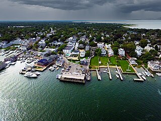
Edgartown is a town on the island of Martha's Vineyard in Dukes County, Massachusetts, United States, for which it is the county seat. The town's population was 5,168 at the 2020 census.

Oak Bluffs is a town located on the island of Martha's Vineyard in Dukes County, Massachusetts, United States. The population was 5,341 at the 2020 United States Census. It is one of the island's principal points of arrival for summer tourists, and is noted for its "gingerbread cottages" and other well-preserved mid- to late-nineteenth-century buildings. The town has been a historically important center of African American culture since the eighteenth century.
Tisbury is a town located on Martha's Vineyard in Dukes County, Massachusetts, United States. The population was 4,815 at the 2020 census.

West Tisbury is a town located on Martha's Vineyard in Dukes County, Massachusetts, United States. The population was 3,555 at the 2020 census. Along with Chilmark and Aquinnah, West Tisbury forms "Up-Island" Martha's Vineyard.

The Polly Hill Arboretum includes 8 ha under cultivation, with an additional 16 ha of native woodland, located on Martha's Vineyard at 809 State Road, West Tisbury, Massachusetts, United States. It has been developed since 1958 by the horticulturist Polly Hill, and was listed on the National Register of Historic Places in 2015.
The Edgartown School is located on Martha's Vineyard, Massachusetts. Current enrollment stands at about 348. The school mascot is the Eagle.

West Chop Light is a lighthouse station located at the entrance of Vineyard Haven Harbor in Tisbury, Massachusetts, on the northern tip of West Chop, a few miles from the village of Vineyard Haven.

The Nantucket Historic District is a National Historic Landmark District that encompasses the entire island of Nantucket, Massachusetts. The original December 13, 1966 listing on the National Register of Historic Places included only the historic downtown core and the village of Siasconset, but was expanded in 1975 to include the entire island, as well as the islands of Tuckernuck and Muskeget. At over 30,000 acres, it is the largest conventional historic National Historic Landmark District by area in the contiguous United States.

Lambert's Cove Beach is a well-known beach in the town of West Tisbury on the island of Martha's Vineyard in Massachusetts, United States. The beach is located off Lambert's Cove Road and is situated in a cove off of Vineyard Sound facing west towards the Elizabeth Islands. It is known chiefly for the beauty of the beach and the setting, which recalls a Caribbean cove.
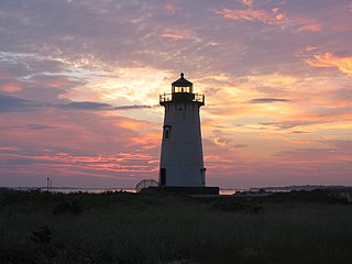
Edgartown Harbor Light is a lighthouse located in Edgartown, Massachusetts, United States, where it marks the entrance to Edgartown Harbor and Katama Bay. It is one of five lighthouses on the island of Martha's Vineyard. The first lighthouse, a two-story wooden structure that also served as the keeper's house, was constructed in 1828. It was demolished, and replaced by the current cast-iron tower, in 1939. Originally located on an artificial island 1/4 miles from shore, the lighthouse is now surrounded by a beach formed, since 1939, by sand accumulating around the stone causeway connecting it to the mainland.

Gay Head Light is a historic lighthouse located on Martha's Vineyard westernmost point off of Lighthouse Road in Aquinnah, Massachusetts.

The William Street Historic District is a historic district in Vineyard Haven, Massachusetts, on the island of Martha's Vineyard. The district includes houses on William Street from Woodlawn Avenue in the north to several houses south of Camp Street. It represents the single best preserved area of mid 19th century houses in Vineyard Haven.

The West Chop Club Historic District is a historic district in Tisbury, Massachusetts, on the island of Martha's Vineyard. The district represents a well-preserved planned summer resort community of the late 19th century. Located in and around Iroquois Avenue, the district encompasses the northernmost portion of West Chop, a peninsula that separates Vineyard Sound and the sheltered waters of Vineyard Haven Harbor, an area that was developed by the West Chop Land Company in the 1880s. The land is now owned by the West Chop Land Trust and managed by the private West Chop Club. The district was listed on the National Register of Historic Places in 2007.
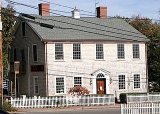
The Ritter House is an historic house on Beach Street in Vineyard Haven, Massachusetts, USA, and is listed on the National Register of Historic Places. The house is one of the few remaining Federal period buildings in Vineyard Haven. It has had a succession of occupants and uses, and as of 2007 served as a retail establishment.

The Andover Village Industrial District encompasses one of the 19th century industrial mill villages of Andover, Massachusetts known locally as "The Village". The growth of this village contributed to the decision in the 19th century to separate the more rural area of North Andover from the town. It is centered on a stretch of the Shawsheen River between North Main Street on the east and Moraine Street on the west. Most of the district's properties lie on Stevens Street, Red Spring Road, Shawsheen Road, and Essex Street, with a few properties also located on adjacent roads.
Satinet is a finely woven fabric with a finish resembling satin, but made partly or wholly from cotton or synthetic fiber. The fibers may be natural or synthetic.

Martha's Vineyard Transit Authority(VTA) is a bus transportation system serving Martha's Vineyard, Massachusetts. In addition to diesel buses, it has 19 electric buses charged at several points. The Edgartown facility has 700 kW solar panels and a 1.5 MWh battery adding to the bus power.

Lansdowne Park is a heritage-listed homestead at Bungonia Road, Goulburn, Goulburn Mulwaree Council, New South Wales, Australia. It was built from 1822 to 1825. It is also known as Lansdowne. It was added to the New South Wales State Heritage Register on 2 April 1999.


