Related Research Articles

Butte County is a county in northern California. In the 2010 census, the population was 220,000. The county seat is Oroville.
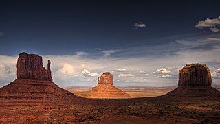
In geomorphology, a butte is an isolated hill with steep, often vertical sides and a small, relatively flat top; buttes are smaller landforms than mesas, plateaus, and tablelands. The word butte comes from a French word meaning knoll ; its use is prevalent in the Western United States, including the southwest where mesa is used for the larger landform. Due to their distinctive shapes, buttes are frequently landmarks in plains and mountainous areas. To differentiate the two landforms, geographers use the rule of thumb that a mesa has a top that is wider than its height, while a butte has a top that is narrower than its height.

Butte Meadows is a census-designated place in Butte County, California, 5 miles off State Route 32 on Humboldt Rd. The area is about 45 minutes or 33 miles (53 km) east of Chico on SR32. Its elevation is listed at 4,340 feet (1,323 m) above sea level: certain to get snow in winter of any year. The area code is Area code 530. The area is just over one mile (1.6 km) from the Tehama County line. The post office that served Butte Meadows moved back and forth across the county line several times from 1878 to 1888. Butte Meadows' population was 40 at the 2010 census.

Butte Creek is tributary to the Sacramento River, joining the river in the vicinity of Colusa, California, United States. About 93 miles (150 km) in length, it runs through much of Butte County, California. It travels through a spectacular mini-Grand Canyon as it reaches the Sacramento Valley floor, where it then flows somewhat south and west of the city of Chico towards the southwestern corner of the county.
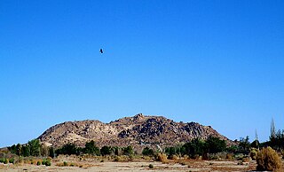
Saddleback Butte State Park is a state park in the Antelope Valley of the western Mojave Desert, in Southern California. It is located east of Lancaster, north of the community of Lake Los Angeles, and south of Edwards in the unincorporated community of Hi Vista.
Centerville is an unincorporated community in Butte County, California along Butte Creek. It was midway between Helltown and Diamondville. The area is about one and three quarters miles, straight-line distance, west of Paradise.

Enterprise is a former settlement in Butte County, California. It was located 5 miles (8.0 km) west-northwest of Forbestown on the South Fork of the Feather River, at an elevation of 902 feet. In 1968, it was inundated by Lake Oroville.

Dayton is an unincorporated town in Butte County, California. It lies south of Chico at an elevation of 141 feet.
Big Bend is an unincorporated community in Butte County, California, United States. It lies at an elevation of 2310 feet. A post office operated in Big Bend from 1883 to 1891.
Helltown is an unincorporated community in Butte County, California. It lies 4 miles (6.4 km) north-northwest of Paradise, at an elevation of 873 feet.
Hurleton is an unincorporated community in Butte County, California. It is located 7.5 miles (12.1 km) north of Bangor. It lies at an elevation of 1598 feet.
Jonesville is an unincorporated community in Butte County, California. It is situated on Jones Creek, 5 miles (8.0 km) east-northeast of Butte Meadows, at an elevation of 5049 feet.
Lomo is an unincorporated community in Butte County, California. It lies 4.5 miles (7.2 km) of Butte Meadows, at an elevation of 3779 feet. A post office operated at Lomo from 1878 to 1881.
Powellton was an unincorporated community in Butte County, California, USA. It lies at an elevation of 3,622 feet. The place is named for R.P. Powell who arrived in 1853. Originally Powell's Ranch, it was renamed when a post office was established in 1872; the office closed in 1906. It was a center of lumber production in its heyday, but nothing remains at the site.
South Fork is a former settlement in Butte County, California, USA. It lay at an elevation of 1375 feet. It still appeared on maps as of 1947, and was inundated by Lake Oroville. South Fork was located 1.25 miles (2 km) east-southeast of Bidwell's Bar on the Feather River.
Sunnyslope is an unincorporated community in Butte County, California, United States.

Butte Valley is an unincorporated community and census-designated place (CDP) named for a former settlement in Butte County, California, United States. It is located 5.5 miles (8.9 km) southeast of Chico. A post office operated at Butte Valley from 1861 to 1871, when it was re-located to Durham. Butte Valley sits at an elevation of 351 feet. The 2010 United States census reported Butte Valley's population is 899.
Paradise Flat is a former settlement and mining camp in Butte County, California, United States. It was located on Butte Creek halfway between Helltown and Whiskey Flat.
Whiskey Flat is a former settlement in Butte County, California, United States. It was located on the Feather River. |Butte Creek]] 5.25 miles (8.4 km) north-northwest of Paradise.
Butte City is an unincorporated community in Glenn County, California. It is located on the east bank of the Sacramento River 11 miles (18 km) south-east of Willows, at an elevation of 89 feet. Butte City has varied outdoor recreation opportunities including fishing and boating on the Sacramento River,(serviced by the Butte City boat ramp), and also duck hunting seasonally. The area surrounding the town is primarily used for agriculture, including rice, walnuts, alfalfa, and corn. Butte City is served by a volunteer fire department, but has no police department.
References
- ↑ Durham, David L. (1998). California's Geographic Names: A Gazetteer of Historic and Modern Names of the State. Clovis, Calif.: Word Dancer Press. p. 249. ISBN 1-884995-14-4.

| | This Butte County, California-related article is a stub. You can help Wikipedia by expanding it. |