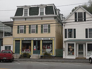
Wells River is a village in the town of Newbury in Orange County, Vermont, United States. The population was 431 at the 2020 census. The village center is located at the junction of U.S. Routes 5 and 302.

Athol is a town in Worcester County, Massachusetts, United States. The population was 11,945 at the 2020 census.

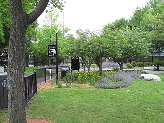
The North Loop is a neighborhood in the Central community of Minneapolis.
The Port, formerly Area 4, is a neighborhood of Cambridge, Massachusetts, roughly between Central Square, Inman Square, and MIT. It is bounded on the south by Massachusetts Avenue, on the west by Prospect Street, on the north by Hampshire Street, and on the east by the Grand Junction Railroad tracks. Area 4 is a densely populated residential neighborhood with about 7,000 residents.
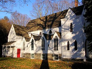
The Pine Meadow Historic District encompasses most of the historic 19th-century village of Pine Meadow in New Hartford, Connecticut, United States. Located at a bend in the West Branch of the Farmington River southeast of New Hartford center, it is a well-preserved example of a rural industrial village. The district was listed on the National Register of Historic Places in 1996.

The Millis Center Historic District is an historic district on Curve, Daniels, Exchange, Irving, Lavender, Main, and Union Streets in Millis, Massachusetts. It encompasses the historic mid-to-late-19th century village center of the town, including the residential area north of Main Street, two 19th-century industrial complexes, and civic and institutional buildings. It was added to the National Register of Historic Places in 2007.
The Chester Factory Village Historic District is a historic district encompassing the historic village of Chester Factories in Chester, Massachusetts. Chester was settled in the 1760s, and the factory village was a location where water power was harnessed at an early time for grist mills and sawmills. The village got its name from the Chester Glass Factory, which operated in the area through the War of 1812. It benefited from the construction of a turnpike leading to Chester Center in 1804, and was transformed by the arrival of the railroad around 1840. The village became an important provisioning stop for trains, and the village further benefited by the fact that the railroad bypassed Chester Center. The economic and civic life of the town gradually shifted, and Chester Factories is where the town hall and library were built. It was added to the National Register of Historic Places in 1989.

Shawsheen Village Historic District is a historic district in northern Andover, Massachusetts. Shawsheen Village was completed in the early 1920s as a planned corporate community. Conceived by William Madison Wood of the American Woolen Company, the village was designed a team of architects including Adden & Parker, Clifford Allbright and Ripley & LeBoutillier of Boston and James E. Allen of Lawrence. John Franklin, a civil engineer for the American Woolen Company was responsible for designing the village, under the direction of Wood. Buildings from the original Frye Village were also incorporated into the design which included a railroad station, shops, apartment buildings, factories, parks and numerous single-family dwellings. The village was located just up the road from the Company's main factories in nearby Lawrence.

The Kendal Green Historic District is a rural residential district running along North Avenue in Weston, Massachusetts. It extends for about three-quarters of a mile, and includes elements representative of the development of Weston from a rural agricultural community to a residential suburb of Boston. In addition to a variety of predominantly residential and agricultural properties, it includes two formerly industrial sites important in Weston's history: the site of the Hobbs Tannery, and that of the Hook and Hastings Organ Factory. The district was listed on the National Register of Historic Places in 2000.

The Central Square Historic District is a historic district encompassing much of the central business district of Stoneham, Massachusetts. It includes the town's largest concentration of 19th and early-20th century commercial architecture, in an area that developed in importance as a commercial center after the construction of the Andover-Medford Turnpike. The district was added to the National Register of Historic Places in 1990.

The Nashville Historic District in Nashua, New Hampshire is a historic district that was listed on the National Register of Historic Places (NRHP) in 1984. It encompasses an area just north of downtown Nashua, roughly centered on the junction of Concord, Amherst, and Main streets. Its southern bound is the Nashua River and Railroad Square, its eastern bounds are Railroad Square, Clinton, Lock, Orange, and Concord streets, its northern bound is Mount Pleasant Street, and its western boundary is Abbott, Amherst, Concord, and Main streets between the northern and southern bounds.

The Taftsville Historic District encompasses a historic 19th-century industrial village that is mostly in Woodstock, Vermont. Flanking the Ottauquechee River and extending up Happy Valley Road, the area developed around a metal tool factory established by members of the Taft family in 1793. Important elements from its early history include the Taftsville Store, built by the Taft family in 1840, and the Taftsville Covered Bridge, built in 1836. The district was listed on the National Register of Historic Places in 2001.
The Belvidere South State Street Historic District is a historic district on the north side of the Kishwaukee River in Belvidere, Illinois. It is primarily composed of commercial building representative of architectural trends from 1852 to 1962, the period following the connection of the city to the Galena and Chicago Union Railroad.

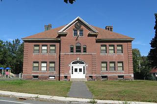
The Franklin Falls Historic District is a 75-acre (30 ha) historic district encompassing most of the civic and industrial heart of Franklin, New Hampshire, which saw its most significant development in the second half of the 19th century and the first decades of the 20th. The district is focused on Central Street between two crossings of the Winnipesaukee River, and includes Odell Park along with industrial properties along the bend in the river north of those two crossings, as well as a number of properties on adjacent streets south of Central Street. The district was listed on the National Register of Historic Places in 1982.

Frog Hollow is one of the neighborhoods of Hartford, Connecticut. It is a predominantly working-class residential area, bounded on the north by Capitol Avenue, the east by Lafayette Street, the south by Madison and Hamilton Streets, and on the west by Interstate 84. The neighborhood was developed between about 1850 and 1930, and still contains a remarkable concentration of residential housing from that period. The entire neighborhood, covering more than 150 acres (61 ha) and including more than 900 buildings, is listed on the National Register of Historic Places.

The Depot Square Historic District encompasses the historic commercial business district of Randolph, Vermont. Developed in the mid-19th century around the facilities of the Central Vermont Railway, the area features a high concentration of well-preserved Second Empire and late Victorian commercial architecture. It was listed on the National Register of Historic Places in 1975.

The Randolph Center Historic District encompasses the historic early town center of Randolph, Vermont. Established in 1783, it was later eclipsed by Randolph Village, which developed around the town's main railroad depot. The village now has a distinguished array of late 18th and early 19th-century architecture and is home to an academic campus now housing Vermont State University. It was listed on the National Register of Historic Places in 1974.

The Moran Square Historic District is a historic district encompassing an area of late 19th and early 20th-century industrial, commercial, and residential development in Fitchburg, Massachusetts. Centered on the triangular junction of East Main Street with Lunenburg and Summer Streets, this area developed as a secondary node apart from the city's main commercial district, in an area were several industrial plants were undergoing significant growth. The district was listed on the National Register of Historic Places in 2018.

The Pines Bridge Historic District encompasses a historic industrial and commercial village in North Haven, Connecticut. Located just west of the town green and centered around the Broadway bridge over the Quinnipiac River, the village developed first as a commercial hub around a 17th-century bridge at the site, and then as a small industrial village in the 19th century. Now mainly residential, it was listed on the National Register of Historic Places in 1988.

The East Bridgeport Historic District encompasses one of the best-preserved 19th-century neighborhoods of Bridgeport, Connecticut. Bounded by Arctic Street, East Main Street, the railroad tracks, and the Pequonnock River, this area was a planned development of Bridgeport promoter P.T. Barnum and landowner William H. Noble. Its development prompted the significant growth of industry and economic activity east of the Pequonnock River. The district was listed on the National Register of Historic Places in 1979.


