
Orekhovo is a Moscow Metro station in Orekhovo-Borisovo Severnoye District, Southern Administrative Okrug, Moscow. It is on the Zamoskvoretskaya Line, between Tsaritsyno and Domodedovskaya stations.

Domodedovskaya is a Moscow Metro station in Orekhovo-Borisovo Severnoye and Orekhovo-Borisovo Yuzhnoye districts, Southern Administrative Okrug, Moscow. It is on the Zamoskvoretskaya Line, between Orekhovo and Krasnogvardeyskaya stations.
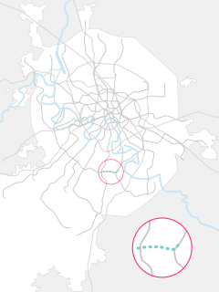
The Kakhovskaya line is a line of the Moscow Metro. Although the line was formed in 1995, all of the stations date to 1969 when they opened as part of the Zamoskvoretskaya line. The Kakhovskaya line is the only conventional line that lacks a full transfer to the ring line. It is also the shortest line in the system of only 3.3 kilometres (2.1 mi) in length and having only two stations.

Strogino, formerly known as Ostrogino (Острогино), is a district in North-Western Administrative Okrug of Moscow, Russia, located on the right bank of the Moskva River about 12 km west-northwest of central Moscow. An eponymous Moscow Metro station Strogino on the Arbatsko-Pokrovskaya Line was opened here on January 7, 2008. The Moscow Ring Road runs down the western border, and the Moskva River borders the district on the north and east. The area of the district is 18.643 square kilometres (7.198 sq mi). Population: 152,500

Yuzhnoye Butovo District is the biggest residential district in South-Western Administrative Okrug of Moscow, Russia. The district's history dates back to 1612, and it is named after a Don Cossack Butov. The area of the district is 27 square kilometres (10 sq mi). The population was 207,903.
Orekhovo-Borisovo Yuzhnoye District is a territorial division in Southern Administrative Okrug, one of the 125 in the federal city of Moscow, Russia. It is located in the south of the federal city. The area of the district is 7.197 square kilometers (2.779 sq mi). As of the 2010 Census, the total population of the district was 145,588.

The Suda is a river in Babayevsky, Kaduysky, and Cherepovetsky Districts of Vologda Oblast in Russia. It flows into the Rybinsk Reservoir of the Volga River. It is 184 kilometres (114 mi) long, with a drainage basin of 13,500 square kilometres (5,200 sq mi) and an average discharge of 134 cubic metres per second (4,700 cu ft/s). Its main tributaries are the Shogda, the Andoga, the Kolp, the Voron and the Petukh rivers.
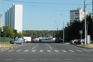
Kashirskoye Highway or Kashira Highway is a major street in Moscow, Russia, continued as a highway beyond the city into Moscow Oblast as a backup route for highway M4. It was named in the 19th century after the old Kashira Road, which led to the town of Kashira. It was one of the sites of the Russian apartment bombings of 1999. Along the road, major landmarks include the Saburovo Church and the Orekhovo-Borisovo Cathedral.
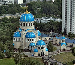
The Church of the Holy Trinity at the Borisovo Ponds is a metochion of the Patriarch of Moscow on the Kashira Highway in Orekhovo-Borisovo, a residential district in South Moscow. It was built in 2001-2004 to a Byzantine Revival design by Vladimir Kolosnitsyn, an architect favored by Mayor of Moscow, Yuri Luzhkov. Apart from the 70-metre-tall main church, the compound includes a chapel, a free-standing prothesis, a zvonnitsa, and a school. The interior has an icon screen made of porcelain and the academic wall paintings by Vasily Nesterenko. The church was originally slated to be erected in 1988, in commemoration of the millennium of the Baptism of Rus, but those plans did not materialize until 15 years later.

Babayevsky District is an administrative and municipal district (raion), one of the twenty-six in Vologda Oblast, Russia. It is located in the west of the oblast and borders with Vytegorsky District in the north, Belozersky District in the east, Kaduysky District in the southeast, Ustyuzhensky District in the south, Chagodoshchensky District in the southeast, and with Boksitogorsky, Tikhvinsky, and Podporozhsky Districts of Leningrad Oblast in the west. The area of the district is 9,200 square kilometers (3,600 sq mi). Its administrative center is the town of Babayevo. Population: 21,944 (2010 Census); 24,930 ; 29,535 (1989 Census). The population of Babayevo accounts for 55.0% of the district's total population.

Losinoostrovsky District is an administrative district (raion) of North-Eastern Administrative Okrug, and one of the 125 raions of Moscow, Russia. It is 14 km north of the Moscow city center, located just inside the Moscow Ring Road, with Moscow Oblast to the north, Severnoye Medvedkovo District to the west, Babushkinsky District to the south, and Yarosloavsky District to the east. The area of the district is 5.54 square kilometers (2.14 sq mi). Population: 72,100. Although its name coincides with Losiny Ostrov National Park, the district does not even border the park. Its name in fact refers to Losinoostrovskaya railway station, in turn named after the park.

Severnoye Medvedkovo District is an administrative district (raion) of North-Eastern Administrative Okrug, and one of the 125 raions of Moscow, Russia.

Sviblovo District is an administrative district (raion) of North-Eastern Administrative Okrug, and one of the 125 raions of Moscow, Russia. The area of the district is 4.41 square kilometers (1.70 sq mi).

Severnoye Tushino District or Northern Tushino is an administrative district (raion) of North-Western Administrative Okrug, and one of the 125 raions of Moscow, Russia. In the district there are Alyoshkinsky forest and Severnoye Tushino park.

Severnoye Izmaylovo District is one if 16 districts in the administrative district (raion) of Eastern Administrative Okrug, and one of the 125 raions of Moscow, Russia. It is bounded on the north by Shchelkovo Highway, on the south by Sirenevyy Boulevard, and on the east by the Moscow Ring Road (MKAD). The area of the district is 4 square kilometers (1.5 sq mi). Population: 85741 ;

Severnoye Butovo District is an administrative district (raion) of South-Western Administrative Okrug, and one of the 125 raions of Moscow, Russia. The area of the district is 9.271 square kilometers (3.580 sq mi). Population: 73,357.

Zyablikovo is a Moscow Metro station in the Zyablikovo District, Southern Administrative Okrug, Moscow. It is located on the Lyublinsko-Dmitrovskaya Line serving as its southern terminus.


