Troparyovo-Nikulino District

Last updated
Troparyovo-Nikulino District
Parko apud Vernadskij-avenuo.JPG
Park in Troparyovo-Nikulino District
Flag of Troparevo-Nikulino (municipality in Moscow).svg
Flag
Coat of Arms of Troparevo-Nikulino (municipality in Moscow).svg
Coat of arms
Location of Troparyovo-Nikulino District on the map of Moscow
Coordinates: 55°39′24″N37°28′15″E / 55.65667°N 37.47083°E / 55.65667; 37.47083
Country Russia
Federal subject Moscow
Area
[1]
  Total11.26 km2 (4.35 sq mi)
Population
  Estimate 
(2018) [2]
123,478
Time zone UTC+3 (MSK Blue pencil.svg [3] )
OKTMO ID45327000
Website http://troparevo-nikulino.mos.ru/

Troparyovo-Nikulino District is an administrative district (raion) at the southern edge of Western Administrative Okrug, and one of the 125 raions of Moscow, Russia. [4] The western border is the Moscow Ring Road, and the southern border is Leninsky Prospekt. The area of the district is 11.26 square kilometers (4.35 sq mi) [1] . Population: 119,000 (2016 est.)

A raion is a type of administrative unit of several post-Soviet states. The term is from the French "rayon", which is both a type of a subnational entity and a division of a city, and is commonly translated in English as "district".

Western Administrative Okrug, or Zapadny Administrative Okrug, is one of the twelve high-level territorial divisions of the federal city of Moscow, Russia. As of the 2010 Census, its population was 1,285,914, up from 1,049,104 recorded during the 2002 Census.

Moscow Capital city of Russia

Moscow is the capital and most populous city of Russia, with 13.2 million residents within the city limits, 17 million within the urban area and 20 million within the metropolitan area. Moscow is one of Russia's federal cities.

Contents

Education

The German School Moscow is located in Troparyovo-Nikulino District. [5]

German School Moscow

The German School Moscow "Friedrich-Joseph Haass" is a German-language private school in Troparyovo-Nikulino District, Western Administrative Okrug, Moscow, Russia. The Foreign Office and the Central Administration of German Schools Abroad support the school.

Other education organizations:

Moscow State University of Fine Chemical Technologies University in Moscow, Russia

Moscow State University of Fine Chemical Technologies named after M.V. Lomonosov is one of the oldest universities in the country that offer training in a wide range of specialties in the field of chemical technology.

The Russian Presidential Academy of National Economy and Public Administration under the President of the Russian Federation or RANEPA, is the largest federal state-funded institution of higher professional education located in Moscow, Russia.

Famous buildings

Industrial tourism is tourism in which the desired destination includes industrial sites peculiar to a particular location. The concept is not new, but has taken on renewed interest in recent times, with both industrial heritage sites and modern industry attracting tourism.

Borders of Troparyovo-Nikulin District, from OpenStreetMap Troparevo-Nikulino district map.jpg
Borders of Troparyovo-Nikulin District, from OpenStreetMap

See also

Related Research Articles

Beskudnikovsky District District in Moscow, Russia

Beskudnikovsky District is an administrative district (raion) of Northern Administrative Okrug, and one of the 125 raions of Moscow, Russia. The district is about 12 km north of Central Moscow, and has an area of 3.27 square kilometers (1.26 sq mi). Population: 64,000

Altufyevsky District District in Moscow, Russia

Altufyevsky District is an administrative district (raion) of North-Eastern Administrative Okrug, and one of the 125 raions of Moscow, Russia.

Marfino District District in Moscow, Russia

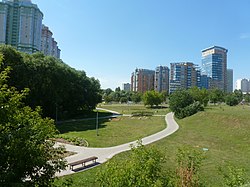
Marfino District is an administrative district (raion) of North-Eastern Administrative Okrug, and one of the 125 raions of Moscow, Russia. It is 8 km north of Moscow city center; to the east is Moscow's Central Botanical Gardens and the Ostankino Park. To the west is Butyrsky District. The area of the district is 2.7 square kilometers (1.0 sq mi). Population: 34,500

Severnoye Medvedkovo District District in Moscow, Russia

Severnoye Medvedkovo District is an administrative district (raion) of North-Eastern Administrative Okrug, and one of the 125 raions of Moscow, Russia.

Sviblovo District District in Moscow, Russia

Sviblovo District is an administrative district (raion) of North-Eastern Administrative Okrug, and one of the 125 raions of Moscow, Russia. The area of the district is 4.41 square kilometers (1.70 sq mi). Moscow Botanical Garden is located in Sviblovo.

Yaroslavsky District, Moscow District in Moscow, Russia

Yaroslavsky District, Moscow is an administrative district (raion) of North-Eastern Administrative Okrug, and one of the 125 raions of Moscow, Russia. The area of the district is 7.99 square kilometers (3.08 sq mi). The district is situated on both sides of a major highway, Yaroslavskoye shosse, east from Yaroslavsky railway, and is named after both. The Moscow State Construction University is located in this district at 26 Yaroslavsky Highway.

Pokrovskoye-Streshnevo District District in Moscow, Russia

Pokrovskoye-Streshnevo District is an administrative district (raion) of North-Western Administrative Okrug, and one of the 125 raions of Moscow, Russia.

Yuzhnoye Tushino District District in Moscow, Russia

Yuzhnoye Tushino District is an administrative district (raion) of North-Western Administrative Okrug, and one of the 125 raions of Moscow, Russia.

Ivanovskoye District District in Moscow, Russia

Ivanovskoye District is an administrative district (raion) of Eastern Administrative Okrug, and one of the 125 raions of Moscow, Russia.

Perovo District District in Moscow, Russia

Perovo District is an administrative district (raion) of Eastern Administrative Okrug, and one of the 125 raions of Moscow, Russia.

Vostochny District, Moscow District in Moscow, Russia

Vostochny District, Moscow is an administrative district (raion) of Eastern Administrative Okrug, and one of the 125 raions of Moscow, Russia.

Fili-Davydkovo District District in Moscow, Russia

Fili-Davydkovo District is an administrative district (raion) of Western Administrative Okrug, and one of the 125 raions of Moscow, Russia.

Novo-Peredelkino District District in Moscow, Russia

Novo-Peredelkino District is an administrative district (raion) of Western Administrative Okrug, and one of the 125 raions of Moscow, Russia.

Prospekt Vernadskogo District District in Moscow, Russia

Prospekt Vernadskogo District is an administrative district (raion) of Western Administrative Okrug, and one of the 125 raions of Moscow, Russia. The area of the district is 4.6154 square kilometers (1.7820 sq mi). Population: 62,000,

Vnukovo District District in Moscow, Russia

Vnukovo District is an administrative district (raion) of Western Administrative Okrug, and one of the 125 raions of Moscow, Russia. Most of the district is occupied by Vnukovo International Airport, a small adjacent residential area, and a separate residential micro-district. The area of the district is 16.912 square kilometers (6.530 sq mi). Population: 20,100.

Chertanovo Tsentralnoye District District in Moscow, Russia

Chertanovo Tsentralnoye District is an administrative district (raion) of Southern Administrative Okrug, and one of the 125 raions of Moscow, Russia.

Chertanovo Yuzhnoye District District in Moscow, Russia

Chertanovo Yuzhnoye District is an administrative district (raion) of Southern Administrative Okrug, and one of the 125 raions of Moscow, Russia.

Moskvorechye-Saburovo District District in Moscow, Russia

Moskvorechye-Saburovo District is an administrative district (raion) of Southern Administrative Okrug, and one of the 125 raions of Moscow, Russia. The area of the district is 9.30 square kilometers (3.59 sq mi).

Kotlovka District District in Moscow, Russia

Kotlovka District is an administrative district (raion) of South-Western Administrative Okrug, and one of the 125 raions of Moscow, Russia. The area of the district is 3.865 square kilometers (1.492 sq mi). Population: 54,200.

Lomonosovsky District, Moscow District in Moscow, Russia

Lomonosovsky District, Moscow is an administrative district (raion) of South-Western Administrative Okrug, and one of the 125 raions of Moscow, Russia. The area of the district is 3.34 square kilometers (1.29 sq mi). Population: 85,000 . Population - 81,851. Established at 1995. Named after Mikhail Vasilyevich Lomonosov.

References

Notes

  1. 1 2 "General Information" (in Russian). Troparyovo-Nikulino District. Retrieved April 12, 2018.
  2. "26. Численность постоянного населения Российской Федерации по муниципальным образованиям на 1 января 2018 года". Federal State Statistics Service. Retrieved 23 January 2019.
  3. "Об исчислении времени". Официальный интернет-портал правовой информации (in Russian). 3 June 2011. Retrieved 19 January 2019.
  4. Государственный комитет Российской Федерации по статистике. Комитет Российской Федерации по стандартизации, метрологии и сертификации. №ОК 019-95 1 января 1997 г. «Общероссийский классификатор объектов административно-территориального деления. Код 45», в ред. изменения №278/2015 от 1 января 2016 г.. (State Statistics Committee of the Russian Federation. Committee of the Russian Federation on Standardization, Metrology, and Certification. #OK 019-95 January 1, 1997 Russian Classification of Objects of Administrative Division . Code 45, as amended by the Amendment #278/2015 of January 1, 2016. ).
  5. "Contact." German School Moscow. Retrieved on 31 October 2011. "Address: German School Moscow Prospekt Vernadskogo 103 / 5 119526 Moscow Russian Federation " - Address in German: "Deutsche Schule Moskau Prospekt Wernadskogo 103 / 5 119526 Moskau Russische Föderation" - Address in Russian: "Немецкая школа в Москве проспект Вернадского 103 / 5 119526 Москва Российская Федерация "

Sources

Coordinates: 55°39′36″N37°27′56″E / 55.66000°N 37.46556°E / 55.66000; 37.46556

Geographic coordinate system Coordinate system

A geographic coordinate system is a coordinate system that enables every location on Earth to be specified by a set of numbers, letters or symbols. The coordinates are often chosen such that one of the numbers represents a vertical position and two or three of the numbers represent a horizontal position; alternatively, a geographic position may be expressed in a combined three-dimensional Cartesian vector. A common choice of coordinates is latitude, longitude and elevation. To specify a location on a plane requires a map projection.