Golyanovo District

Last updated

Coordinates: 55°49′14″N37°48′26″E / 55.82056°N 37.80722°E / 55.82056; 37.80722

Geographic coordinate system Coordinate system

A geographic coordinate system is a coordinate system that enables every location on Earth to be specified by a set of numbers, letters or symbols. The coordinates are often chosen such that one of the numbers represents a vertical position and two or three of the numbers represent a horizontal position; alternatively, a geographic position may be expressed in a combined three-dimensional Cartesian vector. A common choice of coordinates is latitude, longitude and elevation. To specify a location on a plane requires a map projection.

Golyanovo District
Goliyanovo, Moscow - 501.jpg
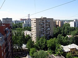
Neighborhood in Golyanovo District
Flag of Goliyanovo (municipality in Moscow).png
Flag
Coat of Arms of Goliyanovo (municipality in Moscow).png
Coat of arms
Location of Golyanovo District on the map of Moscow
Coordinates: 55°49′14″N37°48′26″E / 55.82056°N 37.80722°E / 55.82056; 37.80722
Country Russia
Federal subject Moscow
Area
  Total149,902 km2 (57,877 sq mi)
Population
  Estimate 
(2018) [1]
162,715
Time zone UTC+3 (MSK Blue pencil.svg [2] )
OKTMO ID45305000
Website http://golyanovo.mos.ru/

Golyanovo District (Russian : райо́н Голья́ново) is a district of Eastern Administrative Okrug of the federal city of Moscow, Russia. Population: 157,040(2010 Census); [3] 159,147(2002 Census). [4]

Russian language East Slavic language

Russian is an East Slavic language, which is official in the Russian Federation, Belarus, Kazakhstan and Kyrgyzstan, as well as being widely used throughout Eastern Europe, the Baltic states, the Caucasus and Central Asia. It was the de facto language of the Soviet Union until its dissolution on 25 December 1991. Although, nowadays, nearly three decades after the breakup of the Soviet Union, Russian is used in official capacity or in public life in all the post-Soviet nation-states, as well as in Israel and Mongolia, the rise of state-specific varieties of this language tends to be strongly denied in Russia, in line with the Russian World ideology.

Administrative divisions of Moscow

The federal city of Moscow, Russia is divided into twelve administrative okrugs, which are in turn subdivided into districts (raions). The city does not have a downtown area; the urban core is scattered across the city. Prominent business areas include Tverskoy, Arbat, and Presnensky Districts. Central Administrative Okrug as a whole has a large concentration of businesses. The city hall and major administration buildings are located in Tverskoy District. Western Administrative Okrug is home to Moscow State University, Sparrow Hills and Mosfilm Studios, while North-Eastern hosts Ostankino Tower and VDNKh Exhibition Park. The total population of the Federal City of Moscow was 11,503,501 inhabitants at the Russian Census (2010).

Eastern Administrative Okrug Administrative okrug of Moscow in Russia

Eastern Administrative Okrug, or Vostochny Administrative Okrug, is one of the twelve high-level territorial divisions of the federal city of Moscow, Russia. As of the 2010 Census, its population was 1,452,759, up from 1,394,497 recorded during the 2002 Census.

It is one of the largest districts in Moscow, both in terms of the geographic area and population size. Located 9-15 km to the east of the Kremlin, this large territory is bounded by MKAD (Moscow Automobile Ring Road), Shchyolkovskoye Shosse, and the national park "Losiny Ostrov".

Golyanovo is named after minnow (golyan in Russian), which was once abundant in the local lakes. The first mention of Golyanovo dates back to the 17th century. Golyanovo was incorporated into the city of Moscow in the early 1960s. At approximately the same time, city officials started massive construction projects in the district, building numerous microdistricts. [5]

Microdistrict residential complex—a primary structural element of the residential area construction in the Soviet Union

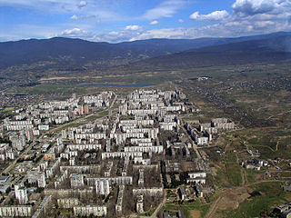
Microdistrict, or microraion is a residential complex—a primary structural element of the residential area construction in the Soviet Union and in some post-Soviet and former Communist states. Residential districts in most of the cities and towns in Russia and the republics of the former Soviet Union were built in accordance with this concept.

Related Research Articles

Tagansky District human settlement in Russia

Tagansky District is a district of Central Administrative Okrug of the federal city of Moscow, Russia, located between the Moskva and Yauza Rivers near the mouth of the latter. Population: 116,744 (2010 Census); 109,993 (2002 Census).

Arbat District human settlement in Russia

Arbat District is a district of Central Administrative Okrug of the federal city of Moscow, Russia. Population: 28,179 (2010 Census); 25,699 (2002 Census).

Ramenki District District in Moscow, Russia

Ramenki District is a district in Western Administrative Okrug of the federal city of Moscow, Russia. The area of the district is 18.76 square kilometres (7.24 sq mi) . Population: 126,000 125,128 (2010 Census); 101,485 (2002 Census).

Lesnoy, Pushkinsky District, Moscow Oblast Urban-type settlement in Moscow Oblast, Russia


Lesnoy is an urban locality in Pushkinsky District of Moscow Oblast, Russia, located 42 kilometers (26 mi) northeast from Moscow on the road to Yaroslavl and Arkhangelsk. Population: 8,569 (2010 Census); 8,761 (2002 Census); 9,296 (1989 Census).

Bykovo, Ramensky District, Moscow Oblast Urban-type settlement in Moscow Oblast, Russia

Bykovo is an urban locality in Ramensky District of Moscow Oblast, located 34 kilometers (21 mi) southeast of Moscow. Population: 10,391 (2010 Census); 9,235 (2002 Census); 10,395 (1989 Census).

Iksha Urban-type settlement in Moscow Oblast, Russia

Iksha is an urban locality in Dmitrovsky District of Moscow Oblast, Russia, located 45 kilometers (28 mi) north of Moscow along the Dmitrov highway and the Moscow Canal, and is a junction of the Savyolovo Railway. Population: 3,721 (2010 Census); 3,738 (2002 Census); 4,619 (1989 Census).

Barvikha is a rural locality in Odintsovsky District of Moscow Oblast, Russia. Population: 4,093 (2010 Census); 4,228 (2002 Census).

Povarovo, Moscow Oblast Urban-type settlement in Moscow Oblast, Russia

Povarovo is an urban locality in Solnechnogorsky District of Moscow Oblast, Russia, located 30 kilometers (19 mi) from the federal city of Moscow. Population: 7,985 (2010 Census); 7,602 (2002 Census); 9,066 (1989 Census).

Balashikhinsky District was an administrative and municipal district (raion) of Moscow Oblast, Russia. Its administrative center was the city of Balashikha. Population: 225,381 (2010 Census); 187,988 (2002 Census); 31,964 (1989 Census). The population of Balashikha accounted for 95.6% of the district's total population.

Zyuzino is a rural locality in the Ramensky District in Moscow Oblast, Russia. Population: 1,036 (2010 Census); 851 (2002 Census);

Bolshiye Vyazyomy Urban-type settlement in Moscow Oblast, Russia

Bolshiye Vyazyomy is an urban locality in Odintsovsky District of Moscow Oblast, Russia. The population is 12,650 (2010 Census); 5,667 (2002 Census);

Uvarovka Urban-type settlement in Moscow Oblast, Russia

Uvarovka is an urban locality in Mozhaysky District of Moscow Oblast, Russia. Population: 3,354 (2010 Census); 3,162 (2002 Census); 3,675 (1989 Census).

Beloozyorsky Urban-type settlement in Moscow Oblast, Russia

Beloozyorsky is an urban locality in Voskresensky District of Moscow Oblast, Russia. Population: 17,842 (2010 Census); 14,494 (2002 Census); 11,866 (1989 Census).

Selyatino Urban-type settlement in Moscow Oblast, Russia

Selyatino is an urban locality in Naro-Fominsky District of Moscow Oblast, Russia. Population: 12,629 (2010 Census); 13,062 (2002 Census);

Rzhavki Urban-type settlement in Moscow Oblast, Russia

Rzhavki is an urban locality in Solnechnogorsky District of Moscow Oblast, Russia. Population: 4,038 (2010 Census); 4,118 (2002 Census);

Obolensk, Moscow Oblast Urban-type settlement in Moscow Oblast, Russia

Obolensk is an urban locality in Serpukhovsky District of Moscow Oblast, Russia. Population: 4,937 (2010 Census); 5,458 (2002 Census);

Sychyovo Urban-type settlement in Moscow Oblast, Russia

Sychyovo is an urban locality in Volokolamsky District of Moscow Oblast, Russia. Population: 3,105 (2010 Census); 3,195 (2002 Census); 3,007 (1989 Census).

Verbilki Urban-type settlement in Moscow Oblast, Russia

Verbilki is an urban locality in Taldomsky District of Moscow Oblast, Russia. Population: 7,022 (2010 Census); 6,764 (2002 Census); 8,361 (1989 Census).

LMS is a settlement in Troitsky Administrative Okrug of the federal city of Moscow, Russia. Population: 5,238 (2010 Census); 5,414 (2002 Census);

Kartmazovo is a rural locality (a in Moskovsky Settlement of Moscow, Russia. Population: 308  ; 99  ;

References

  1. "26. Численность постоянного населения Российской Федерации по муниципальным образованиям на 1 января 2018 года". Federal State Statistics Service. Retrieved 23 January 2019.
  2. "Об исчислении времени". Официальный интернет-портал правовой информации (in Russian). 3 June 2011. Retrieved 19 January 2019.
  3. Russian Federal State Statistics Service (2011). "Всероссийская перепись населения 2010 года. Том 1" [2010 All-Russian Population Census, vol. 1]. Всероссийская перепись населения 2010 года [2010 All-Russia Population Census] (in Russian). Federal State Statistics Service.
  4. Russian Federal State Statistics Service (21 May 2004). "Численность населения России, субъектов Российской Федерации в составе федеральных округов, районов, городских поселений, сельских населённых пунктов – районных центров и сельских населённых пунктов с населением 3 тысячи и более человек" [Population of Russia, Its Federal Districts, Federal Subjects, Districts, Urban Localities, Rural Localities—Administrative Centers, and Rural Localities with Population of Over 3,000](XLS). Всероссийская перепись населения 2002 года [All-Russia Population Census of 2002] (in Russian).
  5. "General Information" (in Russian). Golyanovo District. Retrieved March 27, 2018.