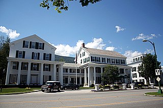
Manchester is an incorporated village in the town of Manchester, Bennington County, Vermont, United States. The population was 783 at the 2020 census.

Commonwealth Avenue is a major street in the cities of Boston and Newton, Massachusetts. It begins at the western edge of the Boston Public Garden, and continues west through the neighborhoods of the Back Bay, Kenmore Square, Boston University, Allston, Brighton and Chestnut Hill. It continues as part of Route 30 through Newton until it crosses the Charles River at the border of the town of Weston.
The Garden District is a residential neighborhood located in Baton Rouge's Mid-City area where Park Boulevard intersects Government Street. The Garden District is an established historic area with many upscale homes and an active civic association.
Henry Wright, was a planner, architect, and major proponent of the garden city, an idea characterized by green belts and created by Sir Ebenezer Howard.

Alewife Brook Parkway is a short parkway in Cambridge and Somerville, Massachusetts. It is listed on the National Register of Historic Places. It begins at Fresh Pond in Cambridge, and heads north on the east bank of Alewife Brook, crossing into West Somerville and ending at the Mystic River on the Medford town line, where it becomes Mystic Valley Parkway. The entire length of Alewife Brook Parkway is designated as part of Massachusetts Route 16 (Route 16), while the southernmost sections are also designated as part of Route 2 and U.S. Route 3 (US 3). It is managed by the Department of Conservation and Recreation with the Massachusetts Department of Transportation responsible for bridge maintenance.
Columbus, the state capital and Ohio's largest city, has numerous neighborhoods within its city limits. Neighborhood names and boundaries are not officially defined. They may vary or change from time to time due to demographic and economic variables.

The Truman Parkway is a historic parkway in Milton and southern Boston, Massachusetts. It runs along the southern boundary of a portion of the Neponset River Reservation and serves as a connection between the Neponset Valley Parkway and the Blue Hills Parkway. The parkway was built in 1931 and added to the National Register of Historic Places in 2005.

The Middlesex Fells Reservation Parkways are the roadways within and bordering on the Middlesex Fells Reservation, a state park in the northern suburbs of Boston, Massachusetts, United States. The park includes portions of the towns of Malden, Medford, Melrose, Stoneham, and Winchester. The roads inside the park and around its perimeter have been listed on the National Register of Historic Places. Other portions of some of the roads are covered by more than one listing in the national register; see Fellsway Connector Parkways and Middlesex Fells Reservoirs Historic District.

The Call-Bartlett House is a historic house in Arlington, Massachusetts. Built in 1855, it is one of the town's finest examples of Greek Revival architecture. The house was listed on the National Register of Historic Places in 1985.

The Kensington Park Historic District of Arlington, Massachusetts encompasses a turn of the 20th century planned residential subdivision in the hills above the town center, representing an early phase in the town's transition from a rural to suburban setting. The district consists of most of the houses on Brantwood and Kensington Roads, which wind around a rocky hillside overlooking Pleasant Street and Spy Pond, just west of the center. A number of the houses are the work of architect C. Herbert McClare, who also lived in the area, and was one of the development's proponents. The district was listed on the National Register of Historic Places in 1985.
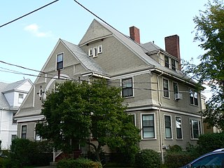
The House at 5–7 Winter Street in Arlington, Massachusetts is a rare late-19th century two family house in East Arlington. The wood-frame house was built in 1895 by John Squires, who owned a garden farm. It was built as a speculative venture at a time before Arlington's market gardeners began selling their land off for development. The building exhibits well-preserved Queen Anne styling, with asymmetric massing characteristic of that style, and a judicious use of decorative cut wood shingles.

The Wedgemere Historic District encompasses the largest single 19th-century residential development of Winchester, Massachusetts. It is one of the town's largest surviving 19th-century residential subdivisions, with a concentration of high-quality residences built between about 1890 and 1920. The district was listed on the National Register of Historic Places in 1989.

The Monadnock Road Historic District is a residential historic district encompassing a cohesive subdivision of a former estate in the 1920s in the Chestnut Hill section of Newton, Massachusetts. The development was typical of Newton's explosive residential growth at that time, and includes primarily Tudor Revival houses. The district was listed on the National Register of Historic Places in 1990.

Blue Hills Parkway is a historic parkway that runs in a straight line from a crossing of the Neponset River, at the south border of Boston to the north edge of the Blue Hills Reservation in Milton, Massachusetts. It was built in 1893 to a design by the noted landscape architect, Charles Eliot, who is perhaps best known for the esplanades along the Charles River. The parkway is a connecting road between the Blue Hills Reservation and the Neponset River Reservation, and was listed on the National Register of Historic Places in 2003.

The Cypress–Emerson Historic District encompasses a residential area on the west side of Brookline Village in Brookline, Massachusetts, United States. Centered on Waverly and Cypress Streets, and including Emerson Park, this area was developed in the post-Civil War era, its growth matching that of the commercial areas of the village. The district was listed on the National Register of Historic Places in 1985.

The Fisher Hill Historic District encompasses a residential area in central Brookline, Massachusetts. The area was subdivided and built out beginning in the 1880s, with landscaping design by Frederick Law Olmsted and John Charles Olmsted. The district is bounded on the west by Chestnut Hill Avenue, Baxter Road, and Channing Road, and on the south by Massachusetts Route 9. Its eastern boundary runs along Buckminster Street to Dean Road, joining the northern boundary of Clinton Road, running between Dean Road and Chestnut Hill Avenue. Prior to its development in the 1880s, Fisher Hill had a relatively small number of landowners. Some of them banded together, hiring the Olmsteds to design a subdivision plan for the entire district. Lots were sold to wealthy individuals, who built fashionable houses, often designed by architects. In 1914 a restrictive covenant was entered into by a significant number of property owners, restricting their properties to strictly single-family residential uses.
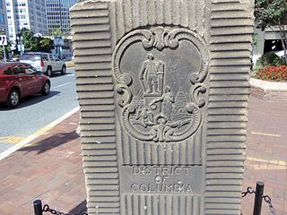
The Garden Club of America Entrance Markers in Washington, D.C., are carven stone pylons installed along the border of the District of Columbia in 1932 and 1933 by local Garden Club of America chapters. Originally about five feet tall, the markers were placed at important entrance points to the national capital. Seven survive: sets of two markers in Westmoreland Circle, Friendship Heights, and Chevy Chase Circle; and a single marker along Georgia Avenue. These surviving markers are listed on the National Register of Historic Places.

The Riverview Park Plat Historic District is located in the north-central section of Des Moines, Iowa, United States. It has been listed on the National Register of Historic Places since 1996.
The Little Boar's Head Historic District encompasses an area of summer resort and beachfront properties in North Hampton, New Hampshire. Located on New Hampshire's seacoast roughly between North Hampton State Beach and Bass Beach, the district is almost entirely residential, consisting mainly of houses built as summer vacation spots in the late 19th and early 20th centuries, with associated beachfront amenities. The district was listed on the National Register of Historic Places in 1999.

The West End North Historic District encompasses a neighborhood of late 19th and early 20th century residential architecture in western Hartford, Connecticut and eastern West Hartford, Connecticut. Roughly bounded by Prospect, Elizabeth, and Lorraine Streets and Farmington Avenue, the area includes a large number of Colonial Revival and Queen Anne houses, as well as numerous buildings in other period styles, with only a small number of losses. It was listed on the National Register of Historic Places in 1985.


