BapaumeFrench pronunciation: [bapom](listen) is a commune in the Pas-de-Calais department in the Hauts-de-France region of northern France.

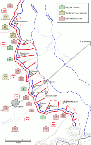
The first day on the Somme, 1 July 1916, was the beginning of the Battle of Albert (1–13 July), the name given by the British to the first two weeks of the 141 days of the Battle of the Somme in the First World War. Nine corps of the French Sixth Army and the British Fourth and Third armies attacked the German 2nd Army from Foucaucourt south of the Somme, northwards across the Somme and the Ancre to Serre and at Gommecourt, 2 mi (3.2 km) beyond, in the Third Army area. The objective of the attack was to capture the German first and second defensive positions from Serre south to the Albert–Bapaume road and the first position from the road south to Foucaucourt.
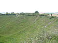
The Lochnagar mine south of the village of La Boisselle in the Somme département was an underground explosive charge, secretly planted by the British during the First World War, to be ready for 1 July 1916, the first day on the Somme. The mine was dug by the Tunnelling Companies of the Royal Engineers under a German field fortification known as Schwabenhöhe.

The Grimsby Chums was a British First World War Pals battalion of Kitchener's Army raised in and around the town of Grimsby in Lincolnshire in 1914. When the battalion was taken over by the British Army it was officially named the 10th (Service) Battalion, The Lincolnshire Regiment. It was the only 'pals battalion' to be called 'chums'.
The Battle of Albert is the British name for the first two weeks of British–French offensive operations of the Battle of the Somme. The Allied preparatory artillery bombardment commenced on 24 June and the British–French infantry attacked on 1 July, on the south bank from Foucaucourt to the Somme and from the Somme north to Gommecourt, 2 mi (3.2 km) beyond Serre. The French Sixth Army and the right wing of the British Fourth Army inflicted a considerable defeat on the German 2nd Army but from near the Albert–Bapaume road to Gommecourt, the British attack was a disaster, where most of the c. 57,000 British casualties of the day were incurred. Against the wishes of General Joseph Joffre, General Sir Douglas Haig abandoned the offensive north of the road to reinforce the success in the south, where the British–French forces pressed forward through several intermediate lines closer to the German second position.
Flers is a commune near the northern edge of the Somme department in Hauts-de-France in northern France.

Pozières is a commune in the Somme department in Hauts-de-France in northern France.
Peter Arthur Barton is a British military historian, author and filmmaker specialising in trench warfare during World War I. He has published extensively on military mining and aspects of battlefield archaeology on the Western Front, and led archaeological excavations that have been featured in several Time Team episodes. His work has led to the rediscovery of many tunnels, wartime panoramas and mass graves of soldiers.

Longueval is a commune in the Somme department in Hauts-de-France in northern France.
The Capture of La Boisselle was a tactical incident during the Battle of Albert, the name given by the British to the first two weeks of the Battle of the Somme. The village of La Boisselle forms part of the small commune of Ovillers-la-Boisselle about 22 mi (35 km) north-east of Amiens in the Somme department in Picardie in northern France. To the north-east of La Boisselle lies Ovillers; by 1916, the village was called Ovillers by the British Expeditionary Force (BEF) to avoid confusion with La Boisselle, south of the road.
The 174th Tunnelling Company was one of the tunnelling companies of the Royal Engineers created by the British Army during World War I. The tunnelling units were occupied in offensive and defensive mining involving the placing and maintaining of mines under enemy lines, as well as other underground work such as the construction of deep dugouts for troop accommodation, the digging of subways, saps, cable trenches and underground chambers for signals and medical services.
The 179 Tunnelling Company was one of the tunnelling companies of the Royal Engineers created by the British Army during World War I. The tunnelling units were occupied in offensive and defensive mining involving the placing and maintaining of mines under enemy lines, as well as other underground work such as the construction of deep dugouts for troop accommodation, the digging of subways, saps, cable trenches and underground chambers for signals and medical services. 179th Tunnelling Company is particularly known for its role at L'îlot de La Boisselle and for firing the Lochnagar mine during the Battle of the Somme 1916. The Lochnagar mine formed part of a series of 19 mines that were placed beneath the German lines on the British section of the Somme front to assist the start of the battle.
The 185th Tunnelling Company was one of the tunnelling companies of the Royal Engineers created by the British Army during World War I. The tunnelling units were occupied in offensive and defensive mining involving the placing and maintaining of mines under enemy lines, as well as other underground work such as the construction of deep dugouts for troop accommodation, the digging of subways, saps, cable trenches and underground chambers for signals and medical services.
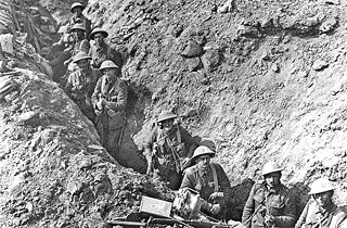
On the morning of 1 July 1916, the first day of the Battle of the Somme during World War I, underground explosive charges planted by British tunnelling units were detonated beneath the German front lines. The joint explosion of these mines ranks among the largest artificial non-nuclear explosions.
The Capture of Ovillers was a British local operation during the Battle of Albert, the name given by the British to the first two weeks of the Battle of the Somme. The village of Ovillers-la-Boisselle forms part of the small commune of Ovillers-la-Boisselle, located some 22 mi (35 km) north-east of Amiens in the Somme department in Picardie in northern France. By 1916, the village was called Ovillers by the British Expeditionary Force (BEF) to avoid confusion with La Boisselle south of the road. To the south-west of Ovillers lies La Boisselle.
L'îlot de La Boisselle is a small, 3.12-hectare (7.7-acre) historic site in the commune of Ovillers-la-Boisselle in the Somme department in Picardie in northern France. L'îlot was heavily fought over during the First World War, when it was known as Granathof to the Germans and as Glory Hole to British soldiers. The site is private property and open to the public by appointment with Claudie LLewellyn.

In World War I, the small commune of Ovillers-la-Boisselle, located some 22 miles (35 km) north-east of Amiens in the Somme department in Hauts-de-France in northern France, was the site of intense and sustained fighting between German and Allied forces. Between 1914 and 1916, the Western Front ran through the commune, and the villages were completely destroyed. After the Armistice of 11 November 1918, the former inhabitants returned and gradually rebuilt most of the infrastructure as it had been before the war.
The Y Sap mine was an underground explosive charge, secretly planted by the British during the First World War and ready for 1 July 1916, the first day on the Somme. The mine was dug by the Tunnelling Companies of the Royal Engineers under a German machine-gun nest known as Blinddarm (appendix) in the front line, on the north side of the village of La Boisselle in the Somme département. The mine was named after Y Sap, the British trench from which the gallery was driven. It was one of 19 mines on the British sector to be blown at the start of the battle.
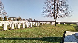
The Bapaume Post Military Cemetery is a cemetery located in the Somme region of France commemorating British and Commonwealth soldiers who fought in the Battle of the Somme in World War I. The cemetery honors mainly those who were killed in the 1 July 1916 attack on the village of La Boiselle, those who died defending the line in the areas east and west of the cemetery, and those who died retaking the village and the surrounding area in August 1918.