Eight big and eleven tiny charges were buried deep in the chalky earth to make up the 19 mines. They were "overcharged" to throw up high lips for screening and to give advantage to the attackers if they were able to capture the resulting craters.[1] The larger mines were located near Beaumont-Hamel beneath Hawthorn Ridge Redoubt and near La Boisselle (Lochnagar, Y Sap, and Glory Hole charges), Fricourt (Triple Tambour mines), Bulgar Point and Kasino Point. The smaller charges for removing German positions, such as machine gun posts, were laid from the ends of comparatively shallow tunnels.
In addition to the mines, the British tunnelling units also prepared a series of shallow saps extending from the British positions into the no man's land. They allowed the infantry to attack the Germans from a comparatively short distance once the battle commenced.[1]
When they were fired, the Lochnagar and Hawthorn Ridge mines were the largest ever detonated, and reports suggest that their sound could be heard in London and beyond. The mine detonations on the first day of the Somme were surpassed by those fired at the start of the Battle of Messines the following year.
A mine gallery with timber roof support (Canada 2003)
Miners laying charges for one of the mines on the Somme, 1–13 July 1916.
Map of chalk areas in northern France
Geological cross-section of the Somme battlefield
1914
French and German military operations began on the Somme in September 1914. After the German advance towards Albert had been brought to a halt at La Boisselle and attempts to resume offensive warfare in October had not been successful, both sides reduced their attacks to local operations or raids and began to fortify their remaining positions with underground works. On 18 December, the French captured La Boisselle's village cemetery at the west end of a German salient and established an advanced post only 3 metres (3.3yd) from the German front line. By 24 December, the French forced the Germans back from the cemetery and the western area of La Boisselle[2] but their advance was stopped a short distance forward at L'îlot de La Boisselle, in front of German trenches protected by barbed wire. Once the location of a farm and a small number of buildings, L'îlot became known as Granathof (German: "shell farm") to the Germans and later as Glory Hole to the British. On Christmas Day 1914, French engineers sank a first mine shaft at La Boisselle. Local but heavy fighting underground also took place in the winter of 1914 and spring of 1915 at Fricourt, Bois Français and Carnoy.[3]
1915
From January 1915 to the start of the Battle of the Somme in July 1916, L'îlot de La Boisselle was the scene of fierce underground fighting. Having started mining at La Boisselle shortly after the French, the Bavarian Engineer Regiment 1 continued digging eight galleries towards L'îlot. On 5 January, French sappers were heard digging near a gallery and a 300-kilogram (660lb)camouflet was quickly placed in the gallery and blown, collapsing the French digging and two German galleries in the vicinity. A 600-kilogram (1,300lb) charge was blown on 12 January, which killed more than forty French soldiers. On the night of 6/7 February, three more German mines were sprung close to L'îlot.[4] On the night of 8/9 March, a German sapper at La Boisselle inadvertently broke into French gallery, which was found to have been charged with explosives; a group of volunteers took 45 nerve racking minutes to dismantle the charge and cut the firing cables. Between April 1915 and January 1916 alone, sixty-one mines were sprung around L'îlot, some with 20,000–25,000kg (44,000–55,000lb) of explosives.[5]
In summer 1915, the French mine workings in the La Boisselle area were taken over by the Royal Engineers as the British moved into the Somme front. Great secrecy was maintained to prevent the discovery of the mines as no continuous front line trench ran through L'îlot de La Boisselle, which was defended by posts near the mine shafts.[6]G. F. Fowke moved the 174th and 183rd Tunnelling Companies into the area, but at first the British did not have enough miners to take over the large number of French shafts; the problem was temporarily solved when the French agreed to leave their engineers at work for several weeks.[3] On 24 July, 174th Tunnelling Company established headquarters at Bray, taking over some 66 shafts at Carnoy, Fricourt, Maricourt and La Boisselle. No man's land just south-west of La Boisselle was very narrow, at one point about 46 metres (50yd) wide, and had become pockmarked by many chalk craters.[7] The Germans had also dug defensive transverse tunnels about 24 metres (80ft) long, parallel to the front line.[7] To provide the men needed for significant counter-mining operations against the Germans, the British formed the 178th and 179th Tunnelling Companies in August, followed by the 185th and 252nd Tunnelling Companies in October.[3] The 181st Tunnelling Company was also present on the Somme.[8]
The British tunnelling companies dramatically increased the scale of mining operations by extending and deepening the system, first to 24 metres (79ft) and ultimately 30 metres (98ft). In August, the French and Germans had been working at a depth of 12 metres (39ft); the size of their charges had reached 3,000 kilograms (6,600lb). The underground war continued with offensive mining to destroy the opponents' strong points and defensive mining to destroy tunnels, which were 9.1–36.6 metres (30–120ft) long. In addition to their offensive and defensive works, the Royal Engineers also dug deep wells to supply the troops with drinking water. In October, the 179th Tunnelling Company began to sink a series of deep shafts in an attempt to forestall German miners who were approaching beneath the British front line. At W Shaft they went down from 9.1 metres (30ft) to 24 metres (80ft) and began to drive two counter-mine tunnels towards the Germans. From the right-hand gallery the sounds of German digging grew steadily louder.[9] On 19 November, 179th Tunnelling Company's commander, Captain Henry Hance, estimated that the Germans were 15 yards away and ordered the mine chamber to be loaded with 2,700 kilograms (6,000lb) of explosive. This was completed by midnight from 20 to 21 November. At 1.30 am on 22 November, the Germans blew their charge, filling the remaining British tunnels with carbon monoxide. Both the right and left tunnels were collapsed, and it was later found that the German blow had detonated the British charge. The wrecked tunnels were gradually re-opened, but about thirty bodies still lie in the tunnels beneath La Boisselle.[9][a]
Prelude
As part of the Allied preparations for the Battle of the Somme, the British intensified their underground operations in several selected front line sectors. This was particularly the case of the many Russian saps prepared in the various sectors from February 1916. The Royal Engineer mining units involved in preparing the battle were the 174th, 178th, 179th, 181st, 183rd, 185th and 252nd Tunnelling companies.[8]
VII Corps
In the northernmost sector of the British front line, which was allocated to VII Corps in front of Gommecourt, no mines were prepared by the Royal Engineers for the offensive on 1 July. The British Army would use the neighbouring villages of Hebuterne and Foncquevillers as bases for the assault on Gommecourt, resulting in a severe defeat for the attacking force.
In the British front sector allocated to VIII Corps at Beaumont-Hamel, 252nd Tunnelling Company dug a large mine, code named H3, at Hawthorn Ridge Redoubt.[10] and prepared twelve Russian saps[11] facing Serre.[10] Near the Hawthorn Ridge Redoubt, three tunnels were excavated under no man's land: The first was a 2-by-5-foot (0.61m ×1.52m) tunnel dug overnight to link to the now famous Sunken Lane (shown in the film The Battle of the Somme, released in August 1916) with the old British front line, and through which British units moved into position before the attack. In the early hours of 1 July, the 1st Battalion Lancashire Fusiliers would use this tunnel to move up into the "Sunken Lane", the starting position for their attack on Beaumont-Hamel.[12] The two other tunnels were Russian saps, dug to within 30 yards (27m) of the German front line, ready to be opened at 2:00 a.m. on 1 July, as emplacements for batteries of Stokes mortars.[13] They were called First Avenue and Mary, named after the communications trenches leading into them.[14]
The large H3 mine, located north of First Avenue and Mary, was placed by 252nd Tunnelling Company beneath Hawthorn Ridge Redoubt, the German stronghold on the ridge. Work on H3 began in spring 1916.[14] The tunnellers under the command of Captain Rex Trower[1] dug a gallery for about 1,000 yards (910m) from the British lines about 57 feet (17m) underground beneath the German position on the crest of the ridge.[15] By the end of May, the mine gallery had been driven 900 feet (270m), despite considerable trouble caused by the hard chalk and the number of flints in the face. To preserve silence, the face was softened by the application of water.[14] In June the gallery was finished and charged with 40,000 pounds (18,000kg) of ammonal.[16] The VIII Corps commander, Lieutenant-General Aylmer Hunter-Weston, wanted the mine to be sprung four hours before zero hour, so that the crater could be captured and consolidated and the alarm on the German side would have died down.[b] On 15 June, the Fourth Army headquarters ruled that all mines should be blown no earlier than eight minutes before zero but an unsatisfactory compromise was reached with Hunter-Weston to blow the Hawthorn Ridge Redoubt mine ten minutes before zero hour.[15]
In the British front sector allocated to X Corps at Thiepval, no mines were prepared by the Royal Engineers for the offensive on 1 July, although they dug a series of Russian saps into no man's land, ready to be opened at Zero Hour and allow the British infantry to attack the German positions from a comparatively short distance. Russian saps in front of Thiepval were the task of 179th Tunnelling Company, which also prepared such saps further south at Ovillers and La Boisselle. In the X Corps front section allocated to the 36th (Ulster) Division, ten Russian saps were run from the British lines into no-man's land north-east of Thiepval Wood. Each of the ten tunnels housed two mortars.[18]
Map of La Boisselle with British movements on 1 July 1916
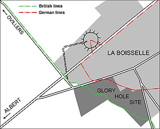
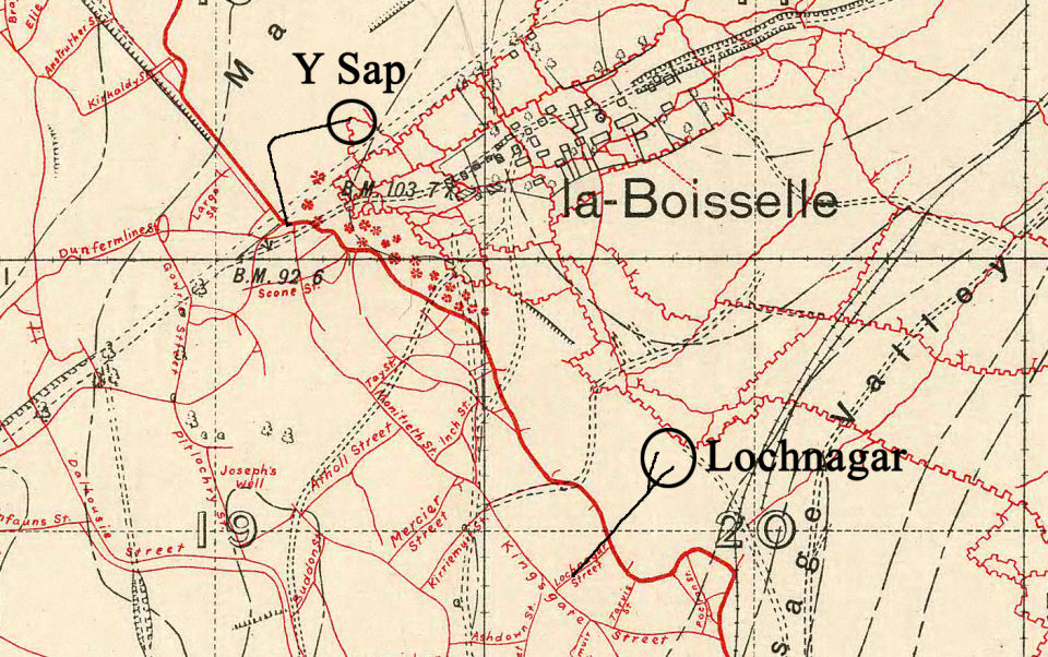
In the British front sector allocated to III Corps at La Boisselle, four mines were prepared: Two charges (known as No 2 straight and No 5 right) were planted at L'îlot at the end of galleries dug from Inch Street Trench by the 179th Tunnelling Company, intended to wreck German tunnels[19] and create crater lips to block enfilade fire along no man's land. As the Germans in La Boisselle had fortified the cellars of ruined houses, and cratered ground made a direct infantry assault on the village impossible, two further mines, known as Y Sap and Lochnagar after the trenches from which they were dug, were laid on the north-east and the south-east of La Boisselle to assist the attack on either side of the German salient in the village[9][7] – see map.
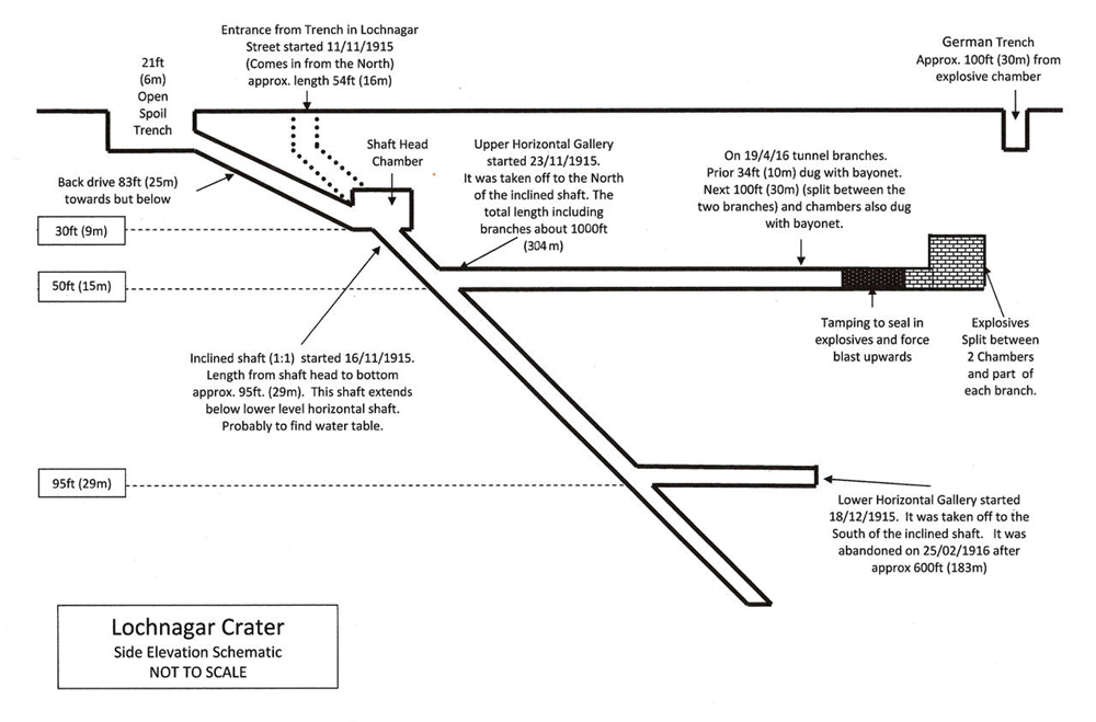
Map of the Lochnagar mine; for an aerial view of the site with marked front lines, see here
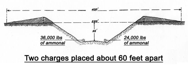
The 185th Tunnelling Company started work on the Lochnagar mine on 11 November 1915 and handed the tunnels over to 179th Tunnelling Company in March 1916.[7] A month before the handover, 18 men of the 185th Tunnelling Company (2 officers, 16 sappers) were killed on 4 February when the Germans detonated a camouflet near the British three-level mine system, starting from Inch Street, La Boisselle, the deepest level being just above the water table at around 30 metres (100ft).[7] The Lochnagar mine consisted of two chambers with a shared access tunnel (see map). The shaft was sunk in the communication trench called Lochnagar Street. After the Black Watch had arrived at La Boissselle at the end of July 1915, many existing Allied fortifications, originally dug by the French, had been given Scotland-related names. The Lochnagar mine probably had the first deep incline shaft, which sloped 1:2–1:3 to a depth of about 29 metres (95ft) – see map. It was begun 91 metres (300ft) behind the British front line and 270 metres (900ft) away from the German front line. Starting from the inclined shaft, about 15 metres (50ft) below ground, a gallery was driven towards the German lines.[7] For silence, the tunnellers used bayonets with spliced handles and worked barefoot on a floor covered with sandbags. Flints were carefully prised out of the chalk and laid on the floor; if the bayonet was manipulated two-handed, an assistant caught the dislodged material. Spoil was placed in sandbags and passed hand-by-hand, along a row of miners sitting on the floor and stored along the side of the tunnel, later to be used to tamp the charge.[20] When about 41 metres (135ft) from the Schwabenhöhe, the tunnel was forked into two branches and the end of each branch was enlarged to form a chamber for the explosives, the chambers being about 18 metres (60ft) apart and 16 metres (52ft) deep[7] – see map. When finished, the access tunnel for the Lochnagar mine was 1.37 by 0.76 metres (4.5ft ×2.5ft) and had been excavated at a rate of about 46 centimetres (18in) per day, until about 310 metres (1,030ft) long, with the galleries beneath the Schwabenhöhe. The mine was loaded with 27,000 kilograms (60,000lb) of ammonal, divided in two charges of 16,000 kilograms (36,000lb) and 11,000 kilograms (24,000lb).[20] As the chambers were not big enough to hold all the explosive, the tunnels that branched to form the 'Y' were also filled with ammonal. The longer branch was 18 metres (60ft) long, the shorter was 12 metres (40ft) long. The tunnels did not quite reach the German front line but the blast would dislodge enough material to form a 4.6 metres (15ft) high rim and bury nearby trenches.[7]
Plan of the Y Sap mine. The Glory Hole site was known as Granathof to the Germans and as L'îlot de La Boisselle to the French.
The tunnel for the Y Sap mine underneath the German trenches overlooking Mash Valley[21] just north of La Boisselle started in the British front line near where it crossed the D 929 Albert–Bapaume road, but because of German underground defences it could not be dug in a straight line. About 460 metres (500yd) were dug into no man's land, before it turned right for about another 460 metres (500yd). About 18,000 kilograms (40,000lb) of ammonal was placed in the chamber beneath the Y Sap mine.[7] The Lochnagar and the Y Sap mines were "overcharged" to ensure that large rims were formed from the disturbed ground.[7] Communication tunnels were also dug for use immediately after the first attack but were little used in the end.[7] The mines were laid without interference by German miners but as the explosives were placed, German miners could be heard below Lochnagar and above the Y Sap mine.[20]
In the British front sector allocated to XV Corps at Fricourt, the German positions were extremely strong and the village itself was like a fortress. For this reason, no frontal assault was planned in this area for 1 July[22] as the British infantry would have had to advance across large crater fields.[23] Instead, the tunnellers would place a group of three mines known as Triple Tambour beneath the German Kniewerk stronghold.[24][25] Local but fierce underground fighting at Fricourt had taken place in the winter of 1914 and spring of 1915,[3] during which the Tambour had been extensively mined.[26] The French had carried out mining operations in the Tambour area when they held this sector of the line and British tunnellers began working there on mines in August 1915.[27] The whole area was a veritable warren of shafts and tunnels which had produced a patchwork of small craters,[28] German trench maps indicating five craters before 1 July 1916.[26] The three Tambour mines were laid by 178th Tunnelling Company.[29] The craters resulting from the explosion of the charges were intended to protect the infantry advance of the 21st Division from German enfilade fire from the village of Fricourt. It was thought the mines could raise a protective "lip" of earth that would obscure the view from the village and the German machine-gun positions but the effort failed.[30][26] The three Tambour mines were loaded with relatively small charges of 4,100 kilograms (9,000lb), 6,800 kilograms (15,000lb) and 11,000 kilograms (25,000lb) which were detonated at 7:28a.m., just before the British infantry advanced; one failed to explode due to damp and is reportedly still buried off Fricourt.[31] 178th Tunnelling Company's war diary entry reads "1/7/16 "Z"Day. Mines in G3E, G19A exploded at 7:28 a.m. 2 minutes before Zero. G15b not successful".[32] According to an account of the British attack on Fricourt "...A British attack west of the Tambour was countered by a defensive mine, which inflicted many casualties on the 21st Division as it attacked, along with machine-gun fire from the hill above Fricourt."[33][c] The site of the mines appears as a small area of cratered ground in the field beyond the Commonwealth War Graves Commission Fricourt New Military Cemetery.[35][31] The land the craters are on is private property.[27] The two craters on the eastern edge of the craterfield are probably the G3 and G19 mines.[26]
In the front sector allocated to XV Corps between Fricourt and Mametz,[36] the Mametz West group of four 230-kilogram (500lb) mines was planted along the German trench lines running east from the heights of Bois Français, located south of Hidden Wood[37] and 1.03 kilometres (0.64mi) south-east of Fricourt.[28] The unit in charge was the 174th Tunnelling Company.[38] Underground fighting at Bois Français had already taken place in the winter of 1914 and spring of 1915.[3] Before the summer of 1916, no-man's land south of Bois Français had already witnessed the blowing of at least eight mines, and the area of Kiel and Danube trenches, located some 0.46 kilometres (500yd) to the east of Bois Français, had also seen extensive underground operations.[28] In October 1915, John Norton-Griffiths had even advocated the use of poison gas to deal with the German resistance in the Bois Français sector, but the proposal was not followed up. As at Fricourt, no frontal assault was planned in this area for 1 July as the British infantry would have had to advance across large crater fields.[23] Instead, the Royal Engineers placed the Mametz West mine group there – three charges at Kiel Trench and one at Danube Trench. The first purpose of these mines was to protect the left of the 7th Division's attack south of Mametz, while the second was to protect the 20th Battalion, Manchester Regiment during their attack on the German lines.[28]
The Mametz East group consisted of four mines in the Mametz sector, all laid by 183rd Tunnelling Company.[23] Bulgar Point, a heavily wired[36] German strong work[22] facing the 1st Battalion South Staffordshire Regiment's attack south-east of Mametz, was mined with 910 kilograms (2,000lb) of explosives;[37] a sap further west was loaded with a 91-kilogram (200lb) charge[37] in support of the Gordon Highlanders' attack;[28] and two more 230-kilogram (500lb) mines were laid beneath Austrian Trench, on the extreme right of the 7th Division's sphere of action, on the boundary with the front sector allocated to XIII Corps.[28] In addition to placing the four mines, 183rd Tunnelling Company from February 1916 onwards prepared dozens of Russian saps for the attack, which ran from the British front line to the very edge of the German positions. Small charges could be blown from the end of these tunnels and they could then be used to reinforce the captured positions.[23] Four saps were further equipped with Livens Large Gallery Flame Projectors, ready to cover the German front line with liquid fire. In order to protect them from enemy fire, the flame throwers were hauled into the saps just hours before the battle. Two tunnels which housed such weapons – located at Kiel Trench south-west of Mametz and between Carnoy and Kasino Point – were damaged by German shellfire before the attack. The two remaining were put to use from saps immediately left of the mine crater field at Carnoy.[39] In view of the work required, 183rd Tunnelling Company took a calculated risk by stopping its defensive mining activities between Carnoy and Fricourt, which had so far guaranteed the underground safety of the British trenches in that area.[40] By 1 July, the British tunnel network excavated in this sector extended 91 metres (300ft) under no man's land.
Early underground fighting at Carnoy had taken place in the winter of 1914 and spring of 1915.[3] Mine warfare directly in front of Carnoy, near the Carnoy–Montauban road, was conducted by both sides from May 1916.[41] In this southernmost sector of the British front line, which was allocated to XIII Corps, three mines were laid by 183rd Tunnelling Company. Two were to be fired north of Carnoy at 07.27 hours:[36] a 2,300-kilogram (5,000lb) charge under a German salient at Kasino Point and a 230-kilogram (500lb) charge on the extreme left flank, intended to collapse German dug outs and destroy machine-gun nests.[42] The third mine in the Carnoy group also held a 230-kilogram (500lb) charge. As in the Mametz East sector, 183rd Tunnelling Company had to stop its defensive mining activities off Carnoy so the work underground could be finished in time. All deep mining was halted, except at Kasino Point where an inclined gallery was built. As the chalk grew harder, the method of softening involved drilling holes with a carpenter's auger, into which the miners poured vinegar. When it was fired, the mine produced a crater with lips 30 metres (97ft) in diameter and 9.1 metres (30ft) deep. The miners reported after the attack that the Kasino Point mine had buried three German dugouts and four sniper's posts, and probably a machine-gun emplacement as well.[40] During tunnelling at Kasino Point, the British broke into a German dugout but were able to cover it up before the breach was noticed.[41]J. E. Edmonds wrote in 1932 that this incident occurred during the digging of Russian saps rather than the Kasino Point mine.[43] Middlebrook wrote in 1971 that the Kasino Point Salient was between Mametz, Carnoy and Montauban and the mine planted there was one of seven large mines that were due to be detonated on 1 July.[44]
The mines were detonated by the Royal Engineers in the morning of Saturday 1 July, the opening day of the Battle of Albert(1–13 July), the name given by the British to the first two weeks of the Battle of the Somme. The British Third and Fourth armies, together with nine corps of the French Sixth Army, would attack the German 2nd Army in an area stretching from Foucaucourt south of the River Somme northwards beyond the River Ancre, to Serre and Gommecourt, 3.2 kilometres (2mi) beyond. The objective of the attack was to capture the German first and second positions from Serre south to the D 929 Albert–Bapaume road and the first position from the road south to Foucaucourt.
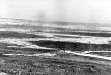
The crater left by the mine fired beneath Hawthorn Ridge Redoubt (IWM Q 1527, November 1916); note shadow of photographer, left foreground
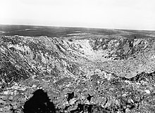
British aerial photograph showing the Lochnagar Crater and trenches
Troops passing the Lochnagar Crater, October 1916
Lochnagar crater in 2017.
The Hawthorn Ridge mine was detonated at 7:20 a.m.. The explosion was filmed by British cinematographerGeoffrey Malins who had his camera set up about 0.80-kilometre (0.5mi) away.[45] A frame from the film became one of the iconic photographs of the first day of the battle.[46] As soon as the mine blew, the British heavy artillery bombardment on the German front line lifted and Stokes mortars began a hurricane bombardment on the front trench. British troops rushed the crater where they were engaged by machine-gun and rifle fire from the far lip and the flanks. Three sections of German infantry (about thirty men) of the 9th Company were killed in the mine explosion and 1+1⁄2 platoons were trapped in their Unterstände (underground shelters), from which only two sections escaped. The rest of the company in a Stollen (deep-mined dugout) survived but the entrances were blocked and the troops inside were not rescued until after the British attack.[47] Despite the shock and disorientation caused by the detonation of the mine, German troops immediately occupied the rear lip of the crater. The Germans also immediately brought down a heavy artillery barrage onto the British trenches. The 2nd Battalion, Royal Fusiliers (86th Brigade, 29th Division), crossing no man's land to occupy the crater, came under heavy German rifle and machine-gun fire from either flank and the rear lip. A few British soldiers managed to reach the closest lip of the crater and held on until noon when they were forced out by a German counter-attack. The failure to take the Hawthorn Ridge Redoubt had a serious effect on the VIII Corps operations north of the River Ancre.[48]
Eight minutes after the explosion of the Hawthorn Ridge mine, the Lochnagar mine was detonated at 7:28 a.m., along with the other mines prepared for the First day of the Somme. The explosion of the Lochnagar mine was initiated by Captain James Young of the 179th Tunnelling Company, who pressed the switches and observed that the firing had been successful.[7] The two charges of the Lochnagar mine obliterated 91–122 metres (300–400ft) of German fortifications,[49] including nine dugouts and the men inside them. Earth was thrown 1,200 metres (4,000ft) into the air.[21] Most of the 5th Company of Reserve Infantry Regiment 110 and the trenches nearby were destroyed.[49] The Lochnagar mine lay on the sector assaulted by the Grimsby Chums, a Pals battalion (10th Battalion, The Lincolnshire Regiment).[50] When the main attack began at 7:30 a.m., the Grimsby Chums occupied the crater and began to fortify the eastern lip, which dominated the vicinity and the advance continued to the Grüne Stellung (second position), where it was stopped by the German 4th Company, which then counter-attacked and forced the British back to the crater.[49]
At Bulgar Point, located east of Mametz in the front sector allocated to XV Corps, the German position was completely destroyed by the detonation of the No 12 mine with 910 kilograms (2,000lb) of ammonal. Four other British mines in the already cratered area between Mametz and Fricourt also exploded successfully.[22]
Though the mines on the British front were to be blown at 7:28 a.m. (the only exception being that at Hawthorn Ridge), the Kasino Point mine was late, because the officer in charge hesitated when he saw that British troops had left their trenches and begun to advance across no man's land. The German machine-gunners at the point opened fire and inflicted many casualties, so the officer detonated the mine which, instead of exploding upwards, sent debris outwards over wide area, causing casualties among at least four British battalions, as well as obliterating several German machine-gun nests. A witness wrote later
I looked left to see if my men were keeping a straight line. I saw a sight I shall never forget. A giant fountain, rising from our line of men, about 100 yards from me. Still on the move I stared at this, not realizing what it was. It rose, a great column nearly as high as Nelson's Column, then slowly toppled over. Before I could think, I saw huge slabs of earth and chalk thudding down, some with flames attached, onto the troops as they advanced.
but the late detonation surprised and demoralised the Germans, whose fire diminished and the British swept over the German front trenches, making it the most successful mine detonation of 1 July.[52] Looking back at building the Lochnagar mine, Captain Stanley Bullock of 179th Tunnelling Company described the conditions of the work,
At one place in particular our men swore they thought he [the German enemy] was coming through, so we stopped driving forward and commenced to chamber in double shifts. We did not expect to complete it before he blew, but we did. A chamber 12′ × 6′ × 6′ in 24 hours. The Germans worked for a shift more than we did and then stopped. They knew we had chambered and were afraid we should blow and no more work was done there. I used to hate going to listen in that chamber more than any other place in the mine. Half an hour, sometimes once sometimes three times a day, in deadly silence with the geophone to your ears, wondering whether the sound you heard was the Boche working silently or your own heart beating. God knows how we kept our nerves and judgement. After the Somme attack when we surveyed the German mines and connected up to our own system, with the theodolite we found that we were 5 feet apart, and that he had only started his chamber and then stopped.
While the British mines on the first day of the Somme were an undoubted success for the tunnellers who had built and maintained them, their value for the advancing infantry was questioned:
The nineteen mine craters, in which so many soldiers were trapped and killed by the German machine-gunners, became a hated feature of the battlefield.
The blowing of the Lochnagar and Y Sap mines at 7:28a.m. was witnessed by pilots who were flying over the battlefield to report back on British troop movements. It had been arranged that continuous overlapping patrols would fly throughout the day. 2nd LieutenantCecil Lewis' patrol of 3 Squadron was warned against flying too close to La Boisselle, where two mines were due to go up, but would be able to watch from a safe distance. Flying up and down the line in a Morane Parasol, he watched from above Thiepval, almost two miles from La Boisselle, and later described the early morning scene in his book Sagittarius Rising (1936),
We were over Thiepval and turned south to watch the mines. As we sailed down above all, came the final moment. Zero! At Boisselle the earth heaved and flashed, a tremendous and magnificent column rose up into the sky. There was an ear-splitting roar, drowning all the guns, flinging the machine sideways in the repercussing air. The earthly column rose, higher and higher to almost four thousand feet. There it hung, or seemed to hang, for a moment in the air, like a silhouette of some great cypress tree, then fell away in a widening cone of dust and debris. A moment later came the second mine. Again the roar, the upflung machine, the strange gaunt silhouette invading the sky. Then the dust cleared and we saw the two white eyes of the craters. The barrage had lifted to the second-line trenches, the infantry were over the top, the attack had begun.
—Cecil Lewis, whose aircraft was hit by lumps of mud thrown up by the explosion.[54][55]
Aftermath
In 1932, Brigadier Sir James Edmonds wrote regarding the mines that the "lack of manpower prevented more [from] being undertaken". Sir Martin Gilbert wrote in 2007 that although fewer mines than planned had been completed, "it was a formidable enterprise".
Following the attack on 1 July, there were a few other mines blown during the Battle of the Somme. In the south of the battlefield, the front line moved on from the mine systems.[56] In other areas, where the British had not gained much ground, schemes for new Russian saps were put in place by 3 July and the miners' sapping efforts intensified with the aim of quadrupling the number of Russian saps for future attacks.
At High Wood, the 178th Tunnelling Company drove a mine at just 7.6 metres (25ft) depth, 98 metres (320ft) long, which they charged with 1,400 kilograms (3,000lb) of ammonal. It was blown thirty seconds before Zero Hour on 3 September 1916. After advancing British infantry had failed to capture the crater permanently, 178th Tunnelling Company reopened the gallery, charged it with another 1,400 kilograms (3,000lb) of ammonal and blew the mine again on 9 September. This time the crater was successfully held.[56]
In the north of the battlefield, after the detonation of the H3 mine at Hawthorn Ridge Redoubt on 1 July, 252nd Tunnelling Company on 4 July began work on a second mine, loaded with 14,000 kilograms (30,000lb) of ammonal, which was placed beneath the crater of the first explosion. This new mine was fired to signal Zero Hour at the start of the Battle of the Ancre on 13 November,[56] when a successful British attack took the village of Beaumont-Hamel. The crater visible on Hawthorn Ridge is therefore actually a double crater, lined today with trees and thick undergrowth, but not filled with water. The site affords good views of the location of the German positions.[57]
During the Allied preparations for the Battle of Vimy Ridge (9 – 12 April 1917) the mines fired on the first day of the Somme became the object of strategic considerations. In order to assess the consequences of infantry having to advance across cratered ground after a mining attack, officers from the Canadian Corps visited La Boisselle and Fricourt where the mines had been blown. Their reports and the experience of the Canadians at St Eloi in April 1916 – where mines had so altered and damaged the landscape as to render occupation of the mine craters by the infantry all but impossible –, led to the decision to remove offensive mining from the central sector allocated to the Canadian Corps at Vimy Ridge.[58]
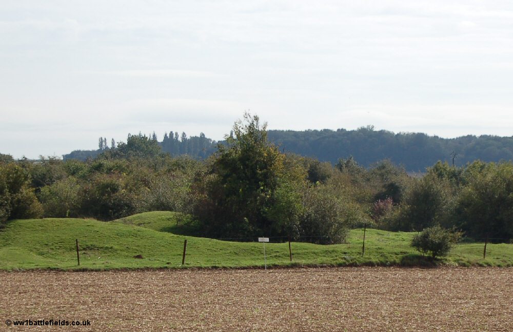
The Lochnagar Crater in 2005
William Orpen, an official war artist, saw the Lochnagar mine crater in 1916 while touring the Somme battlefield, collecting subjects for paintings and described a wilderness of chalk dotted with shrapnel. John Masefield also toured the Somme, while preparing The Old Front Line (1917), in which he also described the area around the Lochnagar Crater as dazzlingly white and painful to look at.[59]
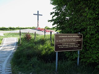
The land around the Lochnagar Crater was eventually purchased by an Englishman, Richard Dunning, to ensure its preservation after he read The Old Front Line and was inspired to buy a section of the former front line.[60] The site attracts about 200,000 visitors a year and there is an annual memorial service on 1 July, to commemorate the detonation of the mine and the British, French and German war dead.[50][61]
↑ See also The real hero tunnellers of World War One who inspired BBC's Birdsong, www.mirror.co.uk, 21 January 2012 (online), access date 6 July 2015, where the date of the detonation is given with 22 October 1915.
↑ The plan was quashed at British Expeditionary Force General Headquarters (GHQ) after the Inspector of Mines pointed out that the British had never managed to reach a mine crater before the Germans and that the mine should be detonated at zero hour.[17]
↑ James Edmonds, the British official historian, wrote that there was no British account of a mine or an explosion killing 80 British soldiers.[34]
↑ Heather Hill, Oliver Frank Field, 178th Tunnelling Company, in: Buckets & Spades (Weston-super-Mare & District Family History Society) June 2014, onlineArchived 21 December 2016 at the Wayback Machine
The first day on the Somme was the beginning of the Battle of Albert (1–13 July) the name given by the British to the first two weeks of the Battle of the Somme in the First World War. Nine corps of the French Sixth Army and the British Fourth and Third armies attacked the German 2nd Army. The attack was from Foucaucourt south of the Somme, northwards across the Somme and the Ancre to Serre and Gommecourt, 2 mi (3.2 km) beyond, in the Third Army area. The objective of the attack was to capture the German first and second defensive positions from Serre south to the Albert–Bapaume road and the first position from the road south to Foucaucourt.
Ovillers-la-Boisselle is a commune in the Somme department in Hauts-de-France in northern France.
Hawthorn Ridge Redoubt was a German field fortification, west of the village of Beaumont Hamel on the Somme. The redoubt was built after the end of the Battle of Albert and as French and later British attacks on the Western Front became more formidable, the Germans added fortifications and trench positions near the original lines around Hawthorn Ridge. At 7:20 a.m. on 1 July 1916, the British fired a huge mine beneath the Hawthorn Ridge Redoubt. Sprung ten minutes before zero hour, the mine was one of 19 mines detonated on the first day of the Battle of the Somme. Geoffrey Malins, one of two official war cameramen, filmed the detonation of the mine. The attack on the redoubt by part of the 29th Division of VIII Corps was a costly failure.
The Lochnagar mine south of the village of La Boisselle in the Somme département was an underground explosive charge, secretly planted by the British during the First World War, to be ready for 1 July 1916, the first day on the Somme. The mine was dug by the Tunnelling Companies of the Royal Engineers under a German field fortification known as Schwabenhöhe. A large crater survived the war known as the Lochnagar crater or the Trou de mine de La Boisselle.
Royal Engineer tunnelling companies were specialist units of the Corps of Royal Engineers within the British Army formed to dig attacking tunnels under enemy lines during the First World War.
Livens Large Gallery Flame Projectors were large experimental flamethrowers used by the British Army in World War I, named after their inventor, Royal Engineers officer William Howard Livens.
Fricourt is a village that was fought over in July 1916, during the Battle of the Somme, which took place in France during the First World War. Fricourt is 3 mi (4.8 km) from Albert, north of Bray and west of Mametz, near the D 938 road and at the junction of the D 147 with the D 64. The village is 20 mi (32 km) north-east of Amiens and on the route of the Albert–Péronne light railway. Fricourt Wood was north-east of the village, with a château on the edge of the village and a number of craters, known as the Tambour on the west side. Fricourt formed a salient in the German front-line and was the principal German fortified village between the River Somme and the Ancre.
The Capture of Montauban, took place on 1 July 1916, the first day of the Battle of the Somme, between the British Fourth Army and the French Sixth Army against the German 2nd Army, on the Western Front, during the First World War. Montauban is a commune in the Somme department in Picardy in northern France and lies on the D 64, between Guillemont to the east and Mametz to the west. To the north are Bazentin-le-Petit and Bazentin-le-Grand. Bernafay and Trônes woods are to the north-east and Maricourt lies to the south.
The Capture of Mametz took place on 1 July 1916, when the British Fourth Army attacked the German 2nd Army on the Western Front, during the first day of the Battle of the Somme. Mametz is a village on the D 64 road, about 20 mi (32 km) north-east of Amiens and 4 mi (6.4 km) east of Albert. Fricourt lies to the west, Contalmaison is to the north, Montauban to the north-east and Carnoy and Maricourt are to the south-east. Mametz Wood is 1,000 yd (910 m) to the north-west and before 1914, the village was the fifth largest in the area, with about 120 houses and had a station on the line from Albert to Péronne. During the Battle of Albert the II Bavarian Corps attacked westwards north of the Somme but was fought to a standstill east of Mametz. Reinforced by the XIV Reserve Corps the Germans on the north side of the Somme attacked again and took Mametz on 29 September. After a mutually costly battle for Fricourt, where the French were eventually forced out, the front line stabilised and both sides began to improvise defences. In mid-December a French local attack in the Mametz area was a costly failure.
The Capture of La Boisselle was a tactical incident during the Battle of Albert, the name given by the British to the first two weeks of the Battle of the Somme. The village of La Boisselle forms part of the small commune of Ovillers-la-Boisselle about 22 mi (35 km) north-east of Amiens in the Somme department in Picardie in northern France. To the north-east of La Boisselle lies Ovillers; by 1916, the village was called Ovillers by the British Expeditionary Force (BEF) to avoid confusion with La Boisselle, south of the road.
The 172nd Tunnelling Company was one of the tunnelling companies of the Royal Engineers created by the British Army during World War I. The tunnelling units were occupied in offensive and defensive mining involving the placing and maintaining of mines under enemy lines, as well as other underground work such as the construction of deep dugouts for troop accommodation, the digging of subways, saps, cable trenches and underground chambers for signals and medical services.
The 174th Tunnelling Company was one of the tunnelling companies of the Royal Engineers created by the British Army during World War I. The tunnelling units were occupied in offensive and defensive mining involving the placing and maintaining of mines under enemy lines, as well as other underground work such as the construction of deep dugouts for troop accommodation, the digging of subways, saps, cable trenches and underground chambers for signals and medical services.
The 178th Tunnelling Company was one of the tunnelling companies of the Royal Engineers created by the British Army during World War I. The tunnelling units were occupied in offensive and defensive mining involving the placing and maintaining of mines under enemy lines, as well as other underground work such as the construction of deep dugouts for troop accommodation, the digging of subways, saps, cable trenches and underground chambers for signals and medical services.
The 179th Tunnelling Company was one of the tunnelling companies of the Royal Engineers created by the British Army during World War I. The tunnelling units were occupied in offensive and defensive mining involving the placing and maintaining of mines under enemy lines, as well as other underground work such as the construction of deep dugouts for troop accommodation, the digging of subways, saps, cable trenches and underground chambers for signals and medical services. 179th Tunnelling Company is particularly known for its role at L'îlot de La Boisselle and for firing the Lochnagar mine during the Battle of the Somme 1916. The Lochnagar mine formed part of a series of 19 mines that were placed beneath the German lines on the British section of the Somme front to assist the start of the battle.
The 183rd Tunnelling Company was one of the tunnelling companies of the Royal Engineers created by the British Army during World War I. The tunnelling units were occupied in offensive and defensive mining involving the placing and maintaining of mines under enemy lines, as well as other underground work such as the construction of deep dugouts for troop accommodation, the digging of subways, saps, cable trenches and underground chambers for signals and medical services.
The 185th Tunnelling Company was one of the tunnelling companies of the Royal Engineers created by the British Army during World War I. The tunnelling units were occupied in offensive and defensive mining involving the placing and maintaining of mines under enemy lines, as well as other underground work such as the construction of deep dugouts for troop accommodation, the digging of subways, saps, cable trenches and underground chambers for signals and medical services.
The 252nd Tunnelling Company was one of the tunnelling companies of the Royal Engineers created by the British Army during World War I. The tunnelling units were occupied in offensive and defensive mining involving the placing and maintaining of mines under enemy lines, as well as other underground work such as the construction of deep dugouts for troop accommodation, the digging of subways, saps, cable trenches and underground chambers for signals and medical services. 252nd Tunnelling Company is particularly known for creating the Hawthorn Ridge mine during the Battle of the Somme 1916, which formed part of a series of mines that were placed beneath the German lines.
L'îlot de La Boisselle is a small, 3.12-hectare (7.7-acre) historic site in the commune of Ovillers-la-Boisselle in the Somme department in Picardie in northern France. L'îlot was heavily fought over during the First World War, when it was known as Granathof to the Germans and as Glory Hole to British soldiers. The site is private property and opens to the public by appointment with Claudie Llewellyn.
In World War I, the small commune of Ovillers-la-Boisselle, located some 22 miles (35 km) north-east of Amiens in the Somme department in Hauts-de-France in northern France, was the site of intense and sustained fighting between German and Allied forces. Between 1914 and 1916, the Western Front ran through the commune, and the villages were completely destroyed. After the Armistice of 11 November 1918, the former inhabitants returned and gradually rebuilt most of the infrastructure as it had been before the war.
The Y Sap mine was an underground explosive charge, secretly planted by the British during the First World War and ready for 1 July 1916, the first day on the Somme. The mine was dug by the Tunnelling Companies of the Royal Engineers under a German machine-gun nest known as Blinddarm (appendix) in the front line, on the north side of the village of La Boisselle in the Somme département. The mine was named after Y Sap, the British trench from which the gallery was driven. It was one of 19 mines on the British sector to be blown at the start of the battle.
References
Books
Barrie, A. (1981) [1962]. War Underground. War in the Twentieth Century (Stared.). London: Frederick Muller. ISBN978-0-352-30970-9.
Bülow, K von; Kranz, W.; Sonne, E.; Burre, O.; Dienemann, W. (1943) [1938]. Wehrgeologie (Engineer Research Office, New Yorked.). Leipzig: Quelle & Meyer. OCLC44818243.
Edmonds, J. E. (1993) [1932]. Military Operations France and Belgium, 1916: Sir Douglas Haig's Command to the 1st July: Battle of the Somme. History of the Great War Based on Official Documents by Direction of the Historical Section of the Committee of Imperial Defence. Vol.I (Imperial War Museum and Battery Pressed.). London: Macmillan. ISBN978-0-89839-185-5.
Grieve, W. Grant; Newman, Bernard (2001) [1936]. Tunnellers: A History of the Tunnelling Companies, Royal Engineers, During the Great War. Uckfield: Naval & Military Press. ISBN978-1-84342-083-5.
Gliddon, G. (1987). When the Barrage Lifts: A Topographical History and Commentary on the Battle of the Somme 1916. Norwich: Gliddon Books. ISBN0-947893-02-4.
Holt, Tonie; Holt, Valmai (2008). Major & Mrs Holt's Battlefield Guide to the Somme. Barnsley: Pen & Sword Books. ISBN978-0-85052-414-7.
Kuhl, Hermann von (1929). Der Weltkrieg, 1914–1918: dem deutschen Volke dargestellt (in German). Berlin: Verlag Tradition W. Kolk. OCLC695752254.
Lewis, C. A. (1977) [1936]. Sagittarius Rising: The Classic Account of Flying in the First World War (2nd Penguined.). London: Peter Davis. ISBN0-14-00-4367-5. OCLC473683742.
Whitehead, R. J. (2013) [2010]. The Other Side of the Wire: The Battle of the Somme. With the German XIV Reserve Corps, September 1914 – June 1916. Vol.I (paperback reprinted.). Solihull: Helion. ISBN978-1-908916-89-1.
Whitehead, R. J. (2013). The Other Side of the Wire: The Battle of the Somme. With the German XIV Reserve Corps, 1 July 1916. Vol.II. Solihull: Helion. ISBN978-1-907677-12-0.
Wyrall, E. (2009) [1932]. The Nineteenth Division 1914–1918 (Naval & Military Pressed.). London: Edward Arnold. ISBN978-1-84342-208-2.
Hill, H. (2014), "Oliver Frank Field, 178th Tunnelling Company", in: Buckets & Spades (Weston-super-Mare & District Family History Society) June 2014, online
Goodbody, A. (2016), "Mining the Somme", in: Mining Magazine, 18 July 2016, London: Aspermont Media 2016 (online)
Websites
Banning, J. (2011). "Tunnellers". La Boisselle Study Group. et al. Retrieved 26 June 2015.
Dunning, R. (2015). "Military Mining". Lochnagar Crater. Archived from the original on 27 June 2015. Retrieved 26 June 2015.
This page is based on this Wikipedia article Text is available under the CC BY-SA 4.0 license; additional terms may apply. Images, videos and audio are available under their respective licenses.


