
The West Newton Village Center Historic District encompasses the heart of the village of West Newton, in the city of Newton, Massachusetts in the United States. It extends along Washington Street between Lucas Court in the west and Davis Court in the east, and includes a few properties on immediately adjacent side streets, including Watertown Street and Waltham Street. The village is the second-largest of Newton's commercial centers and is the best-preserved of its late 19th and early 20th century village centers. The district was listed on the National Register of Historic Places in 1990.

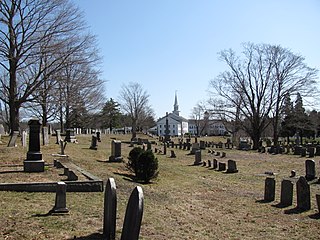
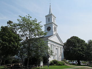
The Old Douglas Center Historic District encompasses the historic heart of Douglas, Massachusetts. The historic district radiates away from the town common, and is bounded by farmlands and more recent 20th-century development. There are 50 contributing resources in the 192-acre (78 ha) district. Most of the structures are residential houses in Federal and Greek Revival styles. There are a number of institutional buildings, including the 1834 Greek Revival First Congregational Church, the Craftsman-style Douglas Pastime Club building at 22 Church Street, and the c. 1770s Dudley Tavern. The town common and the adjacent Center Cemetery, laid out when the town was incorporated in 1746, are at the center of the district.

The Lower Highlands Historic District encompasses one of the oldest residential areas of Fall River, Massachusetts. The district is roughly bounded by Cherry, Main, Winter, and Bank Streets, and is located just east of the Downtown Fall River Historic District and directly south of the Highlands Historic District. This area was settled by 1810, has architecture tracing the city's growth as a major industrial center. The historic district was added to the National Register of Historic Places in 1984.
The Hanover Center Historic District encompasses the historic town center of Hanover, Massachusetts. Established in 1721, the town center includes the town hall, library, and church, as well as its first cemetery and the c. 1700 Stetson House, one of its oldest buildings. The district was listed on the National Register of Historic Places in 1996.

The North Village Historic District encompasses a well-preserved 19th-century rural village on North Main Street in Lancaster, Massachusetts. The district includes a collection of houses, most dating to the first half of the 19th century or earlier. The district was added to the National Register of Historic Places in 1977.

The Sharon Historic District is a historic district on both sides of N. Main Street from Post Office Square to School Street in Sharon, Massachusetts. The area includes the earliest formally laid out part of Sharon, when it was established as a parish of Stoughton in 1740. The district was listed on the National Register of Historic Places in 1975.
The Centerville Historic District is a historic district encompassing the heart of the village of Centerville in Barnstable, Massachusetts. The district extends along Main Street from a point north of its junction with Old Stage Road and Park Avenue, south to the junction with Church Hill Road. Most of the buildings in the district were built in the middle decades of the 19th century, although its oldest building, the Austin Bearse House, was built c. 1690. The area's growth was spurred by the relocation in 1826 of the Congregational Church building to its present location. The district was listed on the National Register of Historic Places in 1987.

The Old King's Highway Historic District encompasses what was historically the principal east–west thoroughfare through Barnstable, Massachusetts. It encompasses Barnstable's entire length of what is now designated Massachusetts Route 6A and called Main Street, between the town lines of Sandwich and Yarmouth. It includes more than 1,000 acres (400 ha), and includes all of the buildings whose properties front on the road, nearly 500 in all. The area includes the main population centers of Barnstable from its founding in the late 1630s until the mid-19th century, when the southern parts of the community became more significant in economic prominence. The district was listed on the National Register of Historic Places in 1987.

The Pleasant–School Street Historic District is a predominantly residential historic district in the Hyannis village of Barnstable, Massachusetts. It includes 37 properties on Pleasant and School Streets, between Main and South Streets, near the center of Hyannis. Pleasant Street was laid out in the 18th century, and School Street was laid out c. 1850, and is distinctive for its cohesive collection of Greek Revival cottages, most of which were owned by mariners active in the coasting trade. The district was listed on the National Register of Historic Places in 1987.

The South Yarmouth/Bass River Historic District is a historic district in the southeastern part of Yarmouth, Massachusetts. It encompasses a predominantly residential area centered on a portion of Old Main Street and South Street between the villages of South Yarmouth and Bass River. The area's history is one of maritime-related industry from the late 18th to late 19th century, and then its growth as a tourist resort community. The district was listed on the National Register of Historic Places in 1990.

The Belchertown Center Historic District is a historic district which encompasses the historic village center of Belchertown, Massachusetts. Centered on Belchertown's 1,200-foot (370 m) common, the district includes 55 contributing properties along South Main Street, Maple Street, and a few adjacent streets. It was listed on the National Register of Historic Places in 1982.

The East Village Historic District is a historic district encompassing the center of the East Village of Amherst, Massachusetts. It includes properties on Main Street, North East Street, and South East Street. The village was one of Amherst's principal civic and commercial centers until the arrival of the railroad in Amherst Center in 1853, and remained a primarily residential area thereafter. The district was listed on the National Register of Historic Places in 1986.

The Central Street District is a historic district encompassing the traditional heart of Andover, Massachusetts prior to the development in the later 19th century of the current town center. It consists mainly of residential and religious properties along Central Street, from Phillips Street in the south to Essex Street in the north. All of the listed properties have frontage on Central Street, even if their addresses are on one of the adjacent streets.
The Diamond Historic District is a seaside, 69.5-acre (28.1 ha) National Register historic district in Lynn, Massachusetts. Established by the National Park Service in 1996, the district is situated between downtown Lynn and the Atlantic Ocean--bounded roughly by Broad and Lewis Streets to the north, Lynn Shore Drive to the southeast, Nahant Street to the west, and Eastern Avenue to the east. The Diamond Historic District encompasses 590 contributing resources.
The Main Street Historic District in Haverhill, Massachusetts represents the civic core of Haverhill and a gateway to the city's Highlands neighborhood and lakes district. Overlooking a mid-20th century urban renewal clearance area northeast of the main business and industrial district of the city, it was listed on the National Register of Historic Places in 2003.

The Church Street Historic District in Wilmington, Massachusetts encompasses the largest cluster of high-style 19th- and early 20th-century homes in the town. The district stretches along Church Street from Hanover Street and Clark Street northeast to the town common, which is part of the Wilmington Centre Village Historic District, and includes one non-contributing house on Central Street. Most of the houses in the district are Queen Anne Victorians built in the 1880s and 1890s; the oldest building is the Maynard Spaulding House at 84 Church Street, an early 1850s house with transitional Greek Revival styling. There are three Italianate houses, and a smattering of 20th century styles, including Colonial Revival and Craftsman houses.
The Woburn Street Historic District of Reading, Massachusetts encompasses a two-block section of late 19th century upper-class housing. The 10-acre (4.0 ha) extends along Woburn Street from Summer Street to Temple Street, and includes sixteen houses on well-proportioned lots along an attractive tree-lined section of the street. The historic district was listed on the National Register of Historic Places in 1985.

The Common Historic District is a historic district encompassing the civic and institutional heart of Reading, Massachusetts. The district is centered on the town common, at the intersection of Main and Salem Streets. The common has been communally owned since at least 1737, with the original burying ground to the north. In 1769 the area's first meeting house was built, giving the area a sense of identity separate from portions of Reading that would later be set off as Wakefield and North Reading. Since then the area has become a focal point for religious and civic institutions in the town.

The Common District encompasses the main civic center of Wakefield, Massachusetts. It is centered on the historic town common, just south of Lake Quannapowitt, which was laid in 1644, when it became the heart of Old Reading. The area was separated from Reading as South Reading in 1818, and renamed Wakefield in 1868. The 25 acre district includes the buildings that line the common on Common Street and Main Street, which include the town hall, public library, YMCA, and several churches. It was listed on the National Register of Historic Places in 1990.

The Head of the River Historic District is a historic district encompassing a village area at the head of navigation of the Acushnet River, which separates Acushnet and New Bedford, Massachusetts. The village is centered at the junction of Tarkin Hill Road, River Road, and Mill Road in New Bedford, and Main Street in Acushnet. The area went through two significant periods of development: the first was in the late 18th and early 19th century, and the second was in the early 20th century. The district was listed on the National Register of Historic Places in 2009.


