Sierra Buttes is an 8,591-foot-elevation (2,619-meter) mountain summit located in the Sierra Nevada mountain range in Sierra County, California, United States. It is the third-highest point in Sierra County following the north ridge of Mount Lola and Peak 8740. Sierra Buttes are set on land managed by Tahoe National Forest and are within the North Yuba River watershed. The summit is situated two miles (3.2 km) north of Sierra City, and approximately 70 miles (110 km) northeast of Sacramento. Topographic relief is significant as the southwest aspect rises nearly 4,700 feet above the Yuba–Donner Scenic Byway in approximately two miles. The prominent fortress-like landform is visible from as far as the Sacramento Valley, and inclusion on the Sierra Peaks Section peakbagging list generates climbing interest. This landform's toponym has been officially adopted by the U.S. Board on Geographic Names, and has been in use since at least 1896 when published by the Sierra Club.

West Vidette is a 12,533-foot-elevation (3,820-meter) mountain summit located three miles west of the crest of the Sierra Nevada mountain range, in the northeast corner of Tulare County in northern California. It is situated in Kings Canyon National Park, 13.5 miles (21.7 km) west-southwest of the community of Independence, and 1.27 miles (2.04 km) west of East Vidette. Topographic relief is significant as the north aspect rises 4,300 feet above Junction Meadow in two miles. The John Muir Trail passes below the north aspect of this remote peak. The first ascent of the summit was made September 19, 1926, by Norman Clyde, who is credited with 130 first ascents, most of which were in the Sierra Nevada.

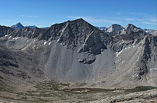
Black Mountain is a 13,291-foot-elevation (4,051-meter) mountain summit located on the crest of the Sierra Nevada mountain range in northern California. It is situated on the common border of Fresno County with Inyo County, as well as the shared boundary of John Muir Wilderness and Kings Canyon National Park. It is 10.5 miles (16.9 km) west of the community of Independence, and 4.3 miles (6.9 km) north-northwest of parent University Peak. Black Mountain ranks as the 91st highest summit in California. Topographic relief is significant as the west aspect rises 2,750 feet above Rae Lakes in approximately one mile. The John Muir Trail traverses below the west aspect of this peak, providing an approach to the mountain. The first ascent of the summit was made in 1905 by George R. Davis, a USGS topographer. This mountain is habitat for the endangered Sierra Nevada bighorn sheep, which restricts climbing from July through December, so most ascents are made in the spring.

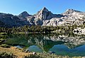
Mount Rixford is a 12,887-foot-elevation (3,928-meter) mountain summit located one mile west of the crest of the Sierra Nevada mountain range, in the southeast corner of Fresno County, in northern California. It is situated in Kings Canyon National Park, 11.5 miles (18.5 km) west of the community of Independence, and one mile north of the Kearsarge Pinnacles and Kearsarge Lakes. Topographic relief is significant as the north aspect rises 2,346 feet above Rae Lakes in one mile. The John Muir Trail crosses Glen Pass one mile to the west of this mountain. Mt. Rixford ranks as the 183rd highest summit in California. Painted Lady is a subsidiary summit at the end of Rixford's north ridge.

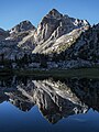
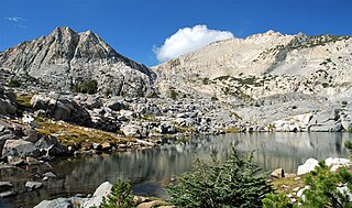
Fin Dome is an 11,673-foot-elevation (3,558-meter) granite summit located 1.5 mile west of the crest of the Sierra Nevada mountain range, in the southeast corner of Fresno County, in northern California. It is situated in the Rae Lakes area of Kings Canyon National Park, approximately 15.5 miles (24.9 km) west of the community of Independence. Nearby peaks include Black Mountain 1.9 miles (3.1 km) to the east, and Mount Rixford 2.1 miles (3.4 km) to the south-southeast. Topographic relief is significant as the east aspect rises 1,135 feet above Rae Lakes in one-quarter mile. The John Muir Trail passes to the east of this landmark, providing an approach. This geographical feature was named by Bolton Brown in 1899 when he explored the lake basin in its vicinity, because it resembled the fin of a sea serpent. The first ascent of the summit was made in 1910 by James Rennie, one of the foremost mountaineers of the Sierra Club.

Mount Bago is an 11,870-foot-elevation (3,620-meter) mountain summit located west of the crest of the Sierra Nevada mountain range, in the southeast corner of Fresno County, in northern California. It is situated in Kings Canyon National Park, 14 miles (23 km) west of the community of Independence, 2.3 miles west of the Kearsarge Pinnacles, and 2.4 miles southwest of Mount Rixford. Topographic relief is significant as the south aspect rises 3,675 feet above Junction Meadow in one mile. The John Muir Trail passes to the northeast of this remote geographical feature. The first ascent of the summit was made July 11, 1896, by Joseph Nisbet LeConte and Wilson S. Gould.
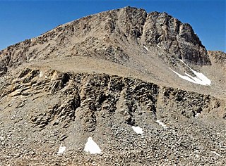
Goodale Mountain is a 12,772-foot-elevation (3,893-meter) mountain summit located one mile east of the crest of the Sierra Nevada mountain range, in Inyo County of northern California. It is situated less than two miles southeast of Taboose Pass in the John Muir Wilderness, on land managed by Inyo National Forest. It is also 16.5 miles (26.6 km) northwest of the community of Independence, and one mile northeast of Striped Mountain, the nearest higher neighbor. Topographic relief is significant as the east aspect rises 7,200 feet above Owens Valley in 3.5 miles. It ranks as the 218th highest peak in California.

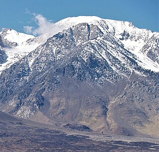
Mount Baldwin is a 12,614-foot-elevation (3,845-meter) mountain summit located in the Sierra Nevada mountain range in Mono County of northern California, United States. It is situated in the John Muir Wilderness on land managed by Inyo National Forest. It is four miles north of Red and White Mountain, and approximately 10.5 miles (16.9 km) southeast of the community of Mammoth Lakes. The nearest higher neighbor is Red Slate Mountain, 2 miles (3.2 km) to the south-southwest. Baldwin ranks as the 257th highest summit in California. Topographic relief is significant as the east aspect rises 3,775 feet above McGee Canyon in 1.5 mile. The first ascent of the summit was made July 2, 1928, by Norman Clyde, who is credited with 130 first ascents, most of which were in the Sierra Nevada.

The Thumb is a 13,356-foot-elevation (4,071-meter) mountain summit located on the crest of the Sierra Nevada mountain range, in Inyo County of northern California. It is situated in the Palisades area of the John Muir Wilderness, on land managed by Inyo National Forest. It is 1.3 miles (2.1 km) east of Middle Palisade, 1.6 miles (2.6 km) west-northwest of Birch Mountain, and 1.8 miles (2.9 km) north of Mount Bolton Brown. The Thumb ranks as the 83rd-highest summit in California. Topographic relief is significant as the east aspect rises over 2,500 feet above Birch Lake in approximately one mile. The John Muir Trail traverses below the southwest aspect of the mountain, providing an optional approach access.
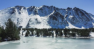
Black Mountain is an 11,797-foot-elevation (3,596 meter) summit located in the Sierra Nevada mountain range, in Mono County of northern California, United States. The mountain is set within the Hoover Wilderness, on the common boundary shared by Inyo National Forest with Humboldt–Toiyabe National Forest, and 1.5 mile outside the boundary of Yosemite National Park. The peak is situated immediately southwest above Virginia Lakes, 1.8 miles (2.9 km) northeast of line parent Excelsior Mountain, and 1.8 miles (2.9 km) south of Dunderberg Peak. Topographic relief is significant as the north aspect rises 1,500 feet above Cooney Lake in one-half mile (0.80 km), and the south aspect rises 3,600 feet above Lundy Canyon in one and a half miles (2.4 km). The first ascent of the summit was made in 1905 by George R. Davis, Albert Hale Sylvester, and Pearson Chapman, all with the United States Geological Survey.

Camiaca Peak is an 11,739-foot-elevation (3,578 meter) mountain summit located on the crest of the Sierra Nevada mountain range in northern California, United States. The peak is situated on the common boundary shared by Yosemite National Park with Hoover Wilderness, as well as the border shared by Mono County with Tuolumne County. It is approximately two miles east of Virginia Peak, three miles west of Dunderberg Peak, and Summit Lake lies at the base of the southeast slope. Topographic relief is significant as the west aspect rises nearly 2,000 feet above Return Creek in three-quarters mile.

Mount Warren is a 12,327-foot-elevation (3,757 meter) summit located in the Sierra Nevada mountain range, in Mono County, California, United States. The mountain is set within the Hoover Wilderness, on land managed by Inyo National Forest. The peak is situated 1.5 miles (2.4 km) south of Gilcrest Peak, 1.8 miles (2.9 km) northwest of Lee Vining Peak, and 5 miles (8.0 km) southeast of Excelsior Mountain, which is the nearest higher neighbor. Topographic relief is significant as the summit rises 5,955 feet above Mono Lake in 4.5 miles.

Mount Stanford is a 12,838-foot-elevation (3,913 meter) mountain summit located on the crest of the Sierra Nevada mountain range in northern California, United States. It is situated in the John Muir Wilderness, on the boundary shared by Sierra National Forest with Inyo National Forest, and along the common border of Fresno County with Mono County. It is 10 miles northeast of Lake Thomas A Edison, and approximately 15 miles (24 km) southeast of the community of Mammoth Lakes. Topographic relief is significant as the north aspect rises 3,200 feet above McGee Creek in approximately 1.75 mile. There is another Mount Stanford in the Sierra Nevada which is named for Stanford University.

Mount Izaak Walton is a 12,077-foot-elevation (3,681 meter) mountain summit located in the Sierra Nevada mountain range in Fresno County of northern California, United States. It is situated in the John Muir Wilderness, on land managed by Sierra National Forest. Mount Izaak Walton ranks as the 404th-highest summit in California. Topographic relief is significant as the northwest aspect rises 1,800 feet above Izaak Walton Lake in approximately one mile. It is six miles northeast of Lake Thomas A Edison, and approximately 14 miles (23 km) south-southeast of the community of Mammoth Lakes. The peak is set on Silver Divide, so precipitation runoff from the north side of this mountain drains into Fish Creek which is a tributary of the San Joaquin River, and from the south slope to Mono Creek, also a tributary of the San Joaquin.
Graveyard Peak is an 11,539-foot-elevation (3,517 meter) mountain summit located in the Sierra Nevada mountain range in Fresno County of northern California, United States. It is situated in the John Muir Wilderness, on land managed by Sierra National Forest. Graveyard Peak ranks as the 535th-highest summit in California, and topographic relief is significant as the south aspect rises over 2,300 feet above Devils Bathtub in approximately one mile. It is two miles southeast of Silver Peak, five miles north of Lake Thomas A Edison, and approximately 13 miles (21 km) south of the community of Mammoth Lakes. The peak is set on Silver Divide, so precipitation runoff from the north side of this mountain drains into Fish Creek which is a tributary of the San Joaquin River, and from the south slope to Lake Thomas A Edison. The peak is most easily reached out of Lake Thomas Edison.
Caltech Peak is a 13,832-foot-elevation (4,216 meter) mountain summit located in Sequoia National Park in Tulare County, California. It is situated one mile west of the crest of the Sierra Nevada mountain range, just one-half mile south of the Kings–Kern Divide, one mile south of line parent Mount Stanford, and 9.3 miles northwest of Mount Whitney. Caltech Peak ranks as the 24th-highest summit in California. Topographic relief is significant as the southwest aspect rises nearly 1,900 feet above Lake South America in 0.7 miles (1.1 km). The John Muir Trail traverses below the east aspect of the mountain, providing an approach option for climbers.
Mount Julius Caesar is a 13,213-foot-elevation mountain summit located on the crest of the Sierra Nevada mountain range in northern California, United States. It is situated in the John Muir Wilderness on the boundary that Sierra National Forest shares with Inyo National Forest, and along the common border shared by Fresno County with Inyo County. It is one mile southwest of line parent Bear Creek Spire, and 22 miles (35 km) west of the community of Bishop. Italy Pass is one-half mile immediately south of the summit, and Granite Park lies to the southeast. Mount Julius Caesar ranks as the 106th-highest summit in California. Topographic relief is significant as the summit rises 2,000 feet above Lake Italy in 0.7 miles (1.1 km).

Dicks Peak is a 9,974-foot-elevation (3,040 meter) mountain summit located in the Sierra Nevada mountain range in El Dorado County, California, United States. It is the third-highest peak in the Desolation Wilderness, and is set on land managed by Eldorado National Forest. It is situated six miles (9.7 km) south of Lake Tahoe, and approximately eight miles (13 km) west of the community of South Lake Tahoe. Topographic relief is significant as the west aspect rises over 2,300 feet above Rockbound Valley in approximately one mile. One-half mile east of the peak the Pacific Crest Trail and Tahoe Rim Trail traverse Dicks Pass, which provides an approach option for those climbing the peak. Inclusion on the Sierra Peaks Section peakbagging list generates climbing interest.

Mount Lewis is a 12,350-foot-elevation mountain summit located along the crest of the Sierra Nevada mountain range, in Mono County of northern California, United States. It is situated in the Ansel Adams Wilderness, on land managed by Inyo National Forest. The summit lies less than one mile outside of Yosemite National Park's eastern boundary, and some of the lower western slope lies within the park. The mountain rises 1.8 miles (2.9 km) southeast of Mono Pass, 1.5 miles (2.4 km) northeast of Parker Pass, and two miles north of Parker Peak, which is the nearest higher neighbor. Topographic relief is significant as it rises over 5,200 feet above Grant Lake in four miles which makes the mountain visible from Highway 395.

Fletcher Peak is an 11,410-foot-elevation (3,478 meter) mountain summit located in Yosemite National Park, in Mariposa County, California, United States. It is situated south of Tuolumne Meadows in the Cathedral Range which is a sub-range of the Sierra Nevada mountain range. The mountain rises one mile (1.6 km) south of Tuolumne Pass, 1.3 miles (2.1 km) northeast of proximate parent Vogelsang Peak and 1.8 miles (2.9 km) northwest of line parent Parsons Peak. Topographic relief is significant as the summit rises 1,250 feet above Fletcher Lake in 0.38 miles (0.61 km). Precipitation runoff from this landform drains south to the Merced River via Fletcher Creek.