Geography | |
---|---|
Location | Bay of Bengal |
Coordinates | 8°34′48″N93°36′29″E / 8.58°N 93.608°E Coordinates: 8°34′48″N93°36′29″E / 8.58°N 93.608°E |
Archipelago | Nicobar Islands |
Adjacent bodies of water | Indian Ocean |
Total islands | 1 |
Major islands |
|
Area | 0.05 km2 (0.019 sq mi) [1] |
Length | 0.3 km (0.19 mi) |
Width | 0.2 km (0.12 mi) |
Coastline | 1.1 km (0.68 mi) |
Highest elevation | 86 m (282 ft) |
Highest point | Paira Rock [2] |
Administration | |
District | Nicobar |
Island group | Nicobar Islands |
Subdivisions of India | Nancowry Subdivision |
Taluk | Teressa tehsil |
Demographics | |
Population | 0 (2011) |
Pop. density | 0 /km2 (0 /sq mi) |
Ethnic groups | Hindu, Nicobarese People |
Additional information | |
Time zone | |
PIN | 744301 |
Telephone code | 03192 |
ISO code | IN-AN-00 [3] |
Official website | www |
Literacy | 84.4% |
Avg. summer temperature | 32.0 °C (89.6 °F) |
Avg. winter temperature | 28.0 °C (82.4 °F) |
Sex ratio | ♂/♀ |
Census Code | 35.638.0002.645033 |
Official Languages | Hindi, English, Tamil Car (regional) |
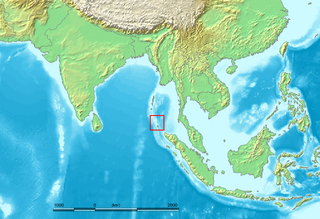
Paira is an island in the Nicobar district of Andaman and Nicobar Islands, India.
Nicobar district is one of three districts in the Indian union territory of Andaman and Nicobar Islands. The district's administrative territory encompasses all of the Nicobar Islands, which are located in the Indian Ocean, between the Bay of Bengal and the Andaman Sea. The headquarters of the district is the village of Malacca, located on the island of Car Nicobar.
The Andaman and Nicobar Islands, one of the seven union territories of India comprising 572 islands of which 37 are inhabited, are a group of islands at the juncture of the Bay of Bengal and Andaman Sea.
India, official name, the Republic of India,, is a country in South Asia. It is the seventh-largest country by area, the second-most populous country, and the most populous democracy in the world. Bounded by the Indian Ocean on the south, the Arabian Sea on the southwest, and the Bay of Bengal on the southeast, it shares land borders with Pakistan to the west; China, Nepal, and Bhutan to the north; and Bangladesh and Myanmar to the east. In the Indian Ocean, India is in the vicinity of Sri Lanka and the Maldives; its Andaman and Nicobar Islands share a maritime border with Thailand and Indonesia.
The island belongs to the township of Nancowry of Teressa Taluk. [4] [5]
The island is a part of the Nicobar Islands chain, located in the northeast Indian Ocean between the Bay of Bengal and the Andaman Sea. It is located 0.75 km (0.47 mi) NNW of Cape Maud of Tillanchong Island.
The Nicobar Islands are an archipelagic island chain in the eastern Indian Ocean. They are located in Southeast Asia, 150 km north of Aceh on Sumatra, and separated from Thailand to the east by the Andaman Sea. Located 1,300 km southeast of the Indian subcontinent, across the Bay of Bengal, they form part of the Union Territory of Andaman and Nicobar Islands, India.
The Indian Ocean is the third-largest of the world's oceanic divisions, covering 70,560,000 km2 (27,240,000 sq mi). It is bounded by Asia on the north, on the west by Africa, on the east by Australia, and on the south by the Southern Ocean or, depending on definition, by Antarctica.
The Bay of Bengal is the northeastern part of the Indian Ocean, bounded on the west and northwest by India, on the north by Bangladesh, and on the east by Myanmar and the Andaman Islands of India and Myanmar and the Nicobar Islands of India. Its southern limit is a line between Sri Lanka and the northwesternmost point of Sumatra (Indonesia). It is the largest water region called a bay in the world. There are countries dependent on the Bay of Bengal in South Asia and Southeast Asia.
Kakana is a village in the Nicobar district of Andaman and Nicobar Islands, India. It is located in the Nancowry tehsil.
Tapoiming is a village in the Nicobar district of Andaman and Nicobar Islands, India. It is located in the Car Nicobar tehsil.
Trinkat Bay is a village in the Nicobar district of Andaman and Nicobar Islands, India. It is located in the Great Nicobar tehsil. It is located between Lawful and Afra on Great Nicobar island.
Sawai is a village in the Nicobar district of Andaman and Nicobar Islands, India. It is located in the Car Nicobar tehsil.
Kalasi is a village in the Nicobar district of Andaman and Nicobar Islands, India. It is located in the Nancowry tehsil.
Altheak is a village in the Nicobar district of Andaman and Nicobar Islands, India. It is located in the Nancowry tehsil.
Pulloullo is a village in the Nicobar district of Andaman and Nicobar Islands, India. It is located on the Little Nicobar Island, and is administered as part of the Great Nicobar tehsil.
Shompen Village-B is a village in the Nicobar district of the Andaman and Nicobar Islands, India. It is located in the Great Nicobar tehsil.
Perka is a village in the Nicobar district of Andaman and Nicobar Islands, India. It is located in the Car Nicobar tehsil.
Lawful or Laful is a village in the Nicobar district of Andaman and Nicobar Islands, India. It is located in the Great Nicobar tehsil.
Katahu is a village in the Nicobar district of Andaman and Nicobar Islands, India. It is located in the Great Nicobar tehsil.
Pulomilo is an island in the Nicobar district of Andaman and Nicobar Islands, India, and home to a village of the same name. It is located just north of Little Nicobar Island,
Itoi is a village in the Nicobar district of Andaman and Nicobar Islands, India. It is located in the Nancowry tehsil.
Enam is a village in the Nicobar district of Andaman and Nicobar Islands, India. It is located in the Nancowry tehsil.
Alexandera River is a village in the Nicobar district of Andaman and Nicobar Islands, India. It is located in the Great Nicobar tehsil.
Kokeon is a village in the Nicobar district of Andaman and Nicobar Islands, India. It is located in the Great Nicobar tehsil.
Shompen Village-A is a village in the Nicobar district of Andaman and Nicobar Islands, India. It is located in the Great Nicobar tehsil.
Govinda Nagar is a village in the Nicobar district of Andaman and Nicobar Islands, India. It is located in the Great Nicobar tehsil. It was developed as a tsunami shelter to house people displaced by the 2004 Indian Ocean earthquake and tsunami.
Shompen hut is a village in the Nicobar district of Andaman and Nicobar Islands, India. It is located in the Great Nicobar tehsil.
![]() | This Andaman and Nicobar Islands location article is a stub. You can help Wikipedia by expanding it. |