
The Boston Post Road was a system of mail-delivery routes between New York City and Boston, Massachusetts, that evolved into one of the first major highways in the United States.
Bolton is a town in Worcester County, Massachusetts, United States. Bolton is in central Massachusetts, located 25 miles west-northwest of downtown Boston along Interstate 495. It is within Greater Boston and MetroWest regions. The population was 5,665 at the 2020 census.

Hopkinton is a town in Middlesex County, Massachusetts, United States, 25 miles (40 km) west of Boston. The town is best known as the starting point of the Boston Marathon, held annually on Patriots' Day each April, and as the headquarters for the Dell EMC corporation.

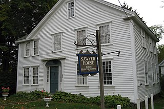
The Bolton Center Historic District is the historic center of the town of Bolton, Massachusetts. The district encompasses what is essentially a linear town center, strung out principally along Main Street, with a well-preserved collection of residential and civic architecture spanning more than two centuries. The district was listed on the National Register of Historic Places in 1996.

The Blackstone Canal was a manmade waterway, linking Worcester, Massachusetts, to Providence, Rhode Island, and Narragansett Bay, through the Blackstone Valley, via a series of locks and canals in the early 19th century. Construction started in 1825, and the canal opened three years later. After the opening of the Boston and Providence Railroad (1835), the canal struggled for business. Its transportation role was taken over by the Providence and Worcester Railroad, which completed a parallel line in 1847. The canal shut down in 1848. Several segments of the canal are preserved, and the canal alignment and remains are on the National Register of Historic Places.

The East Blackstone Village Historic District is a historic district roughly along Elm Street at the junction with Summer Street in eastern Blackstone, Massachusetts. It encompasses a small 19th-century mill village center that developed along what was once a major roadway connecting Worcester with Providence, Rhode Island. The district was added to the National Register of Historic Places in 1995.

The Pan Burying Ground is an historic cemetery on 477 Main Street in Bolton, Massachusetts. Established in 1822, the cemetery was the second in the town. It was named for the area known locally as "The Pan", which had by then become the second-largest village center in the town. The original 1.18-acre (0.48 ha) plot has 400 marked graves, and is presumed to contain further unmarked graves, based on a pattern of marker layout at the rear of this portion of the cemetery. The cemetery was enlarged to 3.3 acres (1.3 ha) in the 1960s. It is distinctive in Bolton for its seven-chambered group tomb, built in 1839 at the southeast corner of the property.

The Nathan Wood House is a historic house located in Westminster, Massachusetts. Built in 1756 by one of the town's early settlers, it is one of its oldest surviving buildings, and good example of colonial Georgian residential architecture. It was listed on the National Register of Historic Places on September 16, 1987.
The Ahijah Wood House is a historic house in Westminster, Massachusetts. The two story brick Federal style house was built in 1795 by the son of an early settler, and is a rare example of a Federal period house with a hipped mansard roof. The house was listed on the National Register of Historic Places in 1987.

The Frederick Fiske Warren and Gretchen Osgood Warren House, known to the family as The Hutch, is a historic house at 42 Bolton Road in Harvard, Massachusetts. Built in 1894, it was the summer home of Frederick Fiske Warren and Gretchen Osgood Warren, who organized a major enclave of Georgist single tax properties in Harvard. The property was added to the National Register of Historic Places in 1996.

The South Lancaster Engine House is a historic fire station at 283 South Main Street in South Lancaster, Massachusetts. Built in 1888, it is the town's oldest operating firestation, and a distinctive example of period Victorian architecture. The building was listed on the National Register of Historic Places in 1976. It presently houses engines 3 and 4 of the Lancaster Fire Department.

The Harvard Center Historic District is a historic district encompassing the traditional village center of Harvard, Massachusetts, USA. The district is centered on the town common, a triangular grassy space bounded by Elm Street, Still River Road, and Ayer Road. The common is ringed by residences, civic and religious buildings, and a small commercial area. The common was laid out when the town was founded in 1732, and has grown, mainly in periods of growth at the late 18th and late 19th/early 20th centuries. Most of the village's buildings post-date 1831. The district was added to the National Register of Historic Places in 1997.

The Templeton Common Historic District encompasses the historic town center of Templeton, Massachusetts. Laid out in the 1750s, the area has been the focus of the town's civic and economic affairs since, and includes its finest assortment of 18th and early 19th-century architecture. The district was added to the National Register of Historic Places in 1983. The district was in 2010 named as one of the 1,000 places to visit in Massachusetts by the Great Places in Massachusetts Commission.

Framingham station is a historic Boston and Albany Railroad station located in downtown Framingham, Massachusetts. Designed by noted American architect H. H. Richardson, it was one of the last of the railroad stations he designed in the northeastern United States to be built. The station, built in 1884–85, served as a major stop on the B&A Main Line as well as a hub for branch lines to Milford, Mansfield, Fitchburg, and Lowell. After years of deterioration, the station was listed on the National Register of Historic Places in 1975 as the Framingham Railroad Station, and restored a decade later.

The Brimfield Center Historic District is a historic district encompassing the historic center of Brimfield, Massachusetts. The district is centered on the town common, and includes properties radiating out from that center on Main Street, Brookfled, Wales, Sturbridge and Warren Roads. Brimfield Center was first laid out in 1721 along a Native American trail that ran through the area, and developed over the years into what is now US Route 20, or Main Street. The district includes properties ranging from early colonial houses to the town hall, built in 1878. The center has retained some coherence because the Brimfield Fair, a major antiques market that takes place three times a year, takes up significant open space in the areas near the center. The district was listed on the National Register of Historic Places in 2006.

The Marlborough Center Historic District is a historic district encompassing the civic and commercial heart of Marlborough, Massachusetts. It is centered on a stretch of Main Street between Mechanic Street to the west and Bolton Street to the east, and includes properties on adjacent streets. The center is reflective of the city's prosperity as an industrial center from the mid-19th century to the mid-20th century. The district was listed on the National Register of Historic Places in 1998.

The Lasell Neighborhood Historic District is a historic district roughly bounded by Woodland, Studio Roads, Aspen, Seminary Avenue, and Grove Street in Newton, Massachusetts - a village of Auburndale, Massachusetts. The area includes high-quality late - 19th and early - 20th century housing built in the area and includes buildings on the campus of Lasell University, established as the Auburndale Female Seminary in 1851. The district was listed on the National Register of Historic Places in 1986.
There are 112 properties and historic districts on the National Register of Historic Places in Worcester, Massachusetts, west of I-190 and the north–south section of I-290 and north of Massachusetts Route 122, which are listed here. Two listings overlap into other parts of Worcester: one of the 1767 Milestones is located in eastern Worcester, and the Blackstone Canal Historic District traverses all three sections of the city.
There are 291 properties and historic districts on the National Register of Historic Places in Worcester, Massachusetts. Of these, 82 are west of I-190 and the north-south section of I-290 and south of Massachusetts Route 122, and are listed below. One listing, the Blackstone Canal Historic District, overlaps into other parts of the city. Another listing has been removed.

The Southborough Center Historic District encompasses a historically significant portion of the town center of Southborough, Massachusetts. It extends from the Fay School grounds in the west, along Main Street to the railroad crossing east of Lanisquama Road. The area has been the town center since its founding in 1727, and now houses a diversity of 19th and early 20th-century architecture. The district was added to the National Register of Historic Places in 1990.


