Pattan, Khyber Pakhtunkhwa

Last updated
Pattan

پٹن
Tehsil, Union Council
Country Flag of Pakistan.svg  Pakistan
Province Khyber Pakhtunkhwa
District Lower Kohistan
Elevation833 m (2,733 ft)
Population (2017) [1]
  Total202,913
Time zone UTC+5 (PST)

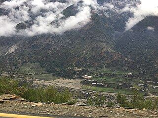
Pattan (پټن / پٹن) is the capital of Lower Kohistan District in the Khyber Pakhtunkhwa province of Pakistan.

Lower Kohistan District is a district in Hazara Division of Khyber Pakhtunkhwa province in Pakistan. The district headquarters of Lower Kohistan is Pattan.

Khyber Pakhtunkhwa Province in Pakistan

Khyber Pakhtunkhwa, formerly known as North-West Frontier Province, is one of the four administrative provinces of Pakistan, located in the northwestern region of the country along the international border with Afghanistan. It was previously known as the North-West Frontier Province until 2010 when the name was changed to Khyber Pakhtunkhwa by the 18th Amendment to Pakistan's Constitution, and is known colloquially by various other names. Khyber Pakhtunkhwa is the third-largest province of Pakistan by the size of both population and economy, though it is geographically the smallest of four. Within Pakistan, Khyber Pakhtunkhwa shares a border with Punjab, Balochistan, Azad Kashmir, Gilgit-Baltistan, and Islamabad. It is home to 17.9% of Pakistan's total population, with the majority of the province's inhabitants being Pashtuns. The province is the site of the ancient kingdom Gandhara, including the ruins of its capital Pushkalavati near modern-day Charsadda. Originally a stronghold of Buddhism, the history of the region was characterized by frequent invasions under various Empires due to its geographical proximity to the Khyber Pass.

Pakistan federal parliamentary constitutional republic in South Asia

Pakistan, officially the Islamic Republic of Pakistan, is a country in South Asia. It is the world’s sixth-most populous country with a population exceeding 212,742,631 people. In area, it is the 33rd-largest country, spanning 881,913 square kilometres. Pakistan has a 1,046-kilometre (650-mile) coastline along the Arabian Sea and Gulf of Oman in the south and is bordered by India to the east, Afghanistan to the west, Iran to the southwest, and China in the far northeast. It is separated narrowly from Tajikistan by Afghanistan's Wakhan Corridor in the northwest, and also shares a maritime border with Oman.

Contents

Climate

With a mild and generally warm and temperate climate, Pattan features a humid subtropical climate (Cfa) under the Köppen climate classification. The average temperature in Pattan is 19.6 °C, while the annual precipitation averages 802 mm. Even in the driest months, there is a lot of precipitation. November is the driest month with 17 mm of precipitation, while July, the wettest month, has an average precipitation of 123 mm.

Humid subtropical climate category in the Köppen climate classification system

A humid subtropical climate is a zone of climate characterized by hot and humid summers, and cool to mild winters. These climates normally lie on the southeast side of all continents, generally between latitudes 25° and 40° and are located poleward from adjacent tropical climates. While many subtropical climates tend to be located at or near coastal locations, in some cases they extend inland, most notably in China and the United States, where they exhibit more pronounced seasonal variations and sharper contrasts between summer and winter, as part of a gradient between the more tropical climates of the southern coasts of these countries and the more continental climates of China and the United States’ northern and central regions.

Köppen climate classification widely used climate classification system

The Köppen climate classification is one of the most widely used climate classification systems. It was first published by the Russian climatologist Wladimir Köppen (1846–1940) in 1884, with several later modifications by Köppen, notably in 1918 and 1936. Later, the climatologist Rudolf Geiger introduced some changes to the classification system, which is thus sometimes called the Köppen–Geiger climate classification system.

July is the hottest month of the year with an average temperature of 29.3 °C. The coldest month January has an average temperature of 7.9 °C.

Climate data for Pattan
MonthJanFebMarAprMayJunJulAugSepOctNovDecYear
Average high °C (°F)13.3
(55.9)
15.9
(60.6)
20.8
(69.4)
26.1
(79)
31.6
(88.9)
36.8
(98.2)
35.9
(96.6)
34.4
(93.9)
32.6
(90.7)
28.2
(82.8)
22.3
(72.1)
15.6
(60.1)
26.1
(79)
Daily mean °C (°F)7.9
(46.2)
10.3
(50.5)
14.7
(58.5)
19.7
(67.5)
24.5
(76.1)
29.2
(84.6)
29.3
(84.7)
28.3
(82.9)
25.7
(78.3)
20.6
(69.1)
15.0
(59)
9.6
(49.3)
19.6
(67.2)
Average low °C (°F)2.6
(36.7)
4.7
(40.5)
8.7
(47.7)
13.3
(55.9)
17.4
(63.3)
21.7
(71.1)
22.8
(73)
22.2
(72)
18.8
(65.8)
13.0
(55.4)
7.7
(45.9)
3.7
(38.7)
13.1
(55.5)
Source: Climate-Data.org [2]

See also

Related Research Articles

Swabi City in Khyber Pakhtunkhwa, Pakistan

Swabi or Sawabai is the capital of Swabi District in the Khyber Pakhtunkhwa province of Pakistan. It is located near the bank of the Indus River.

Mardan City in Khyber Pakhtunkhwa, Pakistan

Mardān is a city in the Mardan District of Khyber Pakhtunkhwa Province, Pakistan. Located in the Valley of Peshawar, Mardan is the second-largest city of Khyber Pakhtunkhwa, after the nearby city of Peshawar.

Battagram Place in Khyber Pakhtunkhwa, Pakistan

Battagram is the capital city of Battagram District in Khyber Pakhtunkhwa Province of Pakistan. It is located at 34°41'N 73°1'E and has an altitude of 1038 metres.

Saidu Sharif City in Khyber Pakhtunkhwa, Pakistan

Saidū Sharīf is the Capital City of Swat District in the Khyber Pakhtunkhwa province of Pakistan. The city also serves as the capital city of Malakand division. Named after Saidu Baba, a prominent leader of the former Yusufzai State of Swat.

Mingora City in Khyber Pakhtunkhwa, Pakistan

Mingora is a commercial city in the Swat District of Khyber Pakhtunkhwa, Pakistan, located at an altitude of 984 metres (3,228 ft), 2 km (1.2 mi) away from the town of Saidu Sharif. Mingora is the largest city in Malakand Division, and also the largest in the northern part of Khyber Pakhtunkhwa. Mingora is a major tourist destination, with a large number of hotels.

Kalam Valley Valley in Khyber Pakhtunkhwa, Pakistan

Kalam is a valley located at distance of 99 kilometres (62 mi) from Mingora in the northern upper reaches of Swat valley along the bank of Swat River in Khyber Pakhtunkhwa province of Pakistan. Kalam is surrounded by lush green hills, thick forests and bestowed with mesmeric lakes, meadows and waterfalls which are worth seen features of the landscape. It is the birthplace of Swat river which forms with confluence of two major tributaries of Gabral river and Ushu river.

Thakot Town and union council in Khyber Pakhtunkhwa, Pakistan

Thakot or Takot is a tribal town on the Indus River in Battagram District of Khyber Pakhtunkhwa, Pakistan. It is also one of twenty Union Councils of Battagram District, and one of twelve in Battagram Tehsil. Thakot is located midway between Battagram town in the south and Besham town in the north, at a distance of about 30 km from both.

Alpuri Place in Khyber-Pakhtunkhwa, Pakistan

Alpuri or Alpurai is the capital of Shangla District in the Khyber-Pakhtunkhwa province of Pakistan. It is located at 34°54′00″N72°39′00″E and has an average elevation of 1587 meters. The place has a government degree college and District headquarters hospital.

Besham Place in Khyber Pakhtunkhwa, Pakistan

Besham is the largest town and commercial centre of the Shangla District in Khyber-Pakhtunkhwa province of Pakistan. Most of the population consists of Pashto-speaking Pashtuns.

Aliabad, Hunza Town in Gilgit–Baltistan, Pakistan

Aliabad is the administrative and commercial center of the Hunza District of Gilgit–Baltistan, Pakistan.

Dasu District Headquarter in Khyber Pakhtunkhwa, Pakistan

Dasu or Dassu is the district headquarters of Upper Kohistan District, Khyber Pakhtunkhwa, Pakistan. It had 15 Union Councils before the separation of the Kandia valley. Since its being named as Tehsil, the Dasu subdivision has 11 Union Councils. The total population of Dasu according to 1998 Census was 137,519, in 21,487 households.

Torkham, Pakistan Town in Khyber Pakhtunkhwa, Pakistan

Not to be confused with the Torkham, a major international crossing with Afghanistan.

Jilikul Place in Khatlon Province, Tajikistan

Jilikul is the capital of the Jilikul District of the Khatlon Province, Tajikistan. It is located in the southwestern portion of Tajikistan approximately 117km from Dushanbe.

Kolai is an administrative unit, known as Union council of Kohistan District in the Khyber Pakhtunkhwa province of Pakistan.

Sagayun is an administrative unit, known as Union council of Kohistan District in the Khyber Pakhtunkhwa province of Pakistan.

Thoti is an administrative unit, known as Union council of Kohistan District in the Khyber Pakhtunkhwa province of Pakistan.

Harban is an administrative unit, known as Union council of Kohistan District in the Khyber Pakhtunkhwa province of Pakistan.

Bahrain, Swat Town in Khyber Pakhtunkhwa, Pakistan

Bahrain is a town located in Swat District of Khyber Pakhtunkhwa, Pakistan, 60 km North of Mingora at an elevation of 4700 ft on the right bank of the Swat river. It is named Bahrain due to its location at the confluence of the Daral and Swat rivers. It is known for its riverside tourist resorts, local handicrafts, and its view of the merging of the Daral and Swat Rivers. It also serves as a base camp for the trail that leads to the Daral & Saidgai lakes.

Khwazakhela Tehsil in Khyber Pakhtunkhwa, Pakistan

Khwazakhela is a town and an administrative subdivision (Tehsil) of Swat District in the Khyber Pakhtunkhwa province of Pakistan.

References

  1. "DISTRICT AND TEHSIL LEVEL POPULATION SUMMARY WITH REGION BREAKUP: KHYBER PAKHTUNKHWA" (PDF). Pakistan Bureau of Statistics. 2018-01-03. Retrieved 2018-04-20.
  2. "Climate: Patan - Climate-Data.org" . Retrieved 15 September 2016.