
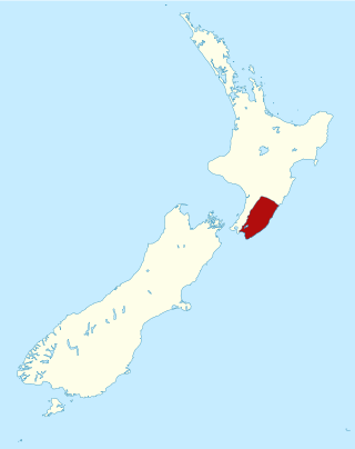
Hawke's Bay is a region on the east coast of New Zealand's North Island. The region is named for Hawke Bay, which was named in honour of Edward Hawke. The region's main centres are the cities of Napier and Hastings, while the more rural parts of the region are served by the towns of Waipukurau, Waipawa, and Wairoa.
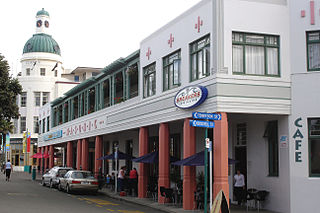
Napier is a city on the eastern coast of the North Island of New Zealand and the seat of the Hawke's Bay region. It is a beachside city with a seaport, known for its sunny climate, esplanade lined with Norfolk pines, and extensive Art Deco architecture. For these attributes, Napier is sometimes romantically referred to as the "Nice of the Pacific".

Hastings is an inland city of New Zealand and is one of the two major urban areas in Hawke's Bay, on the east coast of the North Island. The population of Hastings is 52,200, with a further 14,900 people in Havelock North and 2,120 in Clive. Hastings is about 18 kilometres inland of the coastal city of Napier. These two neighbouring cities are often called "The Bay Cities" or "The Twin Cities".
The Wairarapa, a geographical region of New Zealand, lies in the south-eastern corner of the North Island, east of metropolitan Wellington and south-west of the Hawke's Bay Region. It is lightly populated, having several rural service towns, with Masterton being the largest. It is named after its largest lake, Lake Wairarapa.
Waipukurau is the largest town in the Central Hawke's Bay District on the east coast of the North Island of New Zealand. It is located on the banks of the Tukituki River, 7 kilometres south of Waipawa and 50 kilometres southwest of Hastings.

Lake Wairarapa is a lake at the southern end of the North Island of New Zealand, 50 kilometres (31 mi) east of Wellington. The lake covers an area of 78 km2 (30 sq mi), and at its deepest is 2.5 m (8.2 ft). It is the third largest in the North Island, fractionally smaller than Lake Rotorua. The nearest town to the lake is Featherston, which is located five kilometres from its northern shore.

The Tukituki River is in the Hawke's Bay region of the eastern North Island of New Zealand. It flows from the Ruahine Ranges to the Pacific Ocean at the southern end of Hawke Bay.
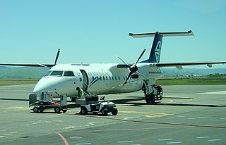
Hawke's Bay Airport, commonly referred to as Napier Airport, is Hawke's Bay's main commercial airport, serving domestic flights to the main centres of Auckland, Wellington and Christchurch, and smaller centres such as Gisborne. The airport is located in the north of Napier and 20.7 km from Hastings.

Regional parks of New Zealand are protected areas administered by regional councils, the top tier of local government. Regional parks are found across several regions of New Zealand: the Auckland Region, Waikato Region, Bay of Plenty Region, Hawkes Bay Region, Wellington Region and Canterbury Region. Regional parks in the Auckland and Waikato regions are administered by the Auckland Council, while parks in other areas are administered by regional councils: the Bay of Plenty Regional Council, Hawke's Bay Regional Council, Greater Wellington Regional Council, and Canterbury Regional Council.
The Waipawa River is a braided river of southern Hawke's Bay, in New Zealand's eastern North Island. It flows southeast from the slopes of 1,687 m (5,535 ft) Te Atuaoparapara in the Ruahine Range, past the town of Waipawa, before joining the Tukituki River. The river rises at the 1,326 m (4,350 ft) Waipawa Saddle, which is also the source of the Waikamaka River. The Mangaonuku Stream is a tributary on the northern bank, west of Waipawa, near Ruataniwha. The Waipawa's flow is generally greater than that of the Tukituki River, into which it flows.
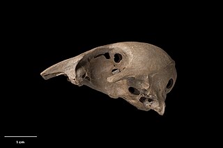
The New Zealand stiff-tailed duck is an extinct duck species from New Zealand which is known only from subfossil remains. It was first described as a distinct species by Trevor H. Worthy in 2005.
Lake Poukawa is a small shallow hardwater lake in the Hawke's Bay Region, North Island, New Zealand. It is located about 20 km south-west of Hastings, New Zealand, close to the settlement of Te Hauke. It is the largest lake lying within a peatland in the active tectonic Poukawa depression, between the Raukawa Range and Kaokaoroa Range of central Hawke's Bay. Its maximal depth is less than one metre and its diameter is ca. 1.5 km. It was deeper in the past but it was artificially drained after the 1931 Hawke's Bay earthquake. Lake Poukawa is drained by the Poukawa Stream, which flows north-eastward through the Pekapeka Wetland and eventually into the Clive River.
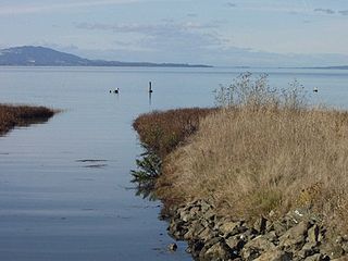
The Dotson Family Marsh, formerly Breuner Marsh, is a 238-acre regional park on San Pablo Bay in the East San Francisco Bay Area city of Richmond, California. In 2009 the East Bay Regional Parks District acquired the Breuner Marsh site, adding it to Point Pinole Regional Shoreline. A habitat restoration plan for 60 acres (24 ha) of wetlands and 90 acres (36 ha) of California coastal prairie was subsequently approved.

Hugh McLean Campbell, sometimes known as HM Campbell, was a Reform Party Member of Parliament in New Zealand.
Awatoto is a coastal suburb area within the city of Napier, Hawke's Bay, New Zealand. It stretches along the coast south of Te Awa and the central city. The northern part of Awatoto is residential, while the southern part is industrial, including heavy industry.
Hatuma is 7 km (4.3 mi) south of Waipukurau, in Central Hawke's Bay in the east of the North Island of New Zealand. Meshblock 7016748, which covers 19.3 km2 (7.5 sq mi) from the edge of Waipukurau to Marakeke, had a population of 153 in 2018.

Whitireia Park is a headland north of Tītahi Bay and Te Awarua-o-Porirua Harbour in Porirua, in the Wellington Region at the southern end of New Zealand's North Island. It is a park administered by the Whitireia Park Board, in collaboration with Wellington Regional Council. The park includes Onehunga Bay, Kaitawa Point and part of Rocky Bay.
Whakanewha Regional Park is a regional park situated on Waiheke Island in New Zealand's Hauraki Gulf. It is owned and operated by Auckland Council.

The 2022 Hawke's Bay local elections were held on 8 October 2022 as part of the wider 2022 New Zealand local elections to elect members to sub-national councils and boards. These elections covered one regional council, four territorial authorities, a rural community board, and a licensing trust.
The 2019 Hawke's Bay local elections were held on 12 October 2019 as part of the wider 2019 New Zealand local elections to elect members to sub-national councils and boards. These elections covered one regional council, four territorial authorities, a district health board, a licensing trust, and a rural community board.

