Perley Bridge | |
---|---|
![]() Postcard image of the Perley Bridge | |
Coordinates | 45°22′14″N74°21′19″W / 45.3706°N 74.3552°W |
Carries | road vehicles, pedestrians, bicycles |
Crosses | Ottawa River |
Locale | Ontario–Quebec border |
Named for | George Perley |
Preceded by | Macdonald-Cartier Bridge |
Followed by | Lake of Two Mountains |
Characteristics | |
Design | truss |
Material | Concrete & steel |
Pier construction | concrete |
Total length | 2,284 feet (696 m) |
Width | 24 feet (7.3 m) (roadway) |
Traversable? | yes |
History | |
Constructed by | Canadian Bridge Company |
Construction end | 1931 |
Rebuilt | 1961 |
Closed | 1998 |
Replaced by | Long-Sault Bridge |
Statistics | |
Daily traffic | 11,000–12,000 (1970s) |
Location | |
![]() |
The Perley Bridge was a bridge connecting Hawkesbury, Ontario and Grenville, Quebec. It crossed the Ottawa River via Chenail Island. It was named for George Perley, Canadian Member of Parliament representing the Argenteuil district in southern Quebec. [1] He first advocated for a crossing at Hawkesbury in 1909. [2] The bridge was known as the Hawkesbury–Grenville Bridge, or less frequently the Grenville–Hawkesbury Bridge prior to its completion in 1931 when the name Perley was applied. It was replaced by the Long-Sault Bridge in 1998.
The towns began to request the bridge in 1908, with initial survey work done in 1910. The bridge was designed by 1914, [2] however no agreement was reached between the national government and the two provinces on how the cost would be shared. The project was put aside due to World War I and not revived until 1923. By then, the design needed to be revised to meet contemporary construction standards. Redesign work was completed in 1924, but construction would wait a further six years. [3] Bids for the fabrication of the bridge superstructure were not solicited until July 1930. [4] It was completed in 1931, at a cost of approximately $500,000, [5] opening to traffic on October 21. [1] The steel was fabricated by the Canadian Bridge Company of Walkerville, Ontario [6] and the general contractor was Farley & Grant. [7] The bridge was 2,284 feet (696 m) in length (measured between abutments) and included 34 different spans, 27 of which were trestle spans over the shallower area on either end. The others were five longer deck truss spans set on piers in deeper water, one through truss which gave the maximum clearance over the navigation channel near the middle of the river, and one bowstring truss over the Carillon Canal. The roadway was 24 feet (7.3 m) wide and carried one traffic lane in each direction, with an additional 5-foot-wide (1.5 m) sidewalk on one side. All piers were set on bedrock. [2]
A dedication ceremony was held on the day of opening, with remarks by Hugh Stewart, the Canadian Minister of Public Works and a ribbon cutting by the wife of the bridge's namesake, George Perley. [5] The bridge was blessed by the Roman Catholic Archbishop of Ottawa. The mayors of Hawkesbury and Grenville both spoke. The ceremony was preceded by parades from each town to the center of the bridge, where a special pavilion and been constructed. Also present were Perley, Élie-Oscar Bertrand MP of Prescott, and other government officials. Both Hawkesbury and Grenville declared the half-day starting at noon to be a holiday. [3]
In 1940, the proposed route of the Trans-Canada highway in eastern Ontario ran from Ottawa on Highway 17 to Hawkesbury and then across the bridge and on into Quebec. [8] The highway was not formally enacted until 1949. Today, it traverses the area farther south on Highway 417 and crosses the river via the Île aux Tourtes Bridge outside Montreal.
Little was done to the bridge except routine maintenance such as painting until 1961, when a major modification occurred and the bridge was raised 8 to 10 feet (2.4 to 3.0 m). [9] This was necessary to maintain a navigational clearance of 42 feet (13 m) after the construction of the dam at the Carillon Generating Station, [2] a hydroelectric power station that was built between 1959 and 1964 approximately 12 mi (19 km) downstream from the bridge. Upon completion, the dam raised the water level by over 9 feet (2.7 m) at the bridge. [10] The six truss spans in the center of the bridge were jacked higher by the Dominion Bridge Company. In preparation, the bridge was restricted to one lane for two months. Then, on December 13, all traffic was halted for 19 hours when the bridge was raised and then reopened to traffic. [11]
The bridge lighting was upgraded in 1965 [12] with 250-watt mercury lamps. [13]
Maintenance of other inter-province bridges is shared by the national government and the provinces, each paying one-third of the cost. However, since Quebec paid a large share of the original construction cost, it was not responsible for maintenance. Ontario paid 25% of the costs, while Canada paid the remainder. [14]
The bridge was painted twice after the reconstruction, in 1963 and again in 1972–73. On March 4, 1973, a corner of one of the south trestle spans failed, dropping the roadway several inches. The bridge was quickly repaired and reopened to all traffic three days later. [15] The failure led to an assessment of the safety of the bridge that began in 1973 by Public Works Canada, the Ministry of Transportation and Communications, and an Ottawa consulting engineer firm, M.M. Dillon Ltd. [2]
Underwater inspection determined the piers were in good condition. The above-water superstructure, made mostly from open hearth steel was found to have many areas of severe corrosion and metal fatigue, including bearings, connecting angles, floor beams (some had been reduced in size by 50%), steel decking, expansion joints, and railing. [2]
The study also looked at traffic and determined 11,000 to 12,000 vehicles crossed the bridge on average summer weekdays, 20% to 30% of which were trucks, including heavy logging trucks delivering timber from Quebec to a Hawkesbury paper mill, as well as various other kinds of heavy loads. It concluded that the bridge was carrying loads much in excess of is designed capacity. [2]
Work was performed at the time to strengthen the structure so that it would support 80,000-pound (36,000 kg) loads. The work included various reinforcements and strengthening of the structure, including adding braces and replacing some rivets with high-strength bolts, and was considered a "short-term" solution. [2] On October 22, 1974, signs were posted restricting loads to 80,000 lb (36,000 kg) and a control station on the Quebec side enforced this weight limit. After three months the Quebec government stopped staffing the control station, leading an MP to question if the bridge would last another three to five years. [16]
One $280,000 repair was made in 1975. [17] Other repairs were completed in 1978 and 1979. [2] The Marshall Steel Company of Laval, Quebec was awarded one contract for over $740,000 to strengthen trusses on the bridge. [18]
Long-term upgrades were needed to achieve a load capacity of 162,500 lb (73,700 kg). One option considered was using the bridge for automobile traffic only and building a new bridge for heavy truck traffic. The other option was to upgrade the bridge to be able to carry heavy truck traffic on one lane and building a new bridge that would also have one lane for truck and another for cars. Total replacement was not considered because of the perceived value of the existing bridge. [2] However, it was reported as early as 1974 that Public Works Canada felt a new bridge was considered necessary. [19] At the time, an agreement for funding a new bridge could not be reached by the three involved governments. [16]
Corrosion in a section of the deck that had been rehabilitated in 1979 was observed in 1985. [20]
In 1986, agreement was reached by the Ottawa and Quebec provincial representatives and Don Boudria, MP for Glengarry–Prescott–Russell to support total replacement of the bridge, as had been sought by the Grenville and Hawkesbury municipal governments. Boudria said the bridge was in "a deplorable condition". [21]
The Perley bridge was demolished in 1999 after the replacement bridge, built 80 ft (24 m) to the west, was opened. [22]
Sections of the deck repaired in 1979 were cut out and transported to the laboratories of the Institute for Research in Construction (IRC) at the National Research Council (Canada), [23] and the U.S. Department of Energy's (DOE) Albany Research Center [24] for further examination. At the IRC, corrosion of epoxy-coated-rebar was studied by half-cell potential, linear polarization, and concrete resistivity measurement. [25] At the DOE, scanning electron microscopy and X-ray wavelength analysis were used, with results analyzed by the University of Waterloo. [24] A study determined that epoxy-coated-rebar, which was expected to greatly extend the life of the bridge deck, in fact offered only 1–4 years more protection than uncoated rebar. [20]
The bridge has more closely joined Hawkesbury, with an 86% French-speaking population, and Grenville. [26]
Rebar, known when massed as reinforcing steel or steel reinforcement, is a tension device added to concrete to form reinforced concrete and reinforced masonry structures to strengthen and aid the concrete under tension. Concrete is strong under compression, but has low tensile strength. Rebar usually consists of steel bars which significantly increase the tensile strength of the structure. Rebar surfaces feature a continuous series of ribs, lugs or indentations to promote a better bond with the concrete and reduce the risk of slippage.
The Manhattan Bridge is a suspension bridge that crosses the East River in New York City, connecting Lower Manhattan at Canal Street with Downtown Brooklyn at the Flatbush Avenue Extension. Designed by Leon Moisseiff and built by the Phoenix Bridge Company, the bridge has a total length of 6,855 ft (2,089 m). It is one of four toll-free vehicular bridges connecting Manhattan Island to Long Island; the nearby Brooklyn Bridge is just slightly farther west, while the Queensboro and Williamsburg bridges are to the north.
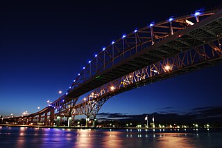
The Blue Water Bridge is a twin-span international bridge across the St. Clair River that links Port Huron, Michigan, United States, and Point Edward, Ontario, Canada. The Blue Water Bridge connects Highway 402 in Ontario with both Interstate 69 (I-69) and Interstate 94 (I-94) in Michigan.
The Champlain Bridge was a steel truss cantilever bridge with approach viaducts constructed of prestressed concrete beams supporting a prestressed concrete deck paved with asphalt. Opened in 1962, the bridge crossed the Saint Lawrence River, connecting the Island of Montreal to its South Shore suburbs.
The Royal Alexandra Interprovincial Bridge, also known as the Alexandra Bridge or Interprovincial Bridge, is a steel truss cantilever bridge spanning the Ottawa River between Ottawa, Ontario and Gatineau, Quebec. In addition to carrying vehicle traffic, a shared use pathway on the bridge for pedestrians and cyclists is maintained by the National Capital Commission.
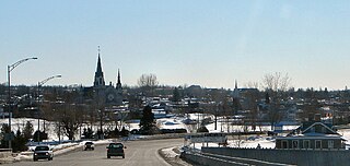
Hawkesbury is a town in the United Counties of Prescott and Russell in Eastern Ontario, Canada. Hawkesbury is the third most bilingual town in Ontario, with about 70% of its inhabitants being fluent in English and French. Franco-Ontarians make up 89% of the population.
A truss bridge is a bridge whose load-bearing superstructure is composed of a truss, a structure of connected elements, usually forming triangular units. The connected elements, typically straight, may be stressed from tension, compression, or sometimes both in response to dynamic loads. There are several types of truss bridges, including some with simple designs that were among the first bridges designed in the 19th and early 20th centuries. A truss bridge is economical to construct primarily because it uses materials efficiently.
The Burlington Bay James N. Allan Skyway, originally called the Burlington Bay Skyway and simply known as the Burlington Skyway or The Skyway, is a pair of high-level freeway bridges spanning the Burlington Bay Canal. The Skyway, as it is locally known, is located in Hamilton and Burlington, Ontario, Canada, and is part of the Queen Elizabeth Way (QEW) highway linking Fort Erie with Toronto. The 1958 steel bridge is a suspended deck through-arch truss bridge. The approach to the main span has elements of a through-truss bridge, but the arch shape takes the truss higher than the roadway deck, so hangers are used to suspend the deck from the arch truss. The truss bridge is 2,560 m (8,400 ft) long overall. The main span of 151 m (495 ft) is flanked by two back spans each 83.7 m (275 ft) long; there are 72 total approach spans, and the bridge has 36.7 m (120 ft) of vertical clearance below the bottom of the deck. The girder bridge, completed in 1985, is 335 m (1,099 ft) shorter. The roadway deck for each bridge is 30 m (97 ft) wide.
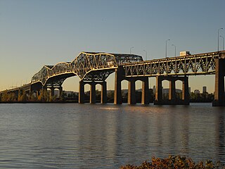
The Honoré Mercier Bridge in Quebec, Canada, connects the Montreal borough of LaSalle on the Island of Montreal with the Mohawk reserve of Kahnawake and the suburb of Châteauguay on the south shore of the Saint Lawrence River. It is the most direct southerly route from the island of Montreal toward the US border. It carries Route 138, originally Route 4. It is 1.361 km (0.846 mi) in length and contains four steel trusses on its first section. The height of the bridge varies from 12.44 m (40.8 ft) to 33.38 m (109.5 ft) with the highest sections located over the St. Lawrence Seaway. The bridge is named after former premier of Quebec Honoré Mercier.
The Seal Island Bridge is a bridge located in Victoria County, Nova Scotia. It is the third longest bridge span in the province.
The Hawkesbury River railway bridge is a heritage-listed railway bridge in New South Wales, Australia that carries the Main North railway line across the Hawkesbury River. The bridge crosses between Brooklyn on the northern outskirts of Sydney and Cogra Bay in the Central Coast region. The railway bridge was to be the last link in a railway network that linked the state capitals Adelaide, Melbourne, Sydney and Brisbane and was a major engineering feat at the time. The original railway bridge was built in 1889 and replaced by the current bridge in 1946. The 1946 bridge was added to the New South Wales State Heritage Register on 2 April 1999.
Grenville is a village municipality in the Argenteuil Regional County Municipality of the Laurentides region of Quebec, Canada. It is located opposite Hawkesbury, Ontario, on the Ottawa River.
The Carillon generating station is a hydroelectric power station on the Ottawa River near Carillon, Quebec, Canada. Built between 1959 and 1964, it is managed and operated by Hydro-Québec. It is a run-of-river generating station with an installed capacity of 752 megawatts (1,008,000 hp), a head of 17.99 meters (59.0 ft), and a reservoir of 26 square kilometers (10 sq mi). The dam spans the river between Carillon and Pointe-Fortune, Quebec.
The Peats Ferry Bridge is a steel truss bridge that carries the Pacific Highway (B83) across the Hawkesbury River, between Kangaroo Point and Mooney Mooney Point, located 40 kilometres (25 mi) north of Sydney in New South Wales, Australia. The bridge carries the Hornsby to Kariong section of highway, while the adjacent Brooklyn Bridge carries the Pacific Motorway (M1).
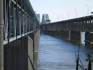
The Long-Sault Bridge is a bridge connecting Hawkesbury, Ontario and Grenville, Quebec. It crosses the Ottawa River via Chenail Island. It connects Quebec Route 344 and Ontario Highway 34, and is the only fixed crossing of the Ottawa River between Ottawa and Montreal.
The San Mateo–Hayward Bridge is a bridge crossing the American state of California's San Francisco Bay, linking the San Francisco Peninsula with the East Bay. The bridge's western end is in Foster City, a suburb on the eastern edge of San Mateo. The eastern end of the bridge is in Hayward. It is the longest fixed-link bridge in California and the 25th longest in the world by length. The bridge is owned by the state of California, and is maintained by California Department of Transportation (Caltrans), the state highway agency. Further oversight is provided by the Bay Area Toll Authority (BATA).
On May 23, 2013, at approximately 7:00 pm PDT, a span of the bridge carrying Interstate 5 over the Skagit River in the U.S. state of Washington collapsed. Three people in two different vehicles fell into the river below and were rescued by boat, escaping serious injury. The cause of the catastrophic failure was determined to be an oversize load striking several of the bridge's overhead support beams, leading to an immediate collapse of the northernmost span.
Chenail Island is an uninhabited island in the Ottawa River of Ontario, Canada. It is part of the town of Hawkesbury, Ontario, and across the river from Grenville, Quebec. The only road on the island, the four-lane St. John Street, connects Ontario Highway 34 in Hawkesbury and Quebec Route 344 in Grenville via the Perley Bridge and its replacement, the Long-Sault Bridge.
The Carillon and Grenville Railway (CAGR) was a 5 ft 6 in broad gauge portage railway in Quebec, running approximately 12 miles (19 km) between the towns of Carillon and Grenville on the north bank of the Ottawa River. It provided a through-route from Ottawa to Montreal via steamships on either side of the Long Sault Rapids. It was one of Canada's earliest railways, opened in 1854, and was the last operational broad gauge railway in Canada when it closed in 1910.
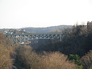
The Charles Anderson Memorial Bridge is a steel deck truss bridge located in Pittsburgh, Pennsylvania, United States. The bridge carries the four-lane roadway of Boulevard of the Allies across a ravine known as Junction Hollow, connecting the neighborhoods of Central Oakland and South Oakland with Schenley Park. The bridge also spans the Junction Hollow Trail and P&W Subdivision railroad tracks which run along the bottom of the valley.
{{cite journal}}
: Cite journal requires |journal=
(help){{cite journal}}
: Cite journal requires |journal=
(help)