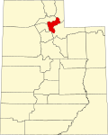
Peterson, Utah

Last updated
Peterson, Utah
Peterson, Utah.jpg
An intersection in Peterson, Utah, June 2009
USA Utah location map.svg
Red pog.svg
Peterson
Location of Peterson within the State of Utah
Coordinates: 41°07′05″N111°46′04″W / 41.11806°N 111.76778°W / 41.11806; -111.76778 Coordinates: 41°07′05″N111°46′04″W / 41.11806°N 111.76778°W / 41.11806; -111.76778
Country United States
State Utah
County Morgan
Settled1855
Named for Charles Sreeve Peterson
Elevation
[1]
4,885 ft (1,489 m)
Time zone UTC-7 (Mountain (MST))
  Summer (DST) UTC-6 (MDT)
GNIS feature ID1444301 [1]

Peterson is an unincorporated community in northwestern Morgan County, Utah, United States. [1]

Contents

Geography

Peterson is located in northwest Morgan Valley, near Peterson Creek and Interstate 84, 7 miles (11 km) northwest of the town of Morgan. [2] [3]

Thurston Peak, the highest peak in the county at an elevation of 9,706 feet (2,958 m), is located near Peterson. [4]

Historical population
CensusPop.
1880 301
1890 271−10.0%
1900 30211.4%
1910 277−8.3%
1920 31212.6%
1930 308−1.3%
1940 40029.9%
1950 289−27.7%
Source: U.S. Census Bureau [5]

History

Peterson was first settled in 1855. It was originally named Weber City after the nearby Weber River. The first public building, a combination school and LDS Church, was opened in 1861. The town was designated county seat in 1862, and remained so for four years, until it was replaced by Littleton in 1866, and then Morgan in 1868. [6] The Peterson General Store, which also housed a U.S. post office, opened in 1869. Other businesses included the Dexter Hotel, a train station, and a stockyard. [6]

In 1872, the town's name was changed to Peterson to honor an early settler, Charles Sreeve Peterson. Peterson was a Mormon leader, and the first settler of Morgan County. [3] [6]

See also

Flag of Utah.svg  Utahportal

Related Research Articles

Davis County, Utah County in Utah, United States

Davis County is a county in northern Utah, United States. As of the 2010 United States Census, the population was 306,479, making it Utah's third-most populous county. Its county seat is Farmington, and its largest city is Layton.

Rich County, Utah County in Utah, United States

Rich County is a county in the U.S. state of Utah. As of the 2010 United States Census, the population was 2,264, making it the third-least populous county in Utah. Its county seat is Randolph, and the largest town is Garden City. The county was created in 1864. It was named for an early LDS apostle, Charles C. Rich.

Morgan County, Utah County in Utah, United States

Morgan County is a county in northern Utah, United States. As of the 2010 census, the population was 9,469. Its county seat and largest city is Morgan. Morgan County is part of the Ogden-Clearfield, UT Metropolitan Statistical Area as well as the Salt Lake City-Provo-Orem, UT Combined Statistical Area.

Howell, Utah Town in Utah, United States

Howell is a town located in the Blue Creek Valley in northeast Box Elder County, Utah, United States. The population was 245 at the 2010 census.

Richmond, Utah City in Utah, United States

Richmond is a city in Cache County, Utah, United States. The population was 2,470 at the 2010 census, with an estimated population of 2,730 in 2018. It is included in the Logan metropolitan area.

Clearfield, Utah City in Utah, United States

Clearfield is a city in Davis County, Utah, United States. The population was 31,364 at the 2020 census. The city grew rapidly during the 1940s, with the formation of Hill Air Force Base, and in the 1950s with the nationwide increase in suburb and "bedroom" community populations and has been steadily growing since then.

Roosevelt, Utah City in Utah, United States

Roosevelt is a city in Duchesne County, Utah, United States. The population was 6,046 at the 2010 census, with an estimated population of 7,070 in 2018.

Escalante, Utah City in Utah, United States

Escalante is a city in central Garfield County, Utah, United States, located along Utah Scenic Byway 12 (SR-12) in the south central part of the state. As of the 2010 census, there were 797 people living in the city.

Blanding, Utah City in Utah, United States

Blanding is a city in San Juan County, Utah, United States. The population was 3,375 at the 2010 census, making it the most populated city in San Juan County. It was settled in the late 19th century by Mormon settlers, predominantly from the famed Hole-In-The-Rock expedition. Economic contributors include mineral processing, mining, agriculture, local commerce, tourism, and transportation.

Vernon, Utah Town in Utah, United States

Vernon is a town in southeastern Tooele County, Utah, United States.

North Bend, Washington City in Washington, United States

North Bend is a city in King County, Washington, United States, on the outskirts of the Seattle metropolitan area. The population was 5,731 at the 2010 census and an estimated 7,136 in 2018.

Lacey, Washington City in Washington, United States

Lacey is a city in Thurston County, Washington, United States. It is a suburb of Olympia with a population of 53,526 at the 2020 census. Lacey is located along Interstate 5 between Olympia and the Nisqually River, which marks the border with Pierce County and Joint Base Lewis–McChord.

Tenino, Washington City in Washington, United States

Tenino is a city in Thurston County, Washington, United States. The population was 1,870 at the 2020 census.

Hanksville, Utah Town in Utah, United States

Hanksville is a small town in Wayne County, Utah, United States, at the junction of State Routes 24 and 95. The population was 219 at the 2010 census.

Chester is an unincorporated community in central Sanpete County, Utah, United States.

Gunlock is an unincorporated community in western Washington County, Utah, United States, north of Gunlock State Park.

Rosette is an unincorporated ranching community in northwestern Box Elder County, Utah, United States.

West Weber, Utah Unincorporated community in the State of Utah, United States

West Weber is a township and unincorporated community in western Weber County, Utah, United States.

Enterprise, Morgan County, Utah CDP in Utah, United States

Enterprise is a census-designated place (CDP) in northwestern Morgan County, Utah, United States. The population was 605 at the 2010 census.

Dalton Creek is a stream in Morgan County, Utah, United States. It is also located within the Uinta-Wasatch-Cache National Forest and its mouth is about 1.75 miles (2.82 km) southeast of Peterson.

References

  1. 1 2 3 "Peterson". Geographic Names Information System . United States Geological Survey.
  2. "MyTopo Maps - Peterson, Utah, USA" (Map). mytopo.com. Trimble Navigation, Ltd. Retrieved 16 Mar 2018.
  3. 1 2 Van Cott, John W. (1990). Utah Place Names: A Comprehensive Guide to the Origins of Geographic Names: A Compilation. Salt Lake City: University of Utah Press. p. 293. ISBN   978-0-87480-345-7. OCLC   797284427 . Retrieved 16 Mar 2018.
  4. Thurston Peak
  5. "Census of Population and Housing". census.gov. United States Census Bureau . Retrieved 7 Nov 2011.
  6. 1 2 3 "The Settlements of Morgan County", Morgan County Utah Historical Society. Accessed 21 Jun 2009.

Commons-logo.svg Media related to Peterson, Utah at Wikimedia Commons