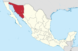
Sonora, officially Estado Libre y Soberano de Sonora, is one of the 31 states which, along with Mexico City, comprise the Federal Entities of Mexico. The state is divided into 72 municipalities; the capital city of which being Hermosillo, located in the center of the state. Other large cities include Ciudad Obregón, Nogales, San Luis Río Colorado, and Navojoa.
Oʼodham or Papago-Pima is a Uto-Aztecan language of southern Arizona and northern Sonora, Mexico, where the Tohono Oʼodham and Akimel Oʼodham reside. In 2000 there were estimated to be approximately 9,750 speakers in the United States and Mexico combined, although there may be more due to underreporting.
Huarijio is a Uto-Aztecan language of the states of Chihuahua and Sonora in northwestern Mexico. It is spoken by around 2,100 Huarijio people, most of whom are monolinguals.
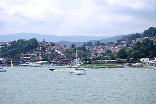
Valle de Bravo is one of 125 municipalities in the State of Mexico, Mexico. The largest town and municipal seat is the town of Valle de Bravo. It is located on the shore of Lake Avándaro, approximately 156 km southwest of Mexico City and west of Toluca on highways 15, 134 or 1. It takes about two hours to drive from Mexico City to Valle de Bravo, making it a popular weekend getaway for the capital's affluent upper class.

Almoloya de Juárez is a town in the State of Mexico and the seat of the municipality of Almoloya de Juárez. The name Almoloya comes from the Nahuatl, that is properly Almoloyan, composed of: atl, "water"; molo "impersonal voice of moloni, to flow the source" and yan, "place"; that it means "place where flows the water source".
Chichimeca or Chichimeca Jonaz is an indigenous language of Mexico spoken by around 200 Chichimeca Jonaz people in Misión de Chichimecas near San Luis de la Paz in the state of Guanajuato. The Chichimeca Jonaz language belongs to the Oto-Pamean branch of the Oto-Manguean language family. The Chichimecos self identify as úza and call their language eza'r.

The Albuquerque–Santa Fe–Los Alamos combined statistical area is made up of eight counties in north central New Mexico. The combined statistical area consists of the Albuquerque and Santa Fe metropolitan statistical areas, and the Las Vegas, Los Alamos, and Española micropolitan statistical areas. The 2013 delineations included the Grants micropolitan statistical area, but it was removed in the 2018 revisions. As of the 2020 census, the CSA had a population of 1,162,523. Roughly 56% of New Mexico's residents live in this area. Prior to the 2013 redefinitions, the CSA consisted only of the Santa Fe metropolitan statistical area and the Española micropolitan statistical area. The total land area of the Albuquerque–Santa Fe–Las Vegas combined statistical area in the 2013 definition is 26,421 sq mi (68,430 km2).
Sahuaripa is a town in the Mexican state of Sonora, municipality of Sahuaripa. The area is 5,694.4 km². with a population of 5,792 in 2005. The town and municipal seat had a population of 3,807 in 2000.

Jerécuaro is a Mexican city located in the lowlands of the state of Guanajuato. The municipality has an area of 828.3 square kilometres and is bordered to the north by Apaseo el Alto, to the east by Coroneo and the state of Querétaro, to the south by Tarandacuao, to the southwest with Acámbaro, and to the northwest with Tarimoro. The municipality had 55,311 inhabitants according to the 2005 census. The municipal president of Jerécuaro and its many smaller outlying communities is C.Jaime García Cardona.
Yécora is a small town, and its surrounding municipality of the same name, in the Mexican state of Sonora. An approximate population for Yécora is 3171.
Temascal is a town in the Mexican state of Oaxaca which is the seat of the municipality of San Miguel Soyaltepec. It is part of the Tuxtepec District of the Papaloapan Region. The name Soyaltepec means "hill of palm trees" in Náhuatl but the area also carries the Mazatec name of Naxhingee which means “ragged hill”.
Luvianos is a small town and municipality located in the southwest of the State of Mexico. It gained municipal status in 2000. People can access Luvianos by driving Federal Road 134 south from Toluca, and then take a detour about 25 minutes north of Tejupilco. The name is derived from a hacienda what was established during colonial times.

Temósachic is one of the 67 municipalities of Chihuahua, in northern Mexico. The municipal seat lies at Temósachic. The municipality covers an area of 5,361.9 km².

Santiago Papasquiaro is a municipality in the Mexican state of Durango. The municipal seat lies at Santiago Papasquiaro. The municipality covers an area of 7,238.4 km2. Santiago Papasquiaro municipality is at an average height of 1,730 m (5,675 ft) over the sea level. The municipality lies east of Sierra Madre Occidental Mountain Range. It neighbors with the municipalities of Canelas and Tepehuanes to the north, San Dimas and Otáez to the south, Nuevo Ideal to the east, Tamazula to the west and El Oro to the northeast.

San Luis Acatlán is a municipality in the Mexican state of Guerrero. The municipal seat lies at San Luis Acatlán. The municipality covers an area of 704.4 km².

The Pima Bajo people are indigenous people of Mexico who reside in a mountainous region along the line between the states of Chihuahua and Sonora in northern Mexico. They are related to the Pima and Tohono O’odham of Arizona and northern Sonora, speaking a similar but distinct language.
La Pintada is an archaeological site located some 60 kilometers south of the city of Hermosillo, Sonora, Mexico, within the "La Pintada" canyon, part of the "Sierra Libre", a small mountain massif of the coastal plains that extends throughout the Sonoran Desert.
Chimalapa Zoque or Oaxaca Zoque is a Zoquean language of the municipalities of Santa María Chimalapa and San Miguel Chimalapa in Oaxaca, Mexico.
Yepáchic, sometimes spelled Yepáchi, is a community in the western part of the Mexican State of Chihuahua, approximately 10 km (6.2 mi) east of the boundary with the State of Sonora. It is located in the Municipio de Temósachic at an altitude of 1,780 meters (5,840 ft) in the Sierra Madre Occidental. Many of the people of the region are members of the indigenous ethnic group called Mountain Pima or the Pima Bajo. They are related to the Pima and Papago of Arizona and northern Sonora, speaking a similar but distinct language.