Pine Junction, Colorado

Last updated

Pine Junction, Colorado
Town
DSCN3197 pinejunction e 600.jpg
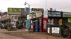
Commercial area along US 285 in Pine Junction
USA Colorado location map.svg
Red pog.svg
Pine Junction
Usa edcp location map.svg
Red pog.svg
Pine Junction
Coordinates: 39°27′58″N105°23′45″W / 39.46611°N 105.39583°W / 39.46611; -105.39583
Country Flag of the United States.svg  United States
State Flag of Colorado.svg  Colorado
Counties Park, Jefferson
Elevation
[1]
8,448 ft (2,575 m)
Time zone UTC-7 (MST)
  Summer (DST) UTC-6 (MDT)
Highways US 285.svg US 285

Pine Junction is a small unincorporated community in central Colorado in the United States. Pine Junction is the first intersection with a traffic light on U.S. Highway 285 in the foothills. At this traffic light, you can turn left on Colorado Rd 126 to go to the historic Town of Pine Grove and continue to State Highway 67 to Deckers and Woodland Park.

Pine Junction is situated in the foothills of the Front Range south of Mount Blue Sky, approximately 25 miles (40 km) southwest of Denver along U.S. Highway 285. The community sits astride the Park-Jefferson county line, and is situated at the crest of a hill on the highway, east of where the highway drops from Crow Hill down into the Platte Canyon near Bailey. The community consists of a strip of retail businesses along the highway, as well as nearby houses on either side of highway. It serves partially as a bedroom community for the Denver Metropolitan Area to the northeast. It is also home to a large array of other commercial ventures such as, a hardware store, and a storage rental.

Pine Junction is part of Colorado's Bustang network. It is on the Gunnison-Denver Outrider line. [2]

39°28′29.74″N105°22′17.72″W / 39.4749278°N 105.3715889°W / 39.4749278; -105.3715889

Related Research Articles

<span class="mw-page-title-main">Douglas County, Colorado</span> County in Colorado, United States

Douglas County is a county located in the U.S. state of Colorado. As of the 2020 Census, the population was 357,978. The county is named in honor of U.S. Senator Stephen A. Douglas. The county seat is Castle Rock.

<span class="mw-page-title-main">Alamosa, Colorado</span> City in Colorado, United States

Alamosa is a home rule municipality and the county seat of Alamosa County, Colorado, United States. The city population was 9,806 in the 2020 United States Census. The city is the commercial center of the San Luis Valley in south-central Colorado, and is the home of Adams State University.

<span class="mw-page-title-main">Park County, Colorado</span> County in Colorado, United States

Park County is a county located in the U.S. state of Colorado. As of the 2020 census, the population was 17,390. The county seat is Fairplay. The county was named after the large geographic region known as South Park, which was named by early fur traders and trappers in the area.

<span class="mw-page-title-main">Mesa County, Colorado</span> County in Colorado, United States

Mesa County is a county located in the U.S. state of Colorado. As of the 2020 census, the population was 155,703. The county seat and most populous municipality is Grand Junction. The county was named for the many large mesas in the area, including the Grand Mesa, which is the largest flat-topped mountain in the world.

<span class="mw-page-title-main">Jefferson County, Colorado</span> County in Colorado, United States

Jefferson County is a county located in the U.S. state of Colorado. As of the 2020 census, the population was 582,910, making it the fourth-most populous county in Colorado. The county seat is Golden, and the most populous city is Lakewood.

<span class="mw-page-title-main">Westminster, Colorado</span> City in Colorado, United States

The City of Westminster is a home rule municipality located in Adams and Jefferson counties, Colorado, United States. The city population was 116,317 at the 2020 United States Census with 71,240 residing in Adams County and 45,077 residing in Jefferson County. Westminster is the eighth most populous city in Colorado. The city is a part of the Denver–Aurora–Lakewood, CO Metropolitan Statistical Area and the Front Range Urban Corridor. The Westminster Municipal Center is located 9 miles (14 km) north-northwest of the Colorado State Capitol in Denver.

<span class="mw-page-title-main">Delta, Colorado</span> City in Colorado, United States

Delta is a home rule municipality that is the county seat and the most populous municipality of Delta County, Colorado, United States. The town population was 9,035 at the 2020 United States Census. The United States Forest Service headquarters of the Grand Mesa, Gunnison, and Uncompahgre National Forests are located in Delta.

<span class="mw-page-title-main">Rico, Colorado</span> Town in Colorado, United States

Rico is a town in Dolores County, Colorado, United States. It was settled in 1879 as a silver mining center in the Pioneer Mining District; today it functions as a historic and tourism site. The population was 288 at the 2020 census. Its current form of government is that of a home rule municipality.

<span class="mw-page-title-main">Monument, Colorado</span> Town in Colorado, United States

Monument is a home rule town situated at the base of the Rampart Range in El Paso County, Colorado, United States. Monument is one of the three communities that make up the Tri-Lakes area, along with Palmer Lake and Woodmoor. The town is part of the Colorado Springs metropolitan area, which had an estimated population of 700,000 in 2019. Monument is bordered by Pike National Forest on the west, Colorado Springs and the United States Air Force Academy to the south, Bald Mountain, True Mountain, and Spruce Mountain to the north, and Black Forest and rolling plains to the east. Monument was first settled as a stop along the Rio Grande Railroad in 1872, and the area was incorporated as a town called Henry's Station in 1879, but the name was later changed to Monument. The town population was 10,399 at the 2020 United States Census, an increase from the population of 5,530 in 2010 and 1,971 in 2000. On April 1, 2019, the town declared itself to be a Second Amendment sanctuary.

<span class="mw-page-title-main">Cañon City, Colorado</span> Home rule municipality in Colorado, United States

Cañon City is a home rule municipality that is the county seat and the most populous municipality of Fremont County, Colorado, United States. The city population was 17,141 at the 2020 United States Census. Cañon City is the principal city of the Cañon City, CO Micropolitan Statistical Area and is a part of the Front Range Urban Corridor. Cañon City straddles the easterly flowing Arkansas River and is a popular tourist destination for sightseeing, whitewater rafting, and rock climbing. The city is known for its many public parks, fossil discoveries, Skyline Drive, The Royal Gorge railroad, the Royal Gorge, and extensive natural hiking paths. In 1994, the United States Board on Geographic Names approved adding the tilde to the official name of Cañon City, a change from Canon City as the official name in its decisions of 1906 and 1975. It is one of the few U.S. cities to have the Spanish Ñ in its name, others being La Cañada Flintridge, California; Española, New Mexico; Peñasco, New Mexico; and Peñitas, Texas.

<span class="mw-page-title-main">Fairplay, Colorado</span> Town in Park County, Colorado, United States

Fairplay is the Statutory Town that is the county seat and the most populous municipality of Park County, Colorado, United States. The town population was 724 at the 2020 United States Census. Fairplay is located in South Park at an elevation of 9,953 feet (3,034 m). The town is the fifth-highest incorporated place in the State of Colorado. Fairplay is now a part of the Denver–Aurora–Lakewood, CO Metropolitan Statistical Area and the Front Range Urban Corridor.

<span class="mw-page-title-main">U.S. Route 285</span> North–south highway through the US states of Texas, New Mexico and Colorado

U.S. Route 285 is a north–south United States highway, running 846 miles (1,362 km) through the states of Texas, New Mexico and Colorado. The highway's southern terminus is in Sanderson, Texas at an intersection with U.S. Route 90. US 285 has always had an endpoint in Denver, Colorado, although the original US 285 went north from Denver. Today the highway's northern terminus is in Denver, at exit 201 on Interstate 25.

<span class="mw-page-title-main">Conifer, Colorado</span> Unincorporated community in Colorado, United States

Conifer is an unincorporated community in Jefferson County, Colorado, United States. Conifer is located along U.S. Route 285 in the foothills west of Denver.

<span class="mw-page-title-main">Red Hill Pass (Colorado)</span>

Red Hill Pass is a high mountain pass in the Rocky Mountains of central Colorado in the United States.

<span class="mw-page-title-main">Grant, Colorado</span> Unincorporated community in Park County, Colorado, United States

Grant is an unincorporated community and a U.S. Post Office in Park County, Colorado, United States.

<span class="mw-page-title-main">Jefferson, Colorado</span> Unincorporated community in Park County, Colorado, United States

Jefferson is an unincorporated community in Park County, Colorado, United States.

Note: A fully interactive online map of the Lincoln Highway and all of its re-alignments, markers, monuments and historic points of interest can be viewed at the Lincoln Highway Association Official Map website.

<span class="mw-page-title-main">Antero Junction, Colorado</span>

Antero Junction is an extinct town located in Park County, Colorado, United States. The townsite is located at 38.9233°N 105.9653°W at an elevation of 9,187 feet. Antero Junction is located at the junction of U.S. Route 285 and U.S. Route 24.

<span class="mw-page-title-main">Lakewood, Colorado</span> City in Colorado, United States

Lakewood is the home rule municipality that is the most populous municipality in Jefferson County, Colorado, United States. The city population was 155,984 at the 2020 U.S. Census, making Lakewood the fifth most populous city in Colorado and the 167th most populous city in the United States. Lakewood is a suburb of Denver and is a principal city of the Denver–Aurora–Lakewood, CO Metropolitan Statistical Area and a major city of the Front Range Urban Corridor.

<span class="mw-page-title-main">Bustang</span> Public intercity bus service in Colorado

Bustang is an intercity bus service in the U.S. state of Colorado. Service began in 2015 and originally traveled between Denver and Colorado Springs, Fort Collins, and Glenwood Springs. Service has since been expanded to connect Grand Junction, Durango, Gunnison, Alamosa, Pueblo, Fairplay and Lamar among others. It is Colorado's first state-run bus service. In 2022, the system had a ridership of 90,600, or about 1,800 per weekday as of the second quarter of 2023.

References

  1. "US Board on Geographic Names". United States Geological Survey. October 25, 2007. Retrieved January 31, 2008.
  2. "Bustang Schedule". RideBustang. CDOT.