Dakota Ridge, Colorado

Last updated

Dakota Ridge, Colorado
Ridge Trail access 2017-09-30 1712.jpg
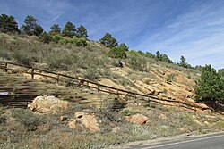
Dakota Ridge trail access
Jefferson County Colorado Incorporated and Unincorporated areas Dakota Ridge Highlighted 0819150.svg
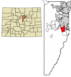
Location of the Dakota Ridge CDP in Jefferson County, Colorado.
Usa edcp location map.svg
Red pog.svg
Dakota Ridge
Location of the Dakota Ridge CDP, Colorado.
USA Colorado location map.svg
Red pog.svg
Dakota Ridge
Dakota Ridge (Colorado)
Coordinates: 39°37′09″N105°08′03″W / 39.6192°N 105.1343°W / 39.6192; -105.1343 (Dakota Ridge, Colorado) [1]
Country United States
State Colorado
County Jefferson [2]
Government
  Type unincorporated community
  Body Jefferson County [2]
Area
[3]
  Total
9.685 sq mi (25.085 km2)
  Land9.387 sq mi (24.311 km2)
  Water0.299 sq mi (0.774 km2)
Elevation
[1]
5,768 ft (1,758 m)
Population
 (2020) [4]
  Total
33,892
  Density3,610.7/sq mi (1,394.1/km2)
Time zone UTC−07:00 (MST)
  Summer (DST) UTC−06:00 (MDT)
ZIP codes [5]
Littleton 80127
Morrison 80465
Area codes 303/720/983
GNIS CDP ID 2583230
FIPS code 08-19150

Dakota Ridge is an unincorporated community and a census-designated place (CDP) located in and governed by Jefferson County, Colorado, United States. The CDP is a part of the Denver-Aurora-Centennial, CO Metropolitan Statistical Area. The population of the Dakota Ridge CDP was 33,892 at the United States Census 2020. [4] In 1988, voters turned down a proposal to incorporate Dakota Ridge. [6] The community lies in ZIP codes 80127 and 80465. [5]

Contents

Geography

Dakota Ridge is bordered to the east by Denver, to the north by Lakewood, and to the south by unincorporated Ken Caryl. It is bordered to the west by the Dakota Hogback, a sharp hogback ridge that to the north near Morrison is also known as Dinosaur Ridge.

Colorado State Highway 470, part of the beltway around the Denver metropolitan area, runs through the western part of the community, leading north to Golden and southeast to Highlands Ranch. Downtown Denver is 17 miles (27 km) to the northeast.

The Dakota Ridge CDP has an area of 6,199 acres (25.085 km2), including 191 acres (0.774 km2) of water. [3]

Demographics

The United States Census Bureau initially defined the Dakota Ridge CDP for the United States Census 2010.

Dakota Ridge CDP, Colorado
YearPop.±%
2010 32,005    
2020 33,892+5.9%
Source: United States Census Bureau

Education

Dakota Ridge is served by the Jefferson County Public Schools.

See also

References

  1. 1 2 "Dakota Ridge, Colorado". Geographic Names Information System . United States Geological Survey, United States Department of the Interior . Retrieved September 27, 2025.
  2. 1 2 "Colorado Counties". Colorado Department of Local Affairs . Retrieved September 27, 2025.
  3. 1 2 "State of Colorado Census Designated Places - BAS20 - Data as of January 1, 2020". United States Census Bureau . Retrieved December 17, 2020.
  4. 1 2 United States Census Bureau. "Dakota Ridge CDP, Colorado" . Retrieved April 15, 2023.
  5. 1 2 "ZIP Code Lookup". United States Postal Service . Retrieved September 27, 2025.
  6. "Western History Subject Index". digital.denverlibrary.org. Retrieved January 12, 2021.