Columbine, Colorado

Last updated

Columbine, Colorado
Jefferson County Colorado Incorporated and Unincorporated areas Columbine Highlighted.svg
Location of the Columbine CDP in Jefferson and Arapahoe counties, Colorado.
Usa edcp location map.svg
Red pog.svg
Columbine
Location of the Columbine CDP in the United States.
Coordinates: 39°35′16″N105°04′10″W / 39.5878649°N 105.0693791°W / 39.5878649; -105.0693791 (Columbine CDP, Colorado) [1]
Country Flag of the United States.svg  United States
State Flag of Colorado.svg  Colorado
Counties Jefferson & Arapahoe
Government
[2]
  Type unincorporated community
Area
[1]
  Total6.753 sq mi (17.491 km2)
  Land6.631 sq mi (17.173 km2)
  Water0.123 sq mi (0.318 km2)
Elevation
[2]
5,545 ft (1,690 m)
Population
 (2020) [3]
  Total25,229
  Density3,700/sq mi (1,400/km2)
Time zone UTC-7 (MST)
  Summer (DST) UTC-6 (MDT)
ZIP Code [4]
80123
Area codes 303 & 720

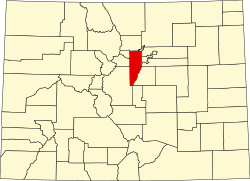
Columbine is a census-designated place (CDP) in and governed by Jefferson and Arapahoe counties in Colorado, United States. [5] The CDP is a part of the Denver metropolitan area. Located primarily in Jefferson County, Columbine lies immediately south of Denver. The population of the Columbine CDP was 25,229 at the 2020 census. [3] The community lies in ZIP code 80123. [6]

Contents

History

Columbine High School sign, August 2008 Columbine High School sign.jpg
Columbine High School sign, August 2008

Columbine grew rapidly during the Space Race years from 1958 to 1968 with the construction of the Martin Company missile facility in Waterton Canyon. Its population exceeded 20,000 for the first time in 1980.

Columbine was the site of the Columbine High School massacre in 1999 perpetrated by Eric Harris and Dylan Klebold.

Geography

Columbine is located on the eastern edge of Jefferson County with a small portion extending east into Arapahoe County. Columbine is bordered to the east by Littleton and Columbine Valley, and to the west by Ken Caryl. The Denver city limits are 0.3 miles (0.48 km) north of the northern border of Columbine, and to the south the community extends as far as the Chatfield Reservoir dam.

The Columbine CDP has an area of 4,322 acres (17.491 km2), including 79 acres (0.318 km2) of water. [1]

Demographics

The United States Census Bureau initially defined the Columbine CDP for the 1980 United States Census.

Columbine CDP, Colorado
YearPop.±%
1980 23,523    
1990 23,969+1.9%
2000 24,095+0.5%
2010 24,280+0.8%
2020 25,229+3.9%
Source: United States Census Bureau

Education

The portion of Columbine in Jefferson County is served by the Jefferson County Public Schools. [7]

The portion of Columbine in Arapahoe County is served by the Littleton Public Schools. [17] This section is zoned to:

Jefferson County Public Library operates the Columbine Library. It opened in 1989, and an expansion and renovation were completed in 2017. [21]

See also

Related Research Articles

<span class="mw-page-title-main">Denver metropolitan area</span> Metropolitan Statistical Area in Colorado, United States

Denver is the central city of a conurbation region in the U.S. state of Colorado. The conurbation includes one continuous region consisting of the six central counties of Adams, Arapahoe, Broomfield, Denver, Douglas, and Jefferson. The Denver region is part of the Front Range Urban Corridor and its metropolitan planning organization is the Denver Regional Council of Governments.

<span class="mw-page-title-main">Jefferson County, Colorado</span> County in Colorado, United States

Jefferson County is a county located in the U.S. state of Colorado. As of the 2020 census, the population was 582,910, making it the fourth-most populous county in Colorado. The county seat is Golden, and the most populous city's Lakewood.

<span class="mw-page-title-main">Arapahoe County, Colorado</span> County in Colorado, United States

Arapahoe County is a county located in the U.S. state of Colorado. As of the 2020 census, its population was 655,070, making it the third-most populous county in Colorado. The county seat is Littleton, and the most populous city is Aurora. The county was named for the Arapaho Native American tribe, who once lived in the region.

<span class="mw-page-title-main">Bow Mar, Colorado</span> Town in Colorado, United States

Bow Mar is a Statutory Town located in Arapahoe and Jefferson counties, Colorado, United States. The town population was 853 at the 2020 United States Census with 587 residing in Arapahoe County and 266 residing in Jefferson County. Bow Mar is part of the Front Range Urban Corridor. The current mayor of Bow Mar is Bryan Sperry.

<span class="mw-page-title-main">Highlands Ranch, Colorado</span> Census Designated Place in Colorado, United States

Highlands Ranch is an unincorporated community and a census-designated place (CDP) located in and governed by Douglas County, Colorado, United States. The CDP is a part of the Denver–Aurora–Lakewood, CO Metropolitan Statistical Area. The population of the Highlands Ranch CDP was 105,631 at the 2020 census, making it the most populous unincorporated community in the State of Colorado. The Highlands Ranch Metropolitan District provides services to the community, which lies in ZIP Codes 80126, 80129, 80130, and 80163.

<span class="mw-page-title-main">Applewood, Colorado</span> Census Designated Place in Colorado, United States

Applewood is an unincorporated community and a census-designated place (CDP) located in and governed by Jefferson County, Colorado, United States. The CDP is a part of the Denver–Aurora–Lakewood, CO Metropolitan Statistical Area. The population of the Applewood CDP was 7,833 at the 2020 United States Census. The Golden post office serves the area.

<span class="mw-page-title-main">Evergreen, Colorado</span> Census Designated Place in Colorado, United States

Evergreen is an unincorporated town, a post office, and a census-designated place (CDP) located in and governed by Jefferson County, Colorado, U.S. The CDP is a part of the Denver–Aurora–Lakewood, CO Metropolitan Statistical Area. The Evergreen post office has the ZIP Codes 80439 and 80437. At the 2020 census, the population of the Evergreen CDP was 9,307. The Evergreen Metropolitan District provides services.

<span class="mw-page-title-main">Ken Caryl, Colorado</span> Census Designated Place in Colorado, United States

Ken Caryl, commonly known as Ken Caryl Ranch, is an unincorporated community and a census-designated place (CDP) located in and governed by Jefferson County, Colorado, United States. The CDP is a part of the Denver–Aurora–Lakewood, CO Metropolitan Statistical Area. The population of the Ken Caryl CDP was 33,811 at the 2020 census. The Ken Caryl Ranch Metropolitan District and the Ken Caryl Ranch Water District provide services. The Littleton post office serves the area.

Estelle is a census-designated place (CDP) in Jefferson Parish, Louisiana, United States. The population was 17,952 in 2020. It is part of the New Orleans–Metairie–Kenner metropolitan statistical area.

<span class="mw-page-title-main">West Pleasant View, Colorado</span> Census Designated Place in Colorado, United States

West Pleasant View is an unincorporated community and a census-designated place (CDP) located in and governed by Jefferson County, Colorado, United States. The CDP is a part of the Denver–Aurora–Lakewood, CO Metropolitan Statistical Area. The population of the West Pleasant View CDP was 4,327 at the United States Census 2020. The Pleasant View Metropolitan District provides services. The Golden post office serves the area.

<span class="mw-page-title-main">Columbine High School</span> Public high school in Columbine, Colorado, United States

Columbine High School (CHS) is a public high school in Columbine, Colorado, United States, in the Denver metropolitan area. It is part of the Jefferson County Public Schools district.

Chatfield High School is a high school located in Ken Caryl, an unincorporated area of Jefferson County near Littleton, Colorado, United States. It is part of the Jefferson County Public Schools system.

<span class="mw-page-title-main">Jefferson County Public Schools (Colorado)</span> School district in Jefferson County, Colorado

Jefferson County School District R-1 is a school district in Jefferson County, Colorado. The district is headquartered at the Jeffco Public Schools Education Center in an unincorporated area of the county near Golden in the Denver metropolitan area. Jeffco Public Schools serves almost 81,000 students in 166 schools. It is the second-largest school district in Colorado, having been surpassed in 2013 by Denver Public Schools, which has an enrollment of approximately 81,000.

<span class="mw-page-title-main">Colorado's 6th congressional district</span> U.S. House district for Colorado

Colorado's 6th congressional district is a congressional district in the U.S. state of Colorado. Located in central Colorado, the district encompasses much of the eastern part of the Denver metropolitan area, including all of Aurora, as well as portions of the southern and northern metro area.

<span class="mw-page-title-main">Littleton, Colorado</span> City in Colorado, United States

Littleton is a home rule municipality city located in Arapahoe, Douglas, and Jefferson counties, Colorado, United States. Littleton is the county seat of Arapahoe County and is a part of the Denver–Aurora–Lakewood, CO Metropolitan Statistical Area. The city population was 45,652 at the 2020 United States Census, ranking as the 20th most populous municipality in Colorado.

<span class="mw-page-title-main">Littleton Public Schools</span> School district in Colorado, United States

The Arapahoe County School District No. 6, more commonly known as Littleton Public Schools (LPS), is a school district in Littleton, Colorado which serves several communities within the southern Denver metropolitan area. It is governed by a five-member Board of Education, and administered by a superintendent and six executives. Its headquarters, the Education Services Center, is located in Downtown Littleton. It is the fifteenth largest school district in Colorado. LPS operates 11 elementary schools, four middle schools, three high schools, several alternative programs, a preschool, and two charter schools.

<span class="mw-page-title-main">Heritage High School (Littleton, Colorado)</span> Public school in Colorado, United States

Heritage High School is a public school located in Littleton, Colorado, United States. It was established in 1972 as the last of three high schools in the Littleton Public Schools system. It was rated by Newsweek magazine as one of the top 200 high schools in the US in 2010, and the Denver-based 5280 magazine acknowledged Heritage High School as one of the best schools in the Denver area. The school colors are scarlet and silver. The mascot is the bald eagle.

<span class="mw-page-title-main">Clement Park</span> Park in Jefferson County, Colorado, U.S.

Robert F. Clement Park is located in Columbine, unincorporated Jefferson County, Colorado. It is part of the Foothills Park and Recreation District.

<span class="mw-page-title-main">Englewood Schools</span> School district in Englewood, Colorado

Englewood Schools is a school district located in Englewood, Colorado, United States, in the Greater Denver area.

<span class="mw-page-title-main">Columbine Memorial</span> Memorial in Colorado commemorating the Columbine High School Massacre

The Columbine Memorial is a memorial in Columbine, Colorado, that honors the deceased and injured victims, survivors, rescuers, and all who were affected by the Columbine High School massacre on April 20, 1999. The memorial is located in Clement Park, which is behind Columbine High School, the site of the massacre. It is operated by a non-profit institution whose mission is to operate the memorial and its upkeeping.

References

  1. 1 2 3 "State of Colorado Census Designated Places - BAS20 - Data as of January 1, 2020". United States Census Bureau . Retrieved December 17, 2020.
  2. 1 2 "U.S. Board on Geographic Names: Domestic Names". United States Geological Survey . Retrieved December 17, 2020.
  3. 1 2 United States Census Bureau. "Columbine CDP, Colorado" . Retrieved April 10, 2023.
  4. "Zip Code 80123 Map and Profile". zipdatamaps.com. 2020. Retrieved December 20, 2020.
  5. "2020 CENSUS - CENSUS BLOCK MAP: Columbine CDP, CO" (PDF). U.S. Census Bureau . Retrieved July 24, 2024.
  6. "Look Up a ZIP Code". United States Postal Service . Retrieved December 17, 2020.
  7. "2020 CENSUS - SCHOOL DISTRICT REFERENCE MAP: Jefferson County, CO" (PDF). U.S. Census Bureau. p. 1 (PDF p. 2/3). Retrieved January 28, 2023. - Text list - 2010 map
  8. "Elementary School Boundaries". Jefferson County Public Schools (Colorado) . Retrieved July 25, 2024.
  9. "Columbine Hills Elementary". Jefferson County Public Schools . Retrieved July 25, 2024.
  10. "Dutch Creek Elementary". Jefferson County Public Schools . Retrieved July 25, 2024.
  11. "Leawood Elementary". Jefferson County Public Schools . Retrieved July 25, 2024.
  12. "Normandy Elementary". Jefferson County Public Schools . Retrieved July 25, 2024.
  13. "Middle School Boundaries". Jefferson County Public Schools (Colorado) . Retrieved July 24, 2024.
  14. "Ken Caryl Middle". Jefferson County Public Schools . Retrieved July 25, 2024.
  15. "High School Boundaries". Jefferson County Public Schools (Colorado) . Retrieved July 24, 2024.
  16. "Columbine High". Jefferson County Public Schools . Retrieved July 25, 2024.
  17. "2020 CENSUS - SCHOOL DISTRICT REFERENCE MAP: Arapahoe County, CO" (PDF). U.S. Census Bureau. p. 1 (PDF p. 2/6). Retrieved January 28, 2023.
  18. "Elementary Boundary Map 23-34" (PDF). Littleton Public Schools . Retrieved July 24, 2024.
  19. "Middle School Boundary Map 2022-2023" (PDF). Littleton Public Schools . Retrieved July 24, 2024.
  20. "High School Boundary Map 2022-2023" (PDF). Littleton Public Schools . Retrieved July 24, 2024.
  21. "Columbine Library". Jefferson County Public Library . Retrieved February 10, 2024.