Pinetops, North Carolina

Last updated

Pinetops, North Carolina
WelcomeSign-PinetopsNC.jpg
Edgecombe County North Carolina incorporated and unincorporated areas Pinetops highlighted.svg
Location in Edgecombe County and the state of North Carolina.
Coordinates: 35°47′28″N77°38′16″W / 35.79111°N 77.63778°W / 35.79111; -77.63778
Country United States
State North Carolina
County Edgecombe
Area
[1]
  Total1.03 sq mi (2.66 km2)
  Land1.03 sq mi (2.66 km2)
  Water0.00 sq mi (0.00 km2)
Elevation
[2]
105 ft (32 m)
Population
 (2020)
  Total1,200
  Density1,169.59/sq mi (451.72/km2)
Time zone UTC-5 (Eastern (EST))
  Summer (DST) UTC-4 (EDT)
ZIP code
27864
Area code 252
FIPS code 37-52140 [3]
GNIS feature ID2407122 [2]
Website townofpinetopsnc.com

Pinetops is a town in Edgecombe County, North Carolina, United States. It is part of the Rocky Mount, North Carolina Metropolitan Statistical Area. The population was 1,374 at the 2010 census.

Contents

History

The historic plantation house of Vinedale was listed on the National Register of Historic Places in 1982. [4] Another historic plantation house, Adelphia, is located near Pinetops.

Geography

According to the United States Census Bureau, the town has a total area of 1.0 square mile (2.6 km2), all land.

Demographics

Historical population
CensusPop.Note
1910 211
1920 465120.4%
1930 60329.7%
1940 71318.2%
1950 1,03144.6%
1960 1,37233.1%
1970 1,3790.5%
1980 1,4656.2%
1990 1,5143.3%
2000 1,419−6.3%
2010 1,374−3.2%
2020 1,200−12.7%
U.S. Decennial Census [5]

2020 census

Pinetops racial composition [6]
RaceNumberPercentage
White (non-Hispanic)41334.42%
Black or African American (non-Hispanic)74962.42%
Other/Mixed 151.25%
Hispanic or Latino 231.92%

As of the 2020 United States census, there were 1,200 people, 567 households, and 391 families residing in the town.

2000 census

As of the census [3] of 2000, there were 1,419 people, 557 households, and 391 families residing in the town. The population density was 1,415.0 inhabitants per square mile (546.3/km2). There were 602 housing units at an average density of 600.3 per square mile (231.8/km2). The racial makeup of the town was 42.21% White, 57.15% African American, 0.07% Native American, 0.21% from other races, and 0.35% from two or more races. Hispanic or Latino of any race were 1.34% of the population.

Located in the heart of eastern North Carolina; Pinetops is on the Raleigh-Greenville Corridor, located centrally between Greenville, Wilson and Rocky Mount. Pinetops offers a wonderful quality of life, with a three campus school system, a variety of businesses, churches and friendly people.

There were 557 households, out of which 29.8% had children under the age of 18 living with them, 43.4% were married couples living together, 22.3% had a female householder with no husband present, and 29.8% were non-families. 27.1% of all households were made up of individuals, and 14.4% had someone living alone who was 65 years of age or older. The average household size was 2.55 and the average family size was 3.07.

In the town, the population was spread out, with 25.2% under the age of 18, 7.6% from 18 to 24, 25.2% from 25 to 44, 26.4% from 45 to 64, and 15.6% who were 65 years of age or older. The median age was 40 years. For every 100 females, there were 81.5 males. For every 100 females age 18 and over, there were 75.8 males.

The median income for a household in the town was $29,716, and the median income for a family was $36,544. Males had a median income of $29,688 versus $23,224 for females. The per capita income for the town was $15,763. About 17.6% of families and 20.8% of the population were below the poverty line, including 31.9% of those under age 18 and 21.3% of those age 65 or over.

Related Research Articles

<span class="mw-page-title-main">Pinetop-Lakeside, Arizona</span> Town in Navajo County, Arizona

Pinetop–Lakeside is a town in Navajo County, Arizona, United States. According to 2020 census, the population of the town is 4,557. It was founded in 1984 when the neighboring towns of Pinetop and Lakeside merged.

<span class="mw-page-title-main">Pollocksville, North Carolina</span> Town in North Carolina, United States

Pollocksville is a town in Jones County, North Carolina, United States. The population was 268 at the 2020 census. It is part of the New Bern, North Carolina Micropolitan Statistical Area. It is situated on US 17 and Highway 58.

<span class="mw-page-title-main">Woodland, North Carolina</span> Town in North Carolina, United States

Woodland is a town in Northampton County, North Carolina, United States. The population was 809 at the 2010 census. It is part of the Roanoke Rapids, North Carolina Micropolitan Statistical Area.

<span class="mw-page-title-main">Bethel, North Carolina</span> Town in North Carolina, United States

Bethel is a town in Pitt County, North Carolina, United States. The population was 1,577 at the 2010 census. The town is a part of the Greenville Metropolitan Area located in North Carolina's Inner Banks region. Confusingly, there are three other towns in the state named "Bethel." One is between Edenton and Hertford in the "Finger Counties" region in the northeastern corner of the state, another is in the north-central part, in Caswell County and the third is located in the Mountain Region of North Carolina, in Haywood County. There is also a community named Bethel located in Watauga County.

<span class="mw-page-title-main">Falkland, North Carolina</span> Town in North Carolina, United States

Falkland is a town in Pitt County, North Carolina, United States. The population was 96 at the 2010 census, making it the least populous town in Pitt County. The town is a part of the Greenville Metropolitan Area located in North Carolina's Inner Banks region.

<span class="mw-page-title-main">Fountain, North Carolina</span> Town in North Carolina, United States

Fountain is a town in Pitt County, North Carolina, United States. The population was 427 at the 2010 census. The town is a part of the Greenville Metropolitan Area located in North Carolina's Inner Banks region.

<span class="mw-page-title-main">Grimesland, North Carolina</span> Town in North Carolina, United States

Grimesland is a town in Pitt County, North Carolina, United States. The population was 441 at the 2010 census. The town is a part of the Greenville Metropolitan Area located in North Carolina's Inner Banks.

<span class="mw-page-title-main">Winterville, North Carolina</span> Town in North Carolina, United States

Winterville is a town in Pitt County, North Carolina, United States. The population was 10,591 as of the 2020 census. The town is a part of the Greenville Metropolitan Area.

<span class="mw-page-title-main">Columbus, North Carolina</span> Town in North Carolina, United States

Columbus is a town and the county seat of Polk County, North Carolina, United States. The population was 999 at the 2010 census.

<span class="mw-page-title-main">Creswell, North Carolina</span> Town in North Carolina, United States

Creswell is a town in Washington County, North Carolina, United States. The population was 207 at the 2020 census.

<span class="mw-page-title-main">Donalds, South Carolina</span> Town in South Carolina, United States

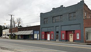
Donalds is a town in Abbeville County, South Carolina. As of the 2020 United States Census, its population was 328.

<span class="mw-page-title-main">Pendleton, South Carolina</span> Town in South Carolina, United States

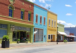
Pendleton is a town in Anderson County, South Carolina, United States. The population was 3,489 at the 2020 census. It is a sister city of Stornoway in the Outer Hebrides of Scotland.

<span class="mw-page-title-main">Berea, South Carolina</span> CDP in South Carolina, United States

Berea is a census-designated place (CDP) in Greenville County, South Carolina, United States. The population was 14,295 at the 2010 census. It is part of the Greenville–Mauldin–Easley Metropolitan Statistical Area.

<span class="mw-page-title-main">City View, South Carolina</span> Census-designated place in South Carolina, United States

City View, a former incorporated city, is now a census-designated place (CDP) in Greenville County, South Carolina, United States. The population was 1,345 at the 2010 census, up from 1,254 in 2000. It is part of the Greenville–Mauldin–Easley Metropolitan Statistical Area.

<span class="mw-page-title-main">Mauldin, South Carolina</span> City in South Carolina, United States

Mauldin is a city in Greenville County, South Carolina, United States. The population was 24,724 at the 2020 census, making it the 19th-most populous city in South Carolina. It is located in the Greenville-Anderson-Greer, SC Metropolitan Statistical Area.

<span class="mw-page-title-main">Taylors, South Carolina</span> CDP in South Carolina, United States

Taylors is a census-designated place (CDP) in Greenville County, South Carolina, United States. The population was 23,222 at the 2020 census. It is part of the Greenville–Mauldin–Easley Metropolitan Statistical Area.

<span class="mw-page-title-main">Elloree, South Carolina</span> Town in South Carolina, United States

Elloree is a town in Orangeburg County, South Carolina, United States. The population was 692 at the 2010 census.

<span class="mw-page-title-main">Holly Hill, South Carolina</span> Town in South Carolina, United States

Holly Hill is a town in Orangeburg County, South Carolina, United States. The population was 1,277 at the 2010 census. Prior to 1910 it was located in the northwest portion of Saint James Goose Creek Township.

<span class="mw-page-title-main">Saluda, South Carolina</span> Town in South Carolina, United States

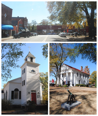
Saluda is a town in Saluda County, South Carolina, United States, along the Little Saluda River. The population was 3,565 at the 2010 census. It is the county seat of Saluda County.

<span class="mw-page-title-main">Pinewood, South Carolina</span> Town in South Carolina, United States

Pinewood is a town located on South Carolina Highway 261 at the southern entrance to the High Hills of Santee in Sumter County, South Carolina, United States. The population was 538 at the 2010 census. It is included in the Sumter, South Carolina Metropolitan Statistical Area.

References

  1. "ArcGIS REST Services Directory". United States Census Bureau. Retrieved September 20, 2022.
  2. 1 2 U.S. Geological Survey Geographic Names Information System: Pinetops, North Carolina
  3. 1 2 "U.S. Census website". United States Census Bureau . Retrieved January 31, 2008.
  4. "National Register Information System". National Register of Historic Places . National Park Service. July 9, 2010.
  5. "Census of Population and Housing". Census.gov. Retrieved June 4, 2015.
  6. "Explore Census Data". data.census.gov. Retrieved December 24, 2021.