
The Potomac River is a major river in the Mid-Atlantic region of the United States that flows from the Potomac Highlands in West Virginia to the Chesapeake Bay in Maryland. It is 405 miles (652 km) long, with a drainage area of 14,700 square miles (38,000 km2), and is the fourth-largest river along the East Coast of the United States and the 21st-largest in the United States. More than 5 million people live within its watershed.

The Youghiogheny River, or the Yough for short, is a 134-mile-long (216 km) tributary of the Monongahela River in West Virginia, Maryland, and Pennsylvania. It drains an area on the west side of the Allegheny Mountains northward into Pennsylvania, providing a small watershed in extreme western Maryland into the tributaries of the Mississippi River. Youghiogheny is a Lenape word meaning "a stream flowing in a contrary direction".

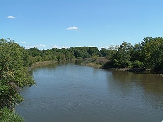
The South Branch Potomac River has its headwaters in northwestern Highland County, Virginia, near Hightown along the eastern edge of the Allegheny Front. After a river distance of 139 miles (224 km), the mouth lies east of Green Spring, Hampshire County, West Virginia, where it meets the North Branch Potomac River to form the Potomac.

The Cacapon River, located in the Appalachian Mountains of West Virginia's Eastern Panhandle region, is an 81.0-mile-long (130.4 km) shallow river known for its fishing, boating, wildlife, hunting, and wilderness scenery. As part of the Potomac River watershed, it is an American Heritage River.

The Little Cacapon River is a 25.1-mile-long (40.4 km) free-flowing tributary of the Potomac River in the center of Hampshire County, West Virginia. Via the Potomac River, its waters are part of the Chesapeake Bay watershed, leading to the Atlantic Ocean. The Little Cacapon enters the Potomac at an elevation of 499 feet (152 m) near the community of Little Cacapon. For the majority of its course the Little Cacapon is a shallow non-navigable stream. It has been historically referred to as both Little Cacapehon and Little Capecaphon. The name is pronounced kə-KAY-pən or KAY-pən.
Back Creek is a 59.5-mile-long (95.8 km) tributary of the Potomac River that flows north from Frederick County, Virginia, to Berkeley County in West Virginia's Eastern Panhandle. Back Creek originates along Frederick County's border with Hampshire County, West Virginia, at Farmer's Gap in the Great North Mountain. Its name reflects its location to the west of North Mountain. The perspective of colonists from the east in the 18th century led them to call it "Back Creek", because it lay to the back of North Mountain.

Catoctin Creek is a 14.1-mile-long (22.7 km) tributary of the Potomac River in Loudoun County, Virginia, with a watershed of 59,000 acres (240 km2). Agricultural lands make up 67 percent and forests 30 percent of Catoctin Creek's watershed. It is the main drainage system for the northern Loudoun Valley, including all of the Catoctin Valley.
Tilhance Creek is a 10.4-mile-long (16.7 km) tributary stream of Back Creek in Berkeley County of West Virginia's Eastern Panhandle.

Goose Creek is a 53.9-mile-long (86.7 km) tributary of the Potomac River in Fauquier and Loudoun counties in northern Virginia. It comprises the principal drainage system for the Loudoun Valley.

The Rio Chama, a major tributary river of the Rio Grande, is located in the U.S. states of Colorado and New Mexico. The river is about 130 miles (210 km) long altogether. From its source to El Vado Dam its length is about 50 miles (80 km), from El Vado Dam to Abiquiu Dam is about 51 miles (82 km), and from Abiquiu Dam to its confluence with the Rio Grande is about 34 miles (55 km).
Between the Hills is a small valley in northwest Loudoun County, Virginia, distinct from, but associated with, the greater Loudoun Valley.

Pohick Creek is a 14.0-mile-long (22.5 km) tributary stream of the Potomac River in Fairfax County in the U.S. state of Virginia. It takes its name from the Pohick Native American tribe once prevalent in the area.

Broad Run is a tributary of the Potomac River in Loudoun County, Virginia. The creek, located between Goose Creek and Sugarland Run, principally drains portions of eastern Loudoun County, as well as a small portion of western Fairfax County.
Big Timber Creek is a 5.6-mile-long (9.0 km) stream in southwestern New Jersey. The creek was called Tetamekanchz Kyl by Lenape tribes prior to European settlement in the area. The creek drains a watershed of 63 square miles (160 km2) and is a tributary of the Delaware River.
Broad Run is a tributary stream of the Potomac River in Montgomery County, Maryland. The headwaters of the stream originate west of the town of Poolesville, and the creek flows southward for 8.9 miles (14.3 km) to the Potomac River. The Broad Run and its watershed are almost entirely within the Montgomery County Agricultural Reserve.

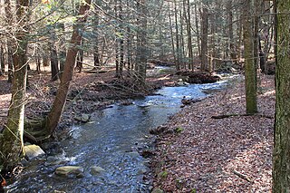
Arnold Creek is a tributary of Huntington Creek in Luzerne County, Pennsylvania, in the United States. It is approximately 5.2 miles (8.4 km) long and flows through Ross Township. The watershed of the creek has an area of 4.72 square miles (12.2 km2) and has no named tributaries, but three unnamed tributaries. The creek is considered to be Class A Wild Trout Waters for its entire length. Brook trout naturally reproduce in it and beech trees occur along it. At least two bridges have been built over the creek, one of which carries Pennsylvania Route 118. A portion of it is in the Pennsylvania State Game Lands Number 206.
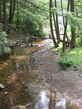
Lick Branch is a tributary of Huntington Creek in Luzerne County, Pennsylvania, in the United States. It is approximately 2.6 miles (4.2 km) long and flows through Ross Township and Fairmount Township. The watershed of the stream has an area of 2.34 square miles (6.1 km2) and has no tributaries. The stream is considered by the Pennsylvania Fish and Boat Commission to be Class A Wild Trout Waters for brook trout throughout its entire length. Glacial till, alluvium, and wetlands can be found in its vicinity.
Halfway Run is a tributary of Rapid Run in Union County, Pennsylvania, in the United States. It is approximately 1.8 miles (2.9 km) long and flows through Hartley Township. The watershed of the stream has an area of 1.51 square miles (3.9 km2). A number of waterlogged pingo scars occur near the stream. The lake is in the vicinity of the Halfway Run Natural Area and R.B. Winter State Park. Numerous tree species inhabit the land near the stream.

Roaring Run is a tributary of Bowman Creek in Wyoming County, Pennsylvania, in the United States. It is approximately 4.9 miles (7.9 km) long and flows through Forkston Township, Noxen Township, and Monroe Township. It has two named tributaries: Newton Run and South Branch Roaring Run. The watershed of Roaring Run has an area of 11.4 square miles (30 km2). It is designated as a High-Quality Coldwater Fishery and a Migratory Fishery and the stream is Class A Wild Trout Waters. The surficial geology in its vicinity consists of alluvium, alluvial terrace, alluvial fan, bedrock, Wisconsinan Till, and Wisconsinan Ice-Contact Stratified Drift. A bridge carrying Pennsylvania Route 29 crosses the stream.
The Potomac River basin reservoir projects were U.S. Army Corps of Engineers programs that sought to regulate the flow of the Potomac River to control flooding, to assure a reliable water supply for Washington, D.C., and to provide recreational opportunities. Beginning in 1921 the Corps studied a variety of proposals for an ambitious program of dam construction on the Potomac and its tributaries, which proposed as many as sixteen major dam and reservoir projects. The most ambitious proposals would have created a nearly continuous chain of reservoirs from tidewater to Cumberland, Maryland. The 1938 program was focused on flood control, on the heels of a major flood in 1936. The reformulated 1963 program focused on water supply and quality, mitigating upstream pollution from sewage and coal mine waste.
