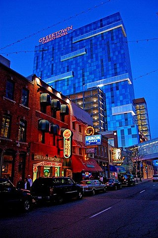
Greektown is a commercial and entertainment district in Detroit, Michigan, located just northeast of the heart of downtown, along Monroe Avenue between Brush and St. Antoine streets. It has a station by that name on the city's elevated downtown transit system known as the Detroit People Mover. Greektown is situated between the Renaissance Center, Comerica Park, and Ford Field.

Massachusetts Avenue is a major diagonal transverse road in Washington, D.C., and the Massachusetts Avenue Historic District is a historic district that includes part of it.

The Neponset Valley Parkway is a historic parkway in southern Boston and Milton, Massachusetts, United States. It is a connecting parkway in the Greater Boston area's network, providing a connection between the Blue Hills Reservation, Neponset River Reservation, and the Stony Brook Reservation. The parkway was constructed between 1898 and 1929 with design assistance from Charles Eliot and the Olmsted Brothers. It was listed on the National Register of Historic Places in 2005.

The Sumner Hill Historic District encompasses a predominantly residential area of high-quality late 19th-century residences in the Jamaica Plain neighborhood of Boston, Massachusetts. It is roughly bounded by Seaverns Avenue, Everett Street, Carolina Avenue, and Newbern Street just east of the neighborhoods commercial Centre Street area. The district features Second Empire, Italianate, and Queen Anne style architecture, and was listed on the National Register of Historic Places in 1987.

The Salem–Auburn Streets Historic District is a residential historic district at Salem and Auburn Streets in Cambridge, Massachusetts. The district includes a collection of houses that is among the oldest in the Cambridgeport section of the city, and includes most of the houses on two blocks of these streets. The district was added to the National Register of Historic Places in 1982.

Passyunk Square is a neighborhood in South Philadelphia bounded by Broad Street to the west, 6th Street to the east, Tasker Street to the south and Washington Avenue to the north. Passyunk Square is bordered by the Bella Vista, Hawthorne, Central South Philadelphia, Wharton, and Point Breeze neighborhoods. The neighborhood got its Lenape name from the 1800s Passyunk Township, Pennsylvania which named Passyunk Square Park, located between 12th, 13th, Reed and Wharton Streets. The park was eventually renamed Columbus Square Park, and subsequently the neighborhood became known as Columbus Square. Sue Montella, Geoff DiMasi, and a group of neighbors revived the Passyunk Square name when forming the Passyunk Square Civic Association in 2003. The name "Passyunk Square" was researched and proposed by Geoff DiMasi after considering other historical names like Wharton that had been used in the neighborhood over the years. The area has come to be known as Little Saigon for its large Vietnamese American commercial and residential presence, with one of the largest Vietnamese populations on the east coast.
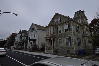
The North Bedford Historic District is a historic district roughly bounded by Summer, Parker, Pleasant and Kempton Streets in New Bedford, Massachusetts. It encompasses a predominantly residential neighborhood north of downtown New Bedford which was developed primarily in the mid 19th-century. It features a variety of worker housing of the period, as well as a number of higher quality houses built by businessmen. The district was added to the National Register of Historic Places in 1979.

The Acushnet Heights Historic District is a predominantly residential historic district in central New Bedford, Massachusetts. It encompasses a densely-built urban area about 20 acres (8.1 ha) in size, which was developed as a working-class area, beginning in the 1860s, for the many workers in the city's factories. The district was listed on the National Register of Historic Places in 1989. It abuts the North Bedford Historic District, which is just to the south, and includes the following separately-listed properties: the Union Street Railway Carbarn, the Bradford Smith Building, and the Dawson Building.

Buttonwood Park Historic District is a historic district on Kempton Street, Rockdale Avenue, Hawthorne Street and Brownell Avenue in New Bedford, Massachusetts. Its focal point is Buttonwood Park, a 97-acre (39 ha) municipal park planned by Charles Eliot in the 1890s, and part of its surrounding neighborhood. The neighborhood was developed in the first decades of the 20th century as a complement to the park, and contains a fine selection of Colonial Revival and Craftsman style houses. The district was added to the National Register of Historic Places in 2000.

The Quadrangle–Mattoon Street Historic District is a historic district in Springfield, Massachusetts, bounded by Chestnut Street to the West; State Street to the South; and includes properties on Mattoon, Salem, Edwards and Elliot Streets. Located in the Metro Center, the Quadrangle–Mattoon Street Historic District is one of the few neighborhoods in the Knowledge Corridor lined with historic, restored red-brick Victorian row houses on both sides, covered by tree canopies.

The Salem Willows Historic District of eastern Salem, Massachusetts encompasses a now residential area that had its origins as a 19th-century summer resort community. Development of the area began in 1875, after Daniel Gardner purchased land at Juniper Point he had been leasing with the intent of developing it. There is evidence from an 1874 map that he may have begun development as early as 1874, even though he did not have permission to erect permanent structures on the land then. This development grew, and a significant number of modest cottage-style houses were built between then and the early 20th century. Alongside this development, the Salem Willows Park, just to its north, began to take shape, with a casino located at Bay View and Fort Avenues, and a large pavilion at Fort and Island Avenues, visible on an 1897 map. The area became popular with day visitors, and hotels catering to tourists were built, although only one, the Central House at 1 High Avenue, has survived but as a private residence. The park is owned by the city, and continues to be used as a recreational area.

The Bridge Street Neck Historic District is a predominantly residential historic district in Salem, Massachusetts. It encompasses most of a peninsula of land northeast of downtown Salem, on the route connecting Salem to Beverly, which has been the scene of residential, commercial, and industrial development since the early settlement of Salem in the 1630s. Bridge Street, the spine of the district is a thoroughfare connecting Salem to the bridge leading to Beverly. The district is roughly bounded by railroad tracks to its west, the shore of the peninsula to the east, On the north it is bounded by modern (post-1952) developments, and on the south it abuts the Salem Common Historic District. In addition to properties on Bridge Street, the district includes properties on side streets between March/Osgood Streets, and Howard/Webb Streets. It was listed on the National Register of Historic Places in 2002.
The Silver Hill Historic District encompasses the first major residential subdivision of Weston, Massachusetts. It includes 79 buildings on Silver Hill and Westland Roads, and Merriam Street. The area of Silver Hill and Westland Roads was formally laid out in 1905, while Merriam Street is a very old country road which had seen some development in the 1890s. The houses in the district are predominantly Colonial Revival and Queen Anne in their styling, a relative rarity in Weston although common in other Boston suburbs. The district was added to the National Register of Historic Places in 2004.

The Common Historic District is a historic district encompassing the civic and institutional heart of Reading, Massachusetts. The district is centered on the town common, at the intersection of Main and Salem Streets. The common has been communally owned since at least 1737, with the original burying ground to the north. In 1769 the area's first meeting house was built, giving the area a sense of identity separate from portions of Reading that would later be set off as Wakefield and North Reading. Since then the area has become a focal point for religious and civic institutions in the town.

The Yale Avenue Historic District is a residential historic district near the center of Wakefield, Massachusetts. It encompasses eight residential properties, all but one of which were developed in the 1860s and 1870s, after the arrival of the railroad in town. These properties were built primarily for Boston businessmen, and mark the start of Wakefield's transition to a suburb.

The House at 18A and 20 Aborn Street in Wakefield, Massachusetts is a historic house and carriage house with elaborate Queen Anne styling. It was built in the mid-1880s, and is one of the most ornate houses in the neighborhood. The property was listed on the National Register of Historic Places in 1989.

College Hill is a residential neighborhood in Easton, Pennsylvania. The neighborhood is situated on the hill overlooking downtown Easton which was once known as Mount Lafayette, and before that, Mount Washington. Lafayette College borders the neighborhood on its southwest side. The northern boundary of the neighborhood is Forks Township. The boundary lies along Chestnut Ridge, a steep hill that rises to 700 feet. College Hill has a total of three historic religious institutional buildings, three parks, and the remains of Rinek Mansion grounds.

The Sherman Hill Historic District is located in Des Moines, Iowa, United States. It is one of the oldest residential neighborhoods in Des Moines. Single-family houses were constructed beginning around 1880 and multi-family dwellings were built between 1900 and 1920. The district encompasses 80 acres (0.32 km2) and 210 buildings and is bounded by 15th Street to the East, High Street to the South, Martin Luther King Parkway on the West, and School Street to the North. The historic district has been listed on the National Register of Historic Places since 1979.

Mount Vernon Triangle is a neighborhood and community improvement district in the northwest quadrant of Washington, D.C. The neighborhood is located adjacent to Mount Vernon Square. Originally a working-class neighborhood established in the 19th century, present-day Mount Vernon Triangle experienced a decline in the mid-20th century as it transitioned from residential to commercial and industrial use.

Fort Hill is a 0.4 square mile neighborhood and historic district of Roxbury, in Boston, Massachusetts. The approximate boundaries of Fort Hill are Malcolm X Boulevard on the north, Washington Street on the southeast, and Columbus Avenue on the southwest.


