Route 45 is a state highway in the southern part of New Jersey, United States. It runs 28.51 mi (45.88 km) from Route 49 in Salem, Salem County, northeast to U.S. Route 130 in Westville, Gloucester County. Much of the southern part of the route runs through rural areas of Salem and Gloucester counties, passing through the communities of Woodstown and Mullica Hill. North of Mullica Hill, Route 45 runs through suburban areas, with the portion of the route between the northern border of Mantua Township and the southern border of Woodbury a four-lane divided highway. The route intersects many highways, including US 40 in Woodstown, Route 77 and US 322 in Mullica Hill, and Interstate 295 (I-295) in West Deptford Township.
Route 48 is an east–west state highway in Salem County in the U.S. state of New Jersey. It is a 4.26-mile (6.86 km) route running from U.S. Route 130 and County Route 675 in Penns Grove to US 40 in Carneys Point Township. It is known as East Main Street from US 130 to DuPont Road, and as the Harding Highway from DuPont Road to its terminus at US 40. Route 48 is signed east–west, although it travels more northwest-southeast throughout its route. It is a two-lane, undivided road through its entire length that intersects with Interstate 295 (I-295) and CR 551.

Alloway Township is a township in Salem County, New Jersey, United States. As of the 2010 United States Census, the township's population was 3,467, reflecting an increase of 693 (+25.0%) from the 2,774 counted in the 2000 Census, which had in turn declined by 21 (-0.8%) from the 2,795 counted in the 1990 Census. What is now Alloway was formally incorporated as Upper Alloways Creek Township by a Royal charter granted on June 17, 1767, from portions of the now-defunct Alloways Creek Township. The township was formally incorporated by an act of the New Jersey Legislature on February 21, 1798. Quinton Township was formed from portions of the township on February 18, 1873. The name was officially changed to Alloway Township as of February 21, 1884.

Carneys Point Township is a township in Salem County, New Jersey, United States. As of the 2010 United States Census, the township's population was 8,049, reflecting an increase of 365 (+4.8%) from the 7,684 counted in the 2000 Census, which had in turn declined by 759 (-9.0%) from the 8,443 counted in the 1990 Census.
Lower Alloways Creek Township is a township in Salem County, in the U.S. state of New Jersey. As of the 2010 United States Census, the township's population was 1,770, reflecting a decline of 81 (-4.4%) from the 1,851 counted in the 2000 Census, which had in turn declined by 7 (-0.4%) from the 1,858 counted in the 1990 Census.

Mannington Township is a township in Salem County, New Jersey, United States. As of the 2010 United States Census, the township's population was 1,806, reflecting an increase of 247 (+15.8%) from the 1,559 counted in the 2000 Census, which had in turn declined by 134 (-7.9%) from the 1,693 counted in the 1990 Census.

Oldmans Township is a township in Salem County, New Jersey, United States. As of the 2010 United States Census, the township's population was 1,773, reflecting a decline of 25 (-1.4%) from the 1,798 counted in the 2000 Census, which had in turn increased by 115 (+6.8%) from the 1,683 counted in the 1990 Census.

Pennsville Township is a township in Salem County, in the U.S. state of New Jersey. As of the 2010 United States Census, the township's population was 13,409, reflecting an increase of 215 (+1.6%) from the 13,194 counted in the 2000 Census, which had in turn declined by 600 (-4.3%) from the 13,794 counted in the 1990 Census. The township is named for William Penn. The township includes the state's westernmost point.

Pilesgrove Township is a township in Salem County, New Jersey, United States. As of the 2010 United States Census, the township's population was 4,016, reflecting an increase of 93 (+2.4%) from the 3,923 counted in the 2000 Census, which had in turn increased by 673 (+20.7%) from the 3,250 counted in the 1990 Census.

Quinton Township is a township in Salem County, in the U.S. state of New Jersey. At the 2010 United States Census, the township's population was 2,666, reflecting a decline of 120 (-4.3%) from the 2,786 counted in the 2000 Census, which had in turn increased by 275 (+11.0%) from the 2,511 counted in the 1990 Census.

Upper Pittsgrove Township is a township in Salem County, New Jersey, United States. As of the 2010 United States Census, the township's population was 3,505, reflecting an increase of 37 (+1.1%) from the 3,468 counted in the 2000 Census, which had in turn increased by 328 (+10.4%) from the 3,140 counted in the 1990 Census.

Woodstown is a borough in Salem County, New Jersey, United States. As of the 2010 United States Census, the borough's population was 3,505, reflecting an increase of 369 (+11.8%) from the 3,136 counted in the 2000 Census, which had in turn declined by 18 (−0.6%) from the 3,154 counted in the 1990 Census.

The Salem River is a 34.7-mile-long (55.8 km) tributary of the Delaware River in southwestern New Jersey in the United States.
County Route 551 is a county highway in the U.S. state of New Jersey. The highway extends 34.57 miles (55.64 km) from Pennsville-Salem Road in Pennsville Township to Penn Street in Camden.
County Route 540 is a county highway in the U.S. state of New Jersey. The highway extends 43.16 miles (69.46 km) from the intersection of U.S. Route 130 (US 130) and Route 140 in Carneys Point Township to Harding Highway (US 40) in Buena Vista Township.
U.S. Route 40 is a U.S. highway running from Silver Summit, Utah east to Atlantic City, New Jersey. The easternmost segment of the route runs 64.32 miles (103.51 km) through the southern part of New Jersey between the Delaware Memorial Bridge over the Delaware River in Pennsville Township, Salem County, where it continues into Delaware along with Interstate 295 (I-295), east to Atlantic Avenue and Pacific Avenue in Atlantic City, Atlantic County. The route passes through Salem, Gloucester, and Atlantic counties as well as the boroughs of Woodstown, Elmer, Newfield, and Buena. The route encounters a mix of rural, suburban, and urban environs throughout its journey across South Jersey.

Woodstown High School is a comprehensive community public high school that serves students in ninth through twelfth grade from Woodstown and Pilesgrove Township, in Salem County, New Jersey, United States, operating as the lone secondary school of the Woodstown-Pilesgrove Regional School District.

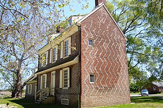
Seven Stars Tavern is a historic building located at the junction of Sharptown-Swedesboro Road and Woodstown-Auburn Road in Pilesgrove Township of Salem County, New Jersey and near Woodstown. The building was built in 1762 and was added to the National Register of Historic Places on May 17, 1976, for its significance in architecture, military, and social history. It is now a private residence.
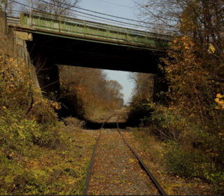
The Salem Branch is a rail freight line in the southwestern part of New Jersey in the United States between the Port of Salem and Woodbury Junction where it and the Penns Grove Secondary converge with the Vineland Secondary approximately 8.5 miles (13.7 km) south of Pavonia Yard in Camden.
Marshalltown is an unincorporated community located within Mannington Township, in Salem County, New Jersey. It has also been known as Frogtown.


