
The Ashburnham Center Historic District is a historic district encompassing the core of the village center of Ashburnham, Massachusetts in the United States. It is a well-preserved industrial village that experienced its most significant period of growth in the mid-19th century. The district was added to the National Register of Historic Places in 1999.

The Old Douglas Center Historic District encompasses the historic heart of Douglas, Massachusetts. The historic district radiates away from the town common, and is bounded by farmlands and more recent 20th-century development. There are 50 contributing resources in the 192-acre (78 ha) district. Most of the structures are residential houses in Federal and Greek Revival styles. There are a number of institutional buildings, including the 1834 Greek Revival First Congregational Church, the Craftsman-style Douglas Pastime Club building at 22 Church Street, and the c. 1770s Dudley Tavern. The town common and the adjacent Center Cemetery, laid out when the town was incorporated in 1746, are at the center of the district.

The Elm–Maple–South Streets Historic District is a historic district encompassing part of the historic downtown of Stockbridge, Massachusetts. The most prominent parts of Stockbridge lie within the Main Street Historic District, which abuts this district to the north. The southern boundary of this district is the railroad tracks that run parallel to the Housatonic River. The eastern boundary of the district is Laurel Hill, a wooded park overlooking the town, and the western boundary is a terraced shelf in the plains of the river. The district includes properties on Depot, Elm, Maple, and South Streets, and Laurel Lane. Unlike Main Street, this district consists of more densely place residences, and narrower roads containing businesses just off Main Street. Its buildings were mostly constructed during the late 19th and early 20th centuries, and partially reflect Elm Street's function as an industrial part of the town. The district was added to the National Register of Historic Places in 2004.
The Elm Street Historic District is a rural historic district in southern Hatfield, Massachusetts. It encompasses a landscape that has seen agricultural use since 17th century colonial days, including fields now used for tobacco farming, and historic properties located along five roads: Elm Street, Scotland Road, Sunset Road, Brook Hollow Road, and Little Neponset Road. The district is bounded on its south by the Connecticut River, on its east and north by the Mill River, with a small portion of land border in the northeast which cuts off a large meander in the river. This section, near the junction of Elm and Prospect Streets, is also where this district abuts the Mill-Prospect Street Historic District, which runs north along Prospect Street, and its eastern boundary abuts the Hatfield Center Historic District. Its western boundary is roughly a north-south line in the area of the junction of Elm and Dwight Streets.

The Lincoln–Sunset Historic District is a residential historic district located west of the downtown area of Amherst, Massachusetts. Colloquially known as Millionaire's Row, the district extends along Lincoln and Sunset Avenues between Northampton Street and the campus of the University of Massachusetts, Amherst. This area was one of Amherst's first planned residential subdivisions, and features a large number of high-quality houses, built by merchants, businessmen, and academics. It was added to the National Register of Historic Places in 1993.
The North Chester Historic District is a historic district encompassing the rural village center of North Chester in the town of Chester, Massachusetts. One of the rural community's early settlement nodes, it thrived into the early 19th century around a stagecoach tavern, a few small mills, and farming, and retains buildings and archaeological remains representative of this history. The district was listed on the National Register of Historic Places in 1998.
The South Amherst Common Historic District encompasses the village common and surrounding buildings of South Amherst, Massachusetts. This area developed as a rural residential village hub in the 18th and 19th centuries. It was listed on the National Register of Historic Places in 1995.

The Northampton Downtown Historic District encompasses most of the central business district of Northampton, Massachusetts. This area, which has been a center of commerce and industry in the area since colonial days, extends from the railroad tracks on the east side of the downtown, and west along Main Street to its junction with West Street and Elm Street. When the district was first listed on the National Register of Historic Places, it ended at the railroad tracks, and included properties on a number of other downtown streets; this was extended in 1985 to include a few properties just east of the railroad tracks on and near Bridge Street. The district includes such notable buildings as the 1891 Academy of Music Theatre, and Northampton's castle-like City Hall.

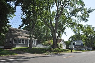
The Agawam Center Historic District is a historic district that encompasses part of the historic center of Agawam, Massachusetts. The district covers most of the buildings along Elm Street and Main Street radiating out from their intersection in both directions. The district is predominantly residential, although it does contain many commercial, industrial, and civic buildings. Many of the buildings in the district stand at a uniform setback from the street, giving the district a coherent feel.

The East End Historic District encompasses the historic eastern portion of central Ipswich, Massachusetts. The now predominantly residential district is bounded on the north and west by East Street, running from its junction with North Main and High Streets to Jeffrey's Neck Road. The eastern boundary includes the Ipswich River and Turkey Shore Road from its junction with Labor-in-Vain Road to Green Street, and the southern boundary runs along Green Street to North Main. The district was listed on the National Register of Historic Places in 1980.

The Hillside Historic District in Waterbury, Connecticut is a 106-acre (43 ha) historic district that was listed on the National Register of Historic Places (NRHP) in 1987. It encompasses a residential area north of the city's central business district, and is bounded on the south by West Main Street, the west by Willow Avenue and Cliff and Frederick Streets, on the north by Buckingham Street and Woodland Terrace, and on the east by Cooke Street. Developed principally over an 80-year period between 1840 and 1920, it includes a cross-section of architectural styles of the 19th and early 20th centuries. The area was a desirable neighborhood of the city for much of this time, and was home to a number of the city's elite. In 1987, it included 395 buildings deemed to contribute to the historic character of the area, and one other contributing structure. It includes the Wilby High School and the Benedict-Miller House, which are both separately listed. 32 Hillside Road, a several acre property that includes the Benedict Miller House, was the original site of The University of Connecticut's Waterbury Branch until 2003.

The East Leverett Historic District of Leverett, Massachusetts, encompasses the historic mill village of East Leverett. Centered on the intersection of Cushman Road and Shutesbury Road in the southeastern portion of the rural town, it includes predominantly residential buildings that were built during the height of the area's industrial activity in the first four decades of the 19th century. The architecture is mainly Federal and Greek Revival in style. The district was listed on the National Register of Historic Places in 2014.

The Head of the River Historic District is a historic district encompassing a village area at the head of navigation of the Acushnet River, which separates Acushnet and New Bedford, Massachusetts. The village is centered at the junction of Tarkiln Hill Road, River Road, and Mill Road in New Bedford, and Main Street in Acushnet. The area went through two significant periods of development: the first was in the late 18th and early 19th century, and the second was in the early 20th century. The district was listed on the National Register of Historic Places in 2009.

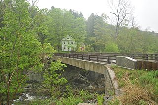
The Bellows Falls Neighborhood Historic District encompasses a residential area of the village of Bellows Falls, Vermont. Located south of downtown Bellows Falls, the area has one of the largest concentrations of well-preserved 19th century residences in southern Vermont. It was listed on the National Register of Historic Places in 2002, and enlarged in 2007.

The Wallingford Main Street Historic District encompasses the historic portions of the village of Wallingford, Vermont. An essentially linear district extending along Main Street on either side of School Street, it has a well-preserved array of 19th and early-20th century residential, commercial, and civic buildings. It was listed on the National Register of Historic Places in 1984.

The Terraces Historic District encompasses a historic late 19th and early 20th-century residential area of White River Junction, Vermont. The district, developed as an upper middle-class residential area beginning in 1880, features a variety of architectural styles encapsulating the community's growth through about 1930. It was listed on the National Register of Historic Places in 2012.

The Maple Street–Clarks Avenue Historic District encompasses a historic 19th-century immigrant neighborhood of St. Johnsbury, Vermont. Located northwest of the downtown area on a sloping hillside, it consists of tenements and single-family houses built for Irish and French Canadian immigrants, sometimes grouped in ways that facilitated the support of large extended families. The district was listed on the National Register of Historic Places in 1994.

The St. Johnsbury Historic District encompasses much of the historic civic and commercial center of St. Johnsbury, Vermont. Representing a significant expansion of the Railroad Street Historic District and the St. Johnsbury Main Street Historic District, it captures the historical tension and competition between Main Street and Railroad Street for primacy as the town's most important civic and commercial areas. The district was listed on the National Register of Historic Places in 1980.

The Rockwood Road Historic District encompasses a portion of the town center of Norfolk, Massachusetts that has retained significant 19th-century characteristics. It extends along Rockwood Road from the MBTA Commuter Rail line to Boardman Street. This area consists mainly of residential or former residential buildings, as well as the 1863 Norfolk Grange Hall, a former church, and is reflective of the center's growth as a railroad village. The district was added to the National Register of Historic Places in 2017.

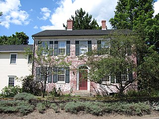
The Central Avenue-Center Cemetery Historic District encompasses part of the town center of East Hartford, Connecticut. Although it was founded in the mid-17th century, it is now dominated by architecture of the late 19th and early 20th centuries. The Center Cemetery is the town's oldest surviving property, and includes the grave of William Pitkin, a colonial governor. The district, including portions of Main Street and Central Avenue, was listed on the National Register of Historic Places in 1993.


