Pont-Hébert

Last updated • 1 min readFrom Wikipedia, The Free Encyclopedia

Pont-Hébert
Pont-Hebert - Vue sur le bourg.jpg
Pont-Hébert viewed from the bridge over the Vire
Location of Pont-Hébert
Pont-Hebert
France location map-Regions and departements-2016.svg
Red pog.svg
Pont-Hébert
Normandie region location map.svg
Red pog.svg
Pont-Hébert
Coordinates: 49°10′04″N1°07′55″W / 49.1678°N 1.1319°W / 49.1678; -1.1319
Country France
Region Normandy
Department Manche
Arrondissement Saint-Lô
Canton Pont-Hébert
Intercommunality Saint-Lô Agglo
Government
  Mayor (20202026) Michel Richomme [1]
Area
1
29.84 km2 (11.52 sq mi)
Population
 (2021) [2]
1,907
  Density64/km2 (170/sq mi)
Time zone UTC+01:00 (CET)
  Summer (DST) UTC+02:00 (CEST)
INSEE/Postal code
50409 /50880
Elevation5–83 m (16–272 ft)
(avg. 49 m or 161 ft)
1 French Land Register data, which excludes lakes, ponds, glaciers > 1 km2 (0.386 sq mi or 247 acres) and river estuaries.

Pont-Hébert (French pronunciation: [pɔ̃ebɛʁ] ) is a commune in the Manche department in Normandy in north-western France. On 1 January 2018, the former commune of Le Hommet-d'Arthenay was merged into Pont-Hébert. [3]

Contents

Geography

Climate

Pont-Hébert has an oceanic climate (Köppen climate classification Cfb). The average annual temperature in Pont-Hébert is 11.6 °C (52.9 °F). The average annual rainfall is 972.3 mm (38.28 in) with December as the wettest month. The temperatures are highest on average in August, at around 17.9 °C (64.2 °F), and lowest in January, at around 5.7 °C (42.3 °F). The highest temperature ever recorded in Pont-Hébert was 37.8 °C (100.0 °F) on 5 August 2003; the coldest temperature ever recorded was −13.5 °C (7.7 °F) on 2 January 1997.

Climate data for Pont-Hébert (1981–2010 averages, extremes 1996−2010)
MonthJanFebMarAprMayJunJulAugSepOctNovDecYear
Record high °C (°F)15.3
(59.5)
19.0
(66.2)
22.3
(72.1)
24.5
(76.1)
30.3
(86.5)
33.5
(92.3)
32.8
(91.0)
37.8
(100.0)
32.1
(89.8)
24.8
(76.6)
19.0
(66.2)
16.2
(61.2)
37.8
(100.0)
Mean daily maximum °C (°F)8.3
(46.9)
9.5
(49.1)
11.7
(53.1)
14.0
(57.2)
17.4
(63.3)
20.4
(68.7)
21.9
(71.4)
22.5
(72.5)
20.2
(68.4)
16.2
(61.2)
11.9
(53.4)
8.8
(47.8)
15.3
(59.5)
Daily mean °C (°F)5.7
(42.3)
6.5
(43.7)
8.1
(46.6)
10.0
(50.0)
13.3
(55.9)
16.0
(60.8)
17.5
(63.5)
17.9
(64.2)
15.9
(60.6)
12.8
(55.0)
9.0
(48.2)
6.0
(42.8)
11.6
(52.9)
Mean daily minimum °C (°F)3.1
(37.6)
3.5
(38.3)
4.5
(40.1)
6.0
(42.8)
9.2
(48.6)
11.5
(52.7)
13.1
(55.6)
13.3
(55.9)
11.5
(52.7)
9.4
(48.9)
6.2
(43.2)
3.3
(37.9)
7.9
(46.2)
Record low °C (°F)−13.5
(7.7)
−8.0
(17.6)
−5.0
(23.0)
−1.7
(28.9)
1.3
(34.3)
4.2
(39.6)
7.5
(45.5)
6.7
(44.1)
4.4
(39.9)
−3.9
(25.0)
−4.2
(24.4)
−7.5
(18.5)
−13.5
(7.7)
Average precipitation mm (inches)92.9
(3.66)
74.3
(2.93)
74.7
(2.94)
68.8
(2.71)
79.9
(3.15)
54.0
(2.13)
63.7
(2.51)
73.6
(2.90)
71.6
(2.82)
102.9
(4.05)
105.9
(4.17)
110.0
(4.33)
972.3
(38.28)
Average precipitation days (≥ 1.0 mm)14.412.312.912.110.39.411.49.49.614.516.015.8147.9
Source: Meteociel [4]

See also

Related Research Articles

<span class="mw-page-title-main">Coutances</span> Subprefecture and commune in Normandy, France

Coutances is a commune in the Manche department in Normandy in north-western France.

<span class="mw-page-title-main">Joinville-le-Pont</span> Commune in Île-de-France, France

Joinville-le-Pont is a commune in the southeastern suburbs of Paris, France. It is located 9.4 km (5.8 mi) from the center of Paris.

<span class="mw-page-title-main">Saint-Hilaire-du-Harcouët</span> Commune in Normandy, France

Saint-Hilaire-du-Harcouët is a commune in the Manche department in Normandy in north-western France. On 1 January 2016, the former communes of Saint-Martin-de-Landelles and Virey were merged into Saint-Hilaire-du-Harcouët.

<span class="mw-page-title-main">Brouzet-lès-Alès</span> Commune in Occitanie, France

Brouzet-lès-Alès is a commune in the Gard department in southern France.

<span class="mw-page-title-main">Mandagout</span> Commune in Occitania, France

Mandagout is a commune in the Gard department in southern France. The 18th-century French pharmacist, chemist and encyclopediste Jacques Montet (17221782) was born in Mandagout.

<span class="mw-page-title-main">Les Aires</span> Commune in Occitania, France

Les Aires is a commune in the Hérault department in the Occitanie region in southern France.

<span class="mw-page-title-main">Prades-le-Lez</span> Commune in Occitania, France

Prades-le-Lez is a commune in the Hérault department in the Occitanie region in southern France.

<span class="mw-page-title-main">Palaminy</span> Commune in Occitania, France

Palaminy is a commune in the Haute-Garonne department in southwestern France.

<span class="mw-page-title-main">Villematier</span> Commune in Occitania, France

Villematier is a commune in the Haute-Garonne department in southwestern France.

<span class="mw-page-title-main">Moulès-et-Baucels</span> Commune in Occitania, France

Moulès-et-Baucels is a commune in the Hérault department in the Occitanie region in southern France.

<span class="mw-page-title-main">Murviel-lès-Béziers</span> Commune in Occitania, France

Murviel-lès-Béziers is a commune in the Hérault department in the Occitanie region in southern France.

<span class="mw-page-title-main">Brécey</span> Commune in Normandy, France

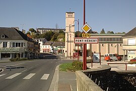
Brécey is a commune in the Manche department in Normandy in northwestern France. It is located on the crossing of the D999 and D911 roads.

<span class="mw-page-title-main">Condé-sur-Vire</span> Commune in Normandy, France

Condé-sur-Vire is a commune in the Manche department in Normandy in north-western France. On 1 January 2016, the former commune of Le Mesnil-Raoult was merged into Condé-sur-Vire. On 1 January 2017, the former commune of Troisgots was merged into Condé-sur-Vire.

<span class="mw-page-title-main">Coulouvray-Boisbenâtre</span> Commune in Normandy, France

Coulouvray-Boisbenâtre is a commune in the Manche department in Normandy in north-western France.

<span class="mw-page-title-main">Le Poizat-Lalleyriat</span> Commune in Auvergne-Rhône-Alpes, France

Le Poizat-Lalleyriat is a commune in the Ain department of eastern France. The municipality was established on 1 January 2016 and consists of the former communes of Lalleyriat and Le Poizat.

<span class="mw-page-title-main">Les Belleville</span> Commune in Auvergne-Rhône-Alpes, France

Les Belleville is a commune in the Savoie department of southeastern France. The municipality was established on 1 January 2016 by the merger of the former communes of Saint-Martin-de-Belleville and Villarlurin. On 1 January 2019, the former commune Saint-Jean-de-Belleville was merged into Les Belleville.

<span class="mw-page-title-main">Bricquebec-en-Cotentin</span> Commune in Normandy, France

Bricquebec-en-Cotentin is a commune in the department of Manche, northwestern France. The municipality was established on 1 January 2016 by merger of the former communes of Bricquebec, Les Perques, Quettetot, Saint-Martin-le-Hébert, Le Valdécie and Le Vrétot.

<span class="mw-page-title-main">Gonneville-le-Theil</span> Commune in Normandy, France

Gonneville-le-Theil is a commune in the department of Manche, northwestern France. The municipality was established on 1 January 2016 by merger of the former communes of Gonneville and Le Theil.

Les Achards is a commune in the department of Vendée, western France. The municipality was established on 1 January 2017 by merger of the former communes of La Mothe-Achard and La Chapelle-Achard.

<span class="mw-page-title-main">Arvière-en-Valromey</span> Commune in Auvergne-Rhône-Alpes, France

Arvière-en-Valromey is a commune in the Ain department in eastern France. The municipality was established on 1 January 2019 by merger of the former communes of Brénaz, Chavornay, Lochieu and Virieu-le-Petit.

References

  1. "Répertoire national des élus: les maires" (in French). data.gouv.fr, Plateforme ouverte des données publiques françaises. 13 September 2022.
  2. "Populations légales 2021" (in French). The National Institute of Statistics and Economic Studies. 28 December 2023.
  3. Arrêté préfectoral 13 December 2017 (in French)
  4. "Normales et records pour Pont-Hebert (50)". Meteociel. Retrieved 7 June 2022.