Big Kangaroo is an 8,326-foot (2,538-metre) mountain summit in Okanogan County, Washington, United States.

Cutthroat Peak is an 8,066-foot-elevation (2,459-meter) granitic mountain located on the boundary of Chelan County and Skagit County, in Washington state. The mountain is part of the Okanagan Range which is a subrange of the Cascade Range, and it is situated within the Okanogan–Wenatchee National Forest. Cutthroat Peak is set about two miles west of Washington Pass and one mile east of Rainy Pass. It is a prominent landmark along the North Cascades Highway with an accessible climbing route. Topographic relief is significant as the summit rises over 3,000 feet above State Creek in one mile (1.6 km). There is also a Cutthroat Lake, Cutthroat Creek, and Cutthroat Pass on its north and east aspects. This landform's toponym was officially adopted in 1988 by the United States Board on Geographic Names. Molar Tooth is a granite pillar half a mile north on the ridge extending to Cutthroat Pass.

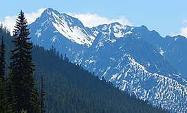
Mount Hardy is an 8,099-foot (2,469-metre) mountain summit located on the common border of Okanogan County with Skagit County in Washington state. It is part of the Okanogan Range which is a sub-range of the North Cascades Range. Mount Hardy is situated west of Methow Pass, at headwaters of the Methow River, on land administered by the Okanogan–Wenatchee National Forest. Topographic relief is significant as the summit rises approximately 2,500 feet above the West Fork Methow River in one-half mile (0.8 km). The nearest higher peak is Golden Horn, 1.75 miles (2.82 km) to the northeast. Mount Hardy can be seen from the North Cascades Highway which traverses below the southwestern base of the mountain. This mountain's toponym was officially adopted in 1973 by the United States Board on Geographic Names.

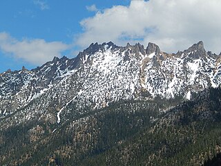
The Needles is an 8,160-foot (2,487-metre) granite mountain located in Okanogan County in Washington state. It is part of the Okanogan Range which is a sub-range of the North Cascades Range. The Needles is situated on land administered by the Okanogan–Wenatchee National Forest. Precipitation runoff from the peak drains into tributaries of the Methow River. Topographic relief is significant as the summit rises 3,660 feet above Pine Creek in approximately 1.25 mile (2 km). The nearest higher neighbor is Tower Mountain, 2.26 miles (3.64 km) to the southwest.

Hinkhouse Peak is a 7,566-foot-elevation (2,306-meter) mountain summit located on the shared border of Okanogan County and Chelan County in Washington state. It is part of the Okanogan Range which is a sub-range of the North Cascades Range. Hinkhouse Peak is situated on land administered by the Okanogan–Wenatchee National Forest. The nearest higher neighbor is Liberty Bell Mountain, 1.52 miles (2.45 km) to the south. Hinkhouse Peak is situated north of Washington Pass, at the east end of a high ridge which connects to Cutthroat Peak. A high ridge extending northeast connects it to Constitution Crags. Most precipitation runoff from the peak drains into Early Winters Creek which is a tributary of the Methow River, but the south slope drains into a tributary of the Chelan River. Topographic relief is significant as it rises nearly 3,200 feet above Early Winters Creek in approximately one mile (1.6 km).

Azurite Peak is an 8,434-foot (2,571-metre) double-summit mountain located at the common boundary point of Okanogan County, Skagit County, and Whatcom County in Washington state. It is part of the Okanogan Range which is a sub-range of the North Cascades Range. Azurite Peak ranks as the 81st-highest summit in the state. Azurite Peak is situated north of Azurite Pass on land administered by the Okanogan–Wenatchee National Forest. The nearest higher neighbor is Tower Mountain, 5.24 miles (8.43 km) to the south-southeast, and Mount Ballard lies 1.97 miles (3.17 km) to the north. Remnants of a small pocket glacier are found on the east aspect. Precipitation runoff from the peak drains north into tributaries of the Skagit River, and south into the Methow River. Topographic relief is significant as the summit rises over 3,000 feet above Mill Creek in one mile (1.6 km). The Pacific Crest Trail traverses the base of Azurite Peak.
Vasiliki Ridge is a three-mile-long ridge located in Okanogan County of Washington state. It is part of the Methow Mountains which are a sub-range of the North Cascades. Vasiliki Ridge is situated north of Silver Star Mountain on land administered by the Okanogan–Wenatchee National Forest. Vasiliki Ridge can be seen from Washington Pass and from the North Cascades Highway.

Blue Lake Peak is a 7,808-foot (2,380-metre) mountain summit in the North Cascades of Washington state. It is located in the Okanogan–Wenatchee National Forest on the shared border of Okanogan County and Chelan County. The peak is situated south of Early Winters Spires, Liberty Bell Mountain, and Washington Pass. Blue Lake is set below its west slope, and Stiletto Peak is to its south. Blue Lake Peak can be seen from the North Cascades Highway at the Blue Lake Trailhead. Precipitation runoff from Blue Lake Peak drains into tributaries of the Chelan River and Methow River. Topographic relief is significant as the summit rises 2,800 feet above Early Winters Creek in one mile (1.6 km). The mountain's toponym has not been officially adopted by the United States Board on Geographic Names. An alternate name, "Wamihaspi Peak," was published by mountaineer and author, Fred Beckey, in his guidebook.

Blackbeard Peak, also spelled Black Beard Peak, is a 7,241-foot mountain summit in the North Cascades in the U.S. state of Washington. It is located in the Okanogan–Wenatchee National Forest in Skagit County. It is situated northwest of Rainy Pass, southwest of Porcupine Peak, and southeast of Graybeard Peak. Its nearest higher neighbor is Repulse Peak, 1.06 mi (1.71 km) to the west. Blackbeard Peak can be seen from the North Cascades Highway. Precipitation runoff from Blackbeard Peak drains into Granite Creek, a tributary of the Skagit River. Topographic relief is significant as the summit rises over 3,000 feet above Granite Creek in one mile (1.6 km).

Crooked Bum is a 6,937-foot-elevation mountain summit on the crest of the North Cascades in the U.S. state of Washington. It is located in the Okanogan–Wenatchee National Forest on the shared border of Skagit County and Chelan County. It is situated immediately west of Rainy Pass and two miles east of Corteo Peak. The scenic and popular Maple Pass Trail traverses the south slope of the peak while staying above Lake Ann. Precipitation runoff from the north slope of Crooked Bum drains into Granite Creek which is a tributary of the Skagit River, whereas the south side drains into Bridge Creek which is a tributary of the Chelan River.

Holliway Mountain is an 8000+ ft granite summit located in Okanogan County in Washington state. It is part of the Okanogan Range which is a sub-range of the North Cascades Range. Holliway Mountain is situated near the headwaters of the Methow River on land administered by the Okanogan–Wenatchee National Forest. The nearest higher peak is Golden Horn, 0.91 miles (1.46 km) to the south. Azurite Peak is located three miles to the north-northwest.
Molar Tooth is a 7,547-foot-elevation (2,300-meter) granite summit located on the shared border of Okanogan County and Skagit County, in Washington state. The mountain is part of the Okanagan Range which is a subrange of the Cascade Range. Set in the Okanogan–Wenatchee National Forest, Molar Tooth is situated south of Cutthroat Pass, and 0.57 miles (0.92 km) north of Cutthroat Peak, which is also the nearest higher peak. The easiest climbing route is class 4 scrambling, but solid rock provides class 5 technical routes as well. Precipitation runoff from the east side of Molar Tooth drains into tributaries of the Methow River, whereas runoff from the west side drains into tributaries of the Skagit River.

Constitution Crags is a 6,978-foot-elevation summit located in Okanogan County of Washington state. It is part of the Okanogan Range which is a sub-range of the North Cascades. Constitution Crags is situated west of Silver Star Mountain on land administered by the Okanogan–Wenatchee National Forest. The nearest higher neighbor is Hinkhouse Peak, 0.62 mile to the southwest. Washington Pass is located over a mile south of Constitution Crags, and the North Cascades Highway traverses below the east face of Constitution Crags. Like many North Cascade peaks, Constitution Crags is more notable for its large, steep rise above local terrain than for its absolute elevation. Topographic relief is significant as the summit rises nearly 2,700 feet above Early Winters Creek in approximately one mile (1.6 km). Precipitation runoff from the peak drains into Early Winters Creek which is a tributary of the Methow River.

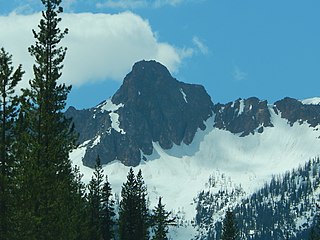
Castle Peak is a prominent 8,343-foot (2,543-metre) mountain summit located in the Hozameen Range of the North Cascades, on the shared border between Okanogan County and Whatcom County of Washington state. The mountain is situated one mile (1.6 km) south of the Canada–United States border, on the Cascade crest, in the Pasayten Wilderness, on land managed by the Okanogan–Wenatchee National Forest. The nearest higher peak is Jack Mountain, 14.8 miles (23.8 km) to the south-southwest. Castle Peak is the second highest summit of the Hozameen Range following Jack Mountain. Castle Peak is the sixth-highest mountain in the Pasayten Wilderness. Precipitation runoff from the mountain drains east into Castle Creek, a tributary of the Similkameen River, or west into tributaries of the Skagit River. Topographic relief is significant as the summit rises nearly 3,000 feet above Crow Creek in 0.75 mile (1.2 km).

Granite Mountain is a 7,144-foot (2,177-metre) double summit mountain located 11.5 mi (18.5 km) south of Stevens Pass on the common border of Kittitas County and Chelan County in Washington state. It's part of the Wenatchee Mountains, which are a subset of the Cascade Range, and is situated 19 mi (31 km) west of Leavenworth in the Alpine Lakes Wilderness, on land managed by the Okanogan–Wenatchee National Forest. Granite Mountain is the highest point on the Hyas Lake-French Creek divide with precipitation runoff from the mountain draining west into Cle Elum River, or east into French Creek, a tributary of Icicle Creek. Its subsidiary 7,080-ft South Peak is positioned half a mile to the south-southeast, the nearest higher neighbor is The Cradle, 3 mi (4.8 km) to the southeast, and Mac Peak is set 3.6 mi (5.8 km) to the north-northwest. The Pacific Crest Trail skirts below the western base this peak.

Skagit Peak is a 6,824-foot (2,080-metre) mountain summit located in the North Cascades, in Whatcom County of Washington state. It is situated on the western side of the Cascade crest, at the western edge of the Pasayten Wilderness, on land managed by the Okanogan–Wenatchee National Forest. Skagit Peak is part of the Hozameen Range, a subset of the North Cascades which also includes Hozomeen Mountain to the north, and Jack Mountain to the south. Precipitation runoff from this mountain drains into the Skagit River via Three Fools Creek and Ross Lake.

Spratt Mountain is a 7,258-foot (2,212-metre) mountain summit located in the North Cascades, in Whatcom County of Washington state. It is situated on the western side of the Cascade crest, at the western edge of the Pasayten Wilderness, on land managed by the Okanogan–Wenatchee National Forest. Spratt Mountain is part of the Hozameen Range, a subset of the North Cascades which also includes Skagit Peak four miles to the north, and Jack Mountain six miles to the south. Precipitation runoff from this mountain drains into Ross Lake via Three Fools Creek and Dry Creek.

Syncline Mountain is a 7,560-foot (2,300-metre) mountain summit located on the shared border between Okanogan County and Whatcom County in Washington state. It is part of the Okanogan Range, which is a sub-range of the North Cascades, and is situated on land managed by the Okanogan–Wenatchee National Forest. Its nearest neighbor is Tatie Peak, 0.8 miles (1.3 km) to the north, and the nearest higher neighbor is Mount Ballard, 2.1 miles (3.4 km) to the west. The Pacific Crest Trail traverses the east slope of the peak, with an off-trail scramble to reach the summit. Precipitation runoff from Syncline Mountain drains east into Trout Creek which is a tributary of the Methow River, or northwest into Slate Creek, which is part of the Skagit River drainage basin. This unofficially named mountain features a conspicuous syncline, hence its descriptive name.

Le Conte Mountain is a 7,762-foot-elevation (2,366-meter) summit located on the shared boundary of Skagit County and Chelan County in Washington state. It is positioned on the crest of the North Cascades Range, and is set within the Glacier Peak Wilderness. Le Conte Mountain is situated on the shared border of Mount Baker-Snoqualmie National Forest and Okanogan-Wenatchee National Forest. Access to the peak is via the Ptarmigan Traverse. The nearest higher neighbor is Sentinel Peak, 1.87 miles (3.01 km) to the south-southeast, and Spider Mountain is 2.4 miles (3.9 km) to the northeast. The Le Conte Glacier and South Cascade Glacier lie to the south of the peak. Precipitation runoff on the east side the mountain drains into Flat Creek which is a tributary of the Stehekin River, while precipitation drains into headwaters of the South Fork Cascade River from the west side. Topographic relief is significant as the southwest aspect rises nearly 2,500 feet above South Cascade Lake in less than one-half mile, and the northeast aspect rises 3,200 feet above Flat Creek in one mile.
Majestic Mountain is a 7,530-foot-elevation (2,295-meter) mountain summit located in Whatcom County in Washington state.