
Big Kangaroo is an 8,326-foot (2,538-metre) mountain summit in Okanogan County, Washington, United States.

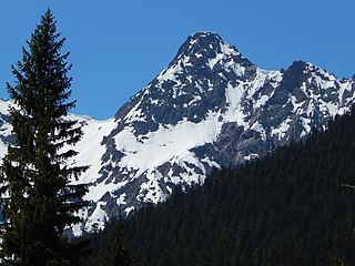
Graybeard Peak is a 7,965-foot (2,428-metre) mountain summit located in Skagit County, Washington.

The Needles is an 8,160-foot (2,487-metre) granite mountain located in Okanogan County in Washington state. It is part of the Okanogan Range which is a sub-range of the North Cascades Range. The Needles is situated on land administered by the Okanogan–Wenatchee National Forest. Precipitation runoff from the peak drains into tributaries of the Methow River. Topographic relief is significant as the summit rises 3,660 feet above Pine Creek in approximately 1.25 mile (2 km). The nearest higher neighbor is Tower Mountain, 2.26 miles (3.64 km) to the southwest.

Ruby Mountain is a prominent 7,412-foot (2,259-metre) mountain summit located in the North Cascades Range of Washington state. It is situated in Ross Lake National Recreation Area which is part of the North Cascades National Park Complex. The Diablo Lake Overlook along the North Cascades Highway is at the foot of the mountain. The nearest higher peak is Colonial Peak, 4.2 miles (6.8 km) to the southwest. Precipitation runoff on the east side of the mountain drains to Ross Lake via Ruby Creek, whereas the west side of the mountain drains to Diablo Lake via Thunder Creek. Topographic relief is significant as the summit rises 6,200 feet above Diablo Lake in approximately two miles.

Frisco Mountain is a 7,760-foot (2,365-metre) mountain summit in the Cascade Range in the U.S. state of Washington. It is located two miles southwest of Rainy Pass on the borders of the Stephen Mather Wilderness and North Cascades National Park. First climbed by surveyor Lage Wernstedt in 1926, the mountain derives its name from a mining claim on the south side that was worked in the 1920s. Its nearest higher peak is Rainy Peak, 0.54 mi (0.87 km) to the east-southeast. Precipitation runoff from Frisco Mountain drains into Rainy Lake and tributaries of Bridge Creek. The retreating Lyall Glacier in its northeast cirque contributes to waterfalls which tumble 1,000 ft (300 m) into Rainy Lake.
Kitling Peak is an 8,003-foot (2,439-metre) mountain summit in the North Cascades in the U.S. state of Washington. It is located one mile northwest of Easy Pass on the borders of the Stephen Mather Wilderness and North Cascades National Park. Kitling Peak is situated at the east end of Ragged Ridge. Other peaks on Ragged Ridge include Mesahchie Peak, Kimtah Peak, Katsuk Peak, and Graybeard Peak. The nearest higher peak is Mesahchie Peak, 0.95 miles (1.53 km) to the south. The Mesahchie Glacier on Kitling's northwest slope forms the headwaters of Panther Creek. Precipitation runoff on the east side of the mountain drains into Ross Lake via Granite Creek, whereas the west side of the peak drains into Diablo Lake via Panther Creek and Fisher Creek. Topographic relief is significant as the summit rises 3,000 feet above Fisher Creek in one mile (1.6 km) and the northeast slope rises 3,400 feet above Kitling Creek in 0.75 mile (1.2 km). The mountain's name "Kitling" derives from Chinook Jargon "ketling" which means kettle. The mountain takes its name from Kitling Lake which is one mile north of the peak. The toponym was officially adopted in 1969 by the U.S. Board on Geographic Names.
Beebe Mountain is a 7,416-foot (2,260-metre) mountain summit located in the Cascade Range in the U.S. state of Washington. It is situated on the border of North Cascades National Park. Its nearest higher neighbor is Elija Ridge, 1.86 miles (2.99 km) to the southwest, and McKay Ridge is set 4 miles (6.4 km) to the northeast on the opposite side of the North Cascades Highway. The mountain's name honors Frank Beebe who worked for the Forest Service and maintained a cabin near the base of the mountain in the 1920s. Precipitation runoff on the mountain drains into Ross Lake via Granite Creek and Panther Creek.

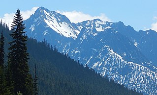
Repulse Peak is a 7,923-foot (2,415-metre) mountain summit in the North Cascades in the U.S. state of Washington. It is located on the border of the Stephen Mather Wilderness and North Cascades National Park. It is situated midway between Black Peak and Fisher Peak, and can be seen from the North Cascades Highway. Precipitation runoff from Repulse Peak drains into tributaries of the Skagit River and Stehekin River. Topographic relief is significant as the east face rises over 2,900 feet in 0.53 mile (0.85 km).
Porcupine Peak is a 7,762-foot-elevation (2,366-meter) mountain located in Skagit County of Washington state.

Stiletto Peak is a 7,660 ft summit located in the Methow Mountains, a sub-range of the North Cascades in Washington state. It is situated in the Stephen Mather Wilderness on a ridge which also has Switchblade Peak and Jackknife Peak to its east. Stiletto Peak is also located on the boundary of North Cascades National Park, 2.24 miles (3.60 km) due north of Hock Mountain. Precipitation runoff on the north side of the mountain drains to Bridge Creek via Copper Creek, whereas the south side of the mountain drains into the East Fork Bridge Creek.

Red Mountain is a 7,662-foot (2,335-metre) summit in the North Cascades of Washington, United States. It is located in Skagit County, within North Cascades National Park and the Stephen Mather Wilderness. It is situated on a smooth ridge of brick-red color at the western culmination of Ragged Ridge. The nearest higher peak is Cosho Peak, 2.6 miles (4.2 km) to the east-southeast.

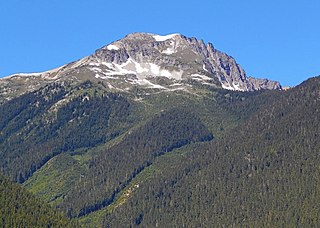
Mount Misch is a remote 7,435 ft mountain summit in the North Cascades, in Skagit County of Washington state. It is the highest point of the Buckindy Range, or Buckindy Ridge. It is located 19 miles east-northeast of Darrington, Washington, and 15 miles north-northwest of Glacier Peak which is one of the Cascade stratovolcanoes. It is situated in the Glacier Peak Wilderness on land administered by the Mount Baker-Snoqualmie National Forest. Mount Misch was named by mountaineer and author Fred Beckey for his friend Peter Misch (1909-1987), University of Washington geology professor and mountaineer, who was renowned for his study of the North Cascades. Precipitation runoff from Mount Misch and the unnamed Goat Creek glacier on its east slope drains into tributaries of the Suiattle River and ultimately the Skagit River.

Copper Benchmark, also known as Copper Point, is a 7,844-foot-elevation (2,391-meter) mountain summit located on the shared border between Okanogan County and Chelan County in Washington state. Copper Benchmark is part of the Methow Mountains which are a subrange of the North Cascades, and it is situated on the crest of the Cascade Range between Kangaroo Pass and Copper Pass. It was used as a triangulation station for early surveying. It is protected by the Lake Chelan-Sawtooth Wilderness within the Okanogan–Wenatchee National Forest. Copper Benchmark has a subsidiary peak, Pica Peak (elevation 7,565 feet, which is 0.52 miles northwest of the summit. The nearest higher peak is Wallaby Peak, 0.9 miles to the northeast. Precipitation runoff on the north side of the mountain drains to the Methow River via Early Winters Creek, whereas the other sides of the mountain drain into tributaries of the Chelan River.

Mount Ballard is an 8,371-foot (2,551-metre) double-summit mountain located in eastern Whatcom County of Washington state. It is part of the Okanogan Range which is a sub-range of the North Cascades Range, and the mountain is situated on land administered by the Okanogan–Wenatchee National Forest. Ballard ranks 84th on Washington's highest 100 peaks. The nearest higher neighbor is Azurite Peak, 2.04 miles (3.28 km) to the south. Precipitation runoff from Mount Ballard drains into Mill Creek and Slate Creek, both tributaries of the Skagit River. Topographic relief is significant as the summit rises approximately 4,000 feet above Mill Creek in one mile (1.6 km).

Monument Peak is an 8,597-foot (2,620-metre) mountain summit located in western Okanogan County in Washington state. It is part of the Okanogan Range which is a sub-range of the North Cascades. The mountain is situated in the Pasayten Wilderness, on land administered by the Okanogan–Wenatchee National Forest. The nearest higher peak is Mount Lago, 2.42 miles (3.89 km) to the north. Precipitation runoff from Monument Peak drains east into Monument Creek, and west into Eureka Creek, which are both part of the Methow River drainage basin. Topographic relief is significant as the summit rises 3,800 feet above Eureka Creek in 1.25 mile (2 km).
Robinson Mountain is an 8,731-foot (2,661-metre) mountain summit located in western Okanogan County in Washington state. It is part of the Okanogan Range which is a sub-range of the North Cascades Range. The mountain is situated in the Pasayten Wilderness, on land administered by the Okanogan–Wenatchee National Forest. The nearest higher peak is Mount Lago, 7.28 miles (11.72 km) to the north. Precipitation runoff from Robinson Mountain drains west into Robinson Creek, and east into Eureka Creek, which are both part of the Methow River drainage basin. The mountain is named for brothers James and Thomas Robinson who were settlers in the area in the late 1800s.

Apex Mountain is an 8,302-foot (2,530-metre) summit located in Okanogan County in Washington state. It is part of the Okanogan Range which is a sub-range of the North Cascades. The mountain is situated 2.5 miles (4.0 km) south of the Canada–United States border, on the east side of the Cascade crest, in the Pasayten Wilderness, on land managed by the Okanogan–Wenatchee National Forest. The nearest higher peak is Amphitheater Mountain, 2.35 miles (3.78 km) to the west-northwest. The Pacific Northwest Trail traverses the northern slopes of Apex Mountain as it crosses Apex Pass. Precipitation runoff from Apex Mountain drains west into Cathedral Creek, or east into Tungsten Creek, both tributaries of the Chewuch River. Topographic relief is significant as the summit rises 1,200 feet above Tungsten Lake in 0.3 mile (0.5 km).

Wallaby Peak is a 7,995-foot (2,437-metre) mountain summit located on the boundary line of the Lake Chelan-Sawtooth Wilderness, in Okanogan County, Washington. The mountain is part of the Methow Mountains, which are a subset of the Cascade Range. Wallaby Peak is situated on Kangaroo Ridge which is approximately two miles east and within view of Washington Pass. The nearest higher peak is Big Kangaroo, 0.86 mi (1.38 km) to the north. Precipitation runoff from the peak drains into Early Winters Creek, Cedar Creek, and North Fork Twisp River, all of which are tributaries of the Methow River.

Half Moon is a 7,960+ ft summit located in Okanogan–Wenatchee National Forest, in Okanogan County, of Washington state. The mountain is part of the Methow Mountains, which are a subset of the Cascade Range. Half Moon is situated on Kangaroo Ridge which is approximately two miles east and within view of the North Cascades Highway at Washington Pass. The nearest higher neighbor is Wallaby Peak, 0.23 mi (0.37 km) to the south. Precipitation runoff from the peak drains into Early Winters Creek, and Cedar Creek, both of which are tributaries of the Methow River.

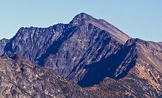
Syncline Mountain is a 7,560-foot (2,300-metre) mountain summit located on the shared border between Okanogan County and Whatcom County in Washington state. It is part of the Okanogan Range, which is a sub-range of the North Cascades, and is situated on land managed by the Okanogan–Wenatchee National Forest. Its nearest neighbor is Tatie Peak, 0.8 miles (1.3 km) to the north, and the nearest higher neighbor is Mount Ballard, 2.1 miles (3.4 km) to the west. The Pacific Crest Trail traverses the east slope of the peak, with an off-trail scramble to reach the summit. Precipitation runoff from Syncline Mountain drains east into Trout Creek which is a tributary of the Methow River, or northwest into Slate Creek, which is part of the Skagit River drainage basin. This unofficially named mountain features a conspicuous syncline, hence its descriptive name.


